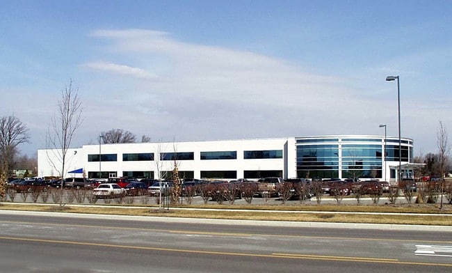
Property Record
6620 Network Way, Indianapolis, IN 46278

NEARBY LISTINGS FOR SALE OR LEASE
Property Detail
6620 Network Way
49-04-35-117-014.000-600
PT NW1/4 S35 T17 R2 BEG 1524.92 N OF SW COR P.O.B. N73.56 E603.76 S73.56 W604.24 TO BEG
Parkinglot
Marion
X
Indiana
18097C0020F
1.02 AC
2023
Park 100
2024
Indianapolis
310112
Indianapolis-Carmel-Anderson, IN
DEMOGRAPHICS near 6620 Network Way
1 Mile
3 Mile
5 Mile
2024 Total Population
3,613
41,184
144,546
2029 Population
3,516
40,269
144,204
Pop Growth 2024-2029
(2.68%)
(2.22%)
(0.24%)
Average Age
41
38
37
2024 Total Households
1,352
16,997
58,307
HH Growth 2024-2029
(2.74%)
(2.33%)
(0.53%)
Median Household Inc
$132,995
$64,508
$61,834
Avg Household Size
2.60
2.40
2.40
2024 Avg HH Vehicles
2.00
2.00
2.00
Median Home Value
$303,014
$190,642
$194,424
Median Year Built
1989
1989
1984
Nearby Places
- Restaurants
- Banks
- Shops
- Fitness
- Groceries
PUBLIC TRANSPORTATION
AIRPORT
Indianapolis International
DRIVE
WALK
Distance
Indianapolis International
32 min
18.0 mi
Freight Ports
Port of Toledo
DRIVE
WALK
Distance
Port of Toledo
275 min
230.3 mi
SALE & LEASE HISTORY
LISTING DATE
SALE/LEASE

Aug 08, 2022
For Lease
Aug 08, 2022
For Sale
Nearby Properties
Address
Land Use
TOTAL SIZE
Lot Size
Zoning
Address
Land Use
TOTAL SIZE
Lot Size
Zoning
278,637 SF
43.98 AC
ZO01
Address
Land Use
TOTAL SIZE
Lot Size
Zoning
18,569 SF
9.57 AC
ZO01
Address
Land Use
TOTAL SIZE
Lot Size
Zoning
967,690 SF
59.63 AC
ZO01
Address
Land Use
TOTAL SIZE
Lot Size
Zoning
68,990 SF
188.21 AC
ZO01
Address
Land Use
TOTAL SIZE
Lot Size
Zoning
204,544 SF
12.80 AC
ZO01
Address
Land Use
TOTAL SIZE
Lot Size
Zoning
521,092 SF
23.46 AC
ZO01
Address
Land Use
TOTAL SIZE
Lot Size
Zoning
512,730 SF
21.80 AC
ZO01
Address
Land Use
TOTAL SIZE
Lot Size
Zoning
742,342 SF
27.69 AC
ZO01
Address
Land Use
TOTAL SIZE
Lot Size
Zoning
3,214 SF
14.29 AC
ZO01
Address
Land Use
TOTAL SIZE
Lot Size
Zoning
3,381 SF
30.61 AC
ZO01
Address
Land Use
TOTAL SIZE
Lot Size
Zoning
494 SF
36.18 AC
ZO01
Address
Land Use
TOTAL SIZE
Lot Size
Zoning
405 SF
44.54 AC
ZO01
Address
Land Use
TOTAL SIZE
Lot Size
Zoning
89,704 SF
28.63 AC
ZO01
Address
Land Use
TOTAL SIZE
Lot Size
Zoning
5,554 SF
23.52 AC
ZO01
Address
Land Use
TOTAL SIZE
Lot Size
Zoning
158,292 SF
7.88 AC
ZO01
Address
Land Use
TOTAL SIZE
Lot Size
Zoning
7,082 SF
19.18 AC
ZO01
Address
Land Use
TOTAL SIZE
Lot Size
Zoning
3,750 SF
22.29 AC
ZO01
Address
Land Use
TOTAL SIZE
Lot Size
Zoning
106,474 SF
10.93 AC
ZO01
Address
Land Use
TOTAL SIZE
Lot Size
Zoning
2,703 SF
17.50 AC
ZO01
Address
Land Use
TOTAL SIZE
Lot Size
Zoning
143,992 SF
9.29 AC
ZO01
Address
Land Use
TOTAL SIZE
Lot Size
Zoning
2,958 SF
18.42 AC
ZO01
Address
Land Use
TOTAL SIZE
Lot Size
Zoning
458,000 SF
23.07 AC
ZO01
Address
Land Use
TOTAL SIZE
Lot Size
Zoning
370,962 SF
17.91 AC
ZO01
Address
Land Use
TOTAL SIZE
Lot Size
Zoning
463,506 SF
18.59 AC
ZO01
Address
Land Use
TOTAL SIZE
Lot Size
Zoning
312,690 SF
15.16 AC
ZO01
Address
Land Use
TOTAL SIZE
Lot Size
Zoning
146,899 SF
8.72 AC
ZO01
Address
Land Use
TOTAL SIZE
Lot Size
Zoning
155,187 SF
10.45 AC
ZO01
Address
Land Use
TOTAL SIZE
Lot Size
Zoning
126,024 SF
6.03 AC
ZO01
Address
Land Use
TOTAL SIZE
Lot Size
Zoning
146,090 SF
14.67 AC
ZO01
Address
Land Use
TOTAL SIZE
Lot Size
Zoning
421,312 SF
21 AC
ZO01
The World's #1 Commercial Real Estate Marketplace
Connect with us
© 2025 CoStar Group
The information above has been obtained from sources believed reliable. While we do not doubt its accuracy we have not verified it and make no guarantee, warranty or representation about it. It is your responsibility to independently confirm its accuracy and completeness. Any projections, opinions, assumptions, or estimates used are for example only and do not represent the current or future performance of the property. The value of this transaction to you depends on tax and other factors which should be evaluated by your tax, financial, and legal advisors. You and your advisors should conduct a careful, independent investigation of the property to determine to your satisfaction the suitability of the property for your needs.