Property Record
6626 Darby Ave, Reseda, CA 91335
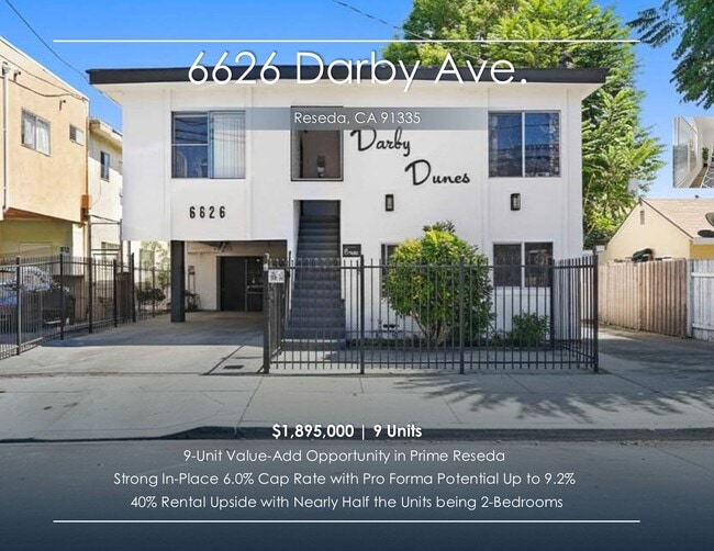


This Property Is For Sale
NEARBY LISTINGS FOR SALE OR LEASE
Property Detail
6626 Darby Ave
Los Angeles-Long Beach-Glendale, CA
1875
2125-017-010
TRACT # 1875 N 50 FT OF W 123.2 FT OF LOT 169
Multifamilydwelling
Los Angeles
X
California
06037C1285F
169
2024
0.14 AC
2025
Reseda
132700
Los Angeles
5,248 SF
DEMOGRAPHICS near 6626 Darby Ave
1 Mile
3 Mile
5 Mile
2024 Total Population
35,145
224,797
577,924
2029 Population
34,087
218,568
564,564
Pop Growth 2024-2029
(3.01%)
(2.77%)
(2.31%)
Average Age
40
41
40
2024 Total Households
11,873
76,506
200,808
HH Growth 2024-2029
(3.34%)
(3.00%)
(2.46%)
Median Household Inc
$66,199
$77,091
$77,286
Avg Household Size
2.80
2.80
2.80
2024 Avg HH Vehicles
2.00
2.00
2.00
Median Home Value
$695,157
$768,658
$785,750
Median Year Built
1970
1966
1970
Nearby Places
Map Layers
Map Styles
 Street
 Aerial
- Restaurants
- Banks
- Shops
- Fitness
- Groceries
PUBLIC TRANSPORTATION
COMMUTER RAIL
Northridge (Ventura County Line - Southern California Regional Rail Authority (Metrolink))
DRIVE
WALK
Distance
Northridge (Ventura County Line - Southern California Regional Rail Authority (Metrolink))
9 min
3.4 mi
DRIVE
WALK
Distance
8 min
3.5 mi
AIRPORT
Bob Hope
DRIVE
WALK
Distance
Bob Hope
25 min
11.3 mi
Los Angeles International
DRIVE
WALK
Distance
Los Angeles International
34 min
22.9 mi
Long Beach (Daugherty Field)
DRIVE
WALK
Distance
Long Beach (Daugherty Field)
52 min
40.4 mi
Freight Ports
Port of Long Beach
DRIVE
WALK
Distance
Port of Long Beach
55 min
42.5 mi
Nearby Properties
Address
Land Use
TOTAL SIZE
Lot Size
Zoning
Address
Land Use
TOTAL SIZE
Lot Size
Zoning
461,531 SF
11.22 AC
LAC2
Address
Land Use
TOTAL SIZE
Lot Size
Zoning
300,266 SF
7.29 AC
LAR4
Address
Land Use
TOTAL SIZE
Lot Size
Zoning
546,652 SF
4.27 AC
LAC2
Address
Land Use
TOTAL SIZE
Lot Size
Zoning
439,930 SF
22.16 AC
LAM2
Address
Land Use
TOTAL SIZE
Lot Size
Zoning
376,716 SF
3.72 AC
LAC4
Address
Land Use
TOTAL SIZE
Lot Size
Zoning
257,873 SF
2.52 AC
Address
Land Use
TOTAL SIZE
Lot Size
Zoning
191,058 SF
5.31 AC
LAR3
Address
Land Use
TOTAL SIZE
Lot Size
Zoning
273,911 SF
8.40 AC
LARA
Address
Land Use
TOTAL SIZE
Lot Size
Zoning
318,083 SF
2.36 AC
LAC2
Address
Land Use
TOTAL SIZE
Lot Size
Zoning
219,126 SF
6.06 AC
LAR1
Address
Land Use
TOTAL SIZE
Lot Size
Zoning
111,876 SF
3.72 AC
LAC2
Address
Land Use
TOTAL SIZE
Lot Size
Zoning
210,268 SF
3.82 AC
LAP
Address
Land Use
TOTAL SIZE
Lot Size
Zoning
117,604 SF
2.65 AC
LAR3
Address
Land Use
TOTAL SIZE
Lot Size
Zoning
173,231 SF
1.58 AC
LAR3
Address
Land Use
TOTAL SIZE
Lot Size
Zoning
138,260 SF
1.29 AC
LAC2
Address
Land Use
TOTAL SIZE
Lot Size
Zoning
250,462 SF
1.85 AC
LAP
Address
Land Use
TOTAL SIZE
Lot Size
Zoning
95,584 SF
4.27 AC
LAM1
Address
Land Use
TOTAL SIZE
Lot Size
Zoning
134,103 SF
1 AC
LAC2
Address
Land Use
TOTAL SIZE
Lot Size
Zoning
146,790 SF
1.85 AC
LAR3
Address
Land Use
TOTAL SIZE
Lot Size
Zoning
76,248 SF
1.21 AC
LAR3
Address
Land Use
TOTAL SIZE
Lot Size
Zoning
67,933 SF
0.93 AC
LAC2
Address
Land Use
TOTAL SIZE
Lot Size
Zoning
67,102 SF
1.72 AC
LAC4
Address
Land Use
TOTAL SIZE
Lot Size
Zoning
84,864 SF
2.39 AC
LAR3
Address
Land Use
TOTAL SIZE
Lot Size
Zoning
34,248 SF
1.64 AC
LARD5
Address
Land Use
TOTAL SIZE
Lot Size
Zoning
74,930 SF
2.01 AC
LAR3
Address
Land Use
TOTAL SIZE
Lot Size
Zoning
136,721 SF
3.44 AC
LARA
Address
Land Use
TOTAL SIZE
Lot Size
Zoning
40,729 SF
1.37 AC
LARA
Address
Land Use
TOTAL SIZE
Lot Size
Zoning
54,584 SF
0.69 AC
LACR
Address
Land Use
TOTAL SIZE
Lot Size
Zoning
288,501 SF
4.03 AC
LACR
Address
Land Use
TOTAL SIZE
Lot Size
Zoning
81,888 SF
1.01 AC
LAC2
The World's #1 Commercial Real Estate Marketplace
Connect with us
© 2025 CoStar Group
The information above has been obtained from sources believed reliable. While we do not doubt its accuracy we have not verified it and make no guarantee, warranty or representation about it. It is your responsibility to independently confirm its accuracy and completeness. Any projections, opinions, assumptions, or estimates used are for example only and do not represent the current or future performance of the property. The value of this transaction to you depends on tax and other factors which should be evaluated by your tax, financial, and legal advisors. You and your advisors should conduct a careful, independent investigation of the property to determine to your satisfaction the suitability of the property for your needs.