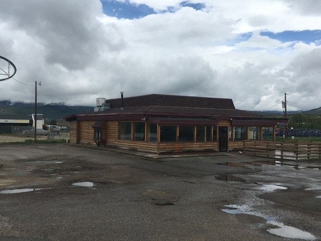
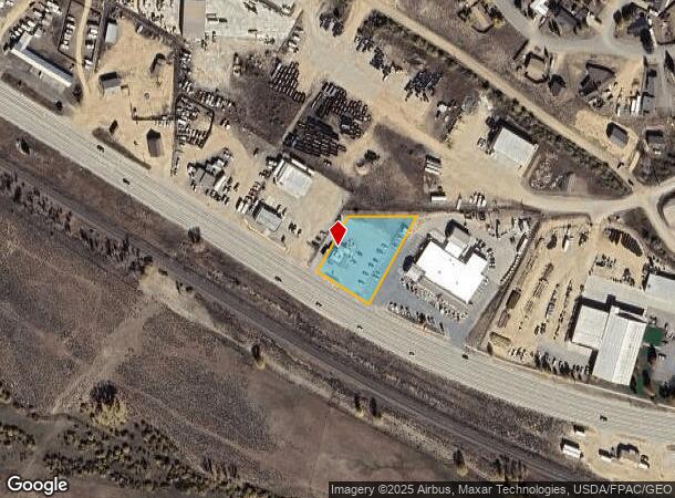
Property Record
663 W Agate Ave, Granby, CO 80446
Property Detail
663 W Agate Ave
R095360
Metes & Bounds 76 All
Officecondo
SUBD: METES & BOUNDS 76 ALL 0.823AC SE4SW4 SEC 31 T2N R76 DESC B/236 P/106
X
Grand
08049C0730C
Colorado
2025
9
2025
0.82 AC
000207
Colorado Ski Area
1,923 SF
Other Market Areas
NEARBY LISTINGS FOR SALE OR LEASE
DEMOGRAPHICS near 663 W Agate Ave
1 mile
3 mile
5 mile
2024 Total Population
1,664
3,222
3,395
2029 Population
1,640
3,139
3,309
Pop Growth 2024-2029
(1.44%)
(2.58%)
(2.53%)
Average Age
40
42
42
2024 Total Households
652
1,280
1,351
HH Growth 2024-2029
(2.15%)
(3.36%)
(3.33%)
Median Household Inc
$58,389
$63,750
$63,060
Avg Household Size
2.50
2.40
2.40
2024 Avg HH Vehicles
2.00
2.00
2.00
Median Home Value
$395,348
$358,208
$366,216
Median Year Built
1981
2000
2000
Nearby Places
Map Layers
Map Styles
 Street
 Aerial
Transit
 Traffic
 Biking
Places
Listings with unknown addresses are not visible on the map
- Restaurants
- Banks
- Shops
- Fitness
- Groceries
PUBLIC TRANSPORTATION
COMMUTER RAIL
Drive
Walk
Distance
2 min
18 min
0.9 mi
SALE & LEASE HISTORY
LISTING DATE
SALE/LEASE

Jun 27, 2019
For Lease
Nearby Properties
Address
Land Use
TOTAL SIZE
Lot Size
Zoning
Address
Land Use
TOTAL SIZE
Lot Size
Zoning
82,632 SF
10.22 AC
Address
Land Use
TOTAL SIZE
Lot Size
Zoning
121,034 SF
18.75 AC
Address
Land Use
TOTAL SIZE
Lot Size
Zoning
1,152 SF
28 AC
Address
Land Use
TOTAL SIZE
Lot Size
Zoning
54,927 SF
5.47 AC
Address
Land Use
TOTAL SIZE
Lot Size
Zoning
57,618 SF
5.63 AC
Address
Land Use
TOTAL SIZE
Lot Size
Zoning
4,460 SF
2.38 AC
Address
Land Use
TOTAL SIZE
Lot Size
Zoning
22,476 SF
1.69 AC
20
Address
Land Use
TOTAL SIZE
Lot Size
Zoning
12,359 SF
3.55 AC
20
Address
Land Use
TOTAL SIZE
Lot Size
Zoning
11,089 SF
0.79 AC
19
Address
Land Use
TOTAL SIZE
Lot Size
Zoning
1,456 SF
116.81 AC
Address
Land Use
TOTAL SIZE
Lot Size
Zoning
17,748 SF
3.38 AC
20
Address
Land Use
TOTAL SIZE
Lot Size
Zoning
106.09 AC
18
Address
Land Use
TOTAL SIZE
Lot Size
Zoning
18,016 SF
1.95 AC
20
Address
Land Use
TOTAL SIZE
Lot Size
Zoning
20,879 SF
0.81 AC
20
Address
Land Use
TOTAL SIZE
Lot Size
Zoning
18,222 SF
1.45 AC
19
Address
Land Use
TOTAL SIZE
Lot Size
Zoning
3,840 SF
2.42 AC
43
Address
Land Use
TOTAL SIZE
Lot Size
Zoning
9,106 SF
1.01 AC
20
Address
Land Use
TOTAL SIZE
Lot Size
Zoning
9,128 SF
0.63 AC
19
Address
Land Use
TOTAL SIZE
Lot Size
Zoning
6,431 SF
0.85 AC
20
Address
Land Use
TOTAL SIZE
Lot Size
Zoning
5,340 SF
1.55 AC
20
Address
Land Use
TOTAL SIZE
Lot Size
Zoning
5,176 SF
0.57 AC
20
Address
Land Use
TOTAL SIZE
Lot Size
Zoning
4,752 SF
0.84 AC
19
Address
Land Use
TOTAL SIZE
Lot Size
Zoning
6,810 SF
20.76 AC
9
Address
Land Use
TOTAL SIZE
Lot Size
Zoning
8,442 SF
12.68 AC
Address
Land Use
TOTAL SIZE
Lot Size
Zoning
10,816 SF
5.28 AC
Address
Land Use
TOTAL SIZE
Lot Size
Zoning
51,537 SF
2.14 AC
Address
Land Use
TOTAL SIZE
Lot Size
Zoning
580 SF
2 AC
Address
Land Use
TOTAL SIZE
Lot Size
Zoning
3,010 SF
2.82 AC
13
Address
Land Use
TOTAL SIZE
Lot Size
Zoning
9,980 SF
1.34 AC
The World's #1 Commercial Real Estate Marketplace
Connect with us
© 2026 CoStar Group
The information above has been obtained from sources believed reliable. While we do not doubt its accuracy we have not verified it and make no guarantee, warranty or representation about it. It is your responsibility to independently confirm its accuracy and completeness. Any projections, opinions, assumptions, or estimates used are for example only and do not represent the current or future performance of the property. The value of this transaction to you depends on tax and other factors which should be evaluated by your tax, financial, and legal advisors. You and your advisors should conduct a careful, independent investigation of the property to determine to your satisfaction the suitability of the property for your needs.