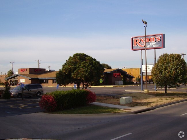
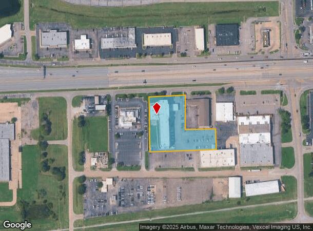
Property Record
6633 W Kellogg Dr, Wichita, KS 67209

NEARBY LISTINGS FOR SALE OR LEASE
Property Detail
6633 W Kellogg Dr
Wichita, KS
Branding Iron Add
138-27-0-31-01-002.00
LOT 1 EXC BEG NE COR THEREOF TH S 205.72 FT W 181.70 FT N 206.42 FT E 182.20 FT TO BEG BLOCK 1 BRANDING IRON ADD
Hotel
Sedgwick
X
Kansas
20173C0341G
1
2024
2.20 AC
2025
Goddard/West
009200
Wichita
55,001 SF
DEMOGRAPHICS near 6633 W Kellogg Dr
1 Mile
3 Mile
5 Mile
2024 Total Population
1,982
52,363
166,920
2029 Population
1,993
53,167
169,889
Pop Growth 2024-2029
+ 0.55%
+ 1.54%
+ 1.78%
Average Age
40
39
39
2024 Total Households
848
22,418
68,026
HH Growth 2024-2029
+ 0.59%
+ 1.55%
+ 1.88%
Median Household Inc
$48,090
$53,356
$57,843
Avg Household Size
2.20
2.20
2.30
2024 Avg HH Vehicles
2.00
2.00
2.00
Median Home Value
$180,323
$144,545
$158,826
Median Year Built
1981
1972
1974
Nearby Places
Map Layers
Map Styles
 Street
 Aerial
- Restaurants
- Banks
- Shops
- Fitness
- Groceries
PUBLIC TRANSPORTATION
AIRPORT
Wichita Dwight D Eisenhower Ntl
DRIVE
WALK
Distance
Wichita Dwight D Eisenhower Ntl
5 min
2.3 mi
Freight Ports
Tulsa Port Of Catoosa
DRIVE
WALK
Distance
Tulsa Port Of Catoosa
207 min
194.4 mi
Nearby Properties
Address
Land Use
TOTAL SIZE
Lot Size
Zoning
Address
Land Use
TOTAL SIZE
Lot Size
Zoning
1,675,141 SF
1,753.52 AC
LI
Address
Land Use
TOTAL SIZE
Lot Size
Zoning
456,792 SF
155.67 AC
LI
Address
Land Use
TOTAL SIZE
Lot Size
Zoning
303,559 SF
123.23 AC
SF-5
Address
Land Use
TOTAL SIZE
Lot Size
Zoning
203,580 SF
15.51 AC
B
Address
Land Use
TOTAL SIZE
Lot Size
Zoning
84,959 SF
2 AC
LI
Address
Land Use
TOTAL SIZE
Lot Size
Zoning
395,143 SF
3.58 AC
LI
Address
Land Use
TOTAL SIZE
Lot Size
Zoning
108,283 SF
14.80 AC
SF-5
Address
Land Use
TOTAL SIZE
Lot Size
Zoning
62,535 SF
8.34 AC
B
Address
Land Use
TOTAL SIZE
Lot Size
Zoning
169,321 SF
14.61 AC
U
Address
Land Use
TOTAL SIZE
Lot Size
Zoning
89,057 SF
18.91 AC
B
Address
Land Use
TOTAL SIZE
Lot Size
Zoning
35,097 SF
2.82 AC
U
Address
Land Use
TOTAL SIZE
Lot Size
Zoning
172,486 SF
25.68 AC
SF-5
Address
Land Use
TOTAL SIZE
Lot Size
Zoning
167,923 SF
18.01 AC
SF-5
Address
Land Use
TOTAL SIZE
Lot Size
Zoning
55,930 SF
10.28 AC
LI
Address
Land Use
TOTAL SIZE
Lot Size
Zoning
143,704 SF
19.22 AC
SF-5
Address
Land Use
TOTAL SIZE
Lot Size
Zoning
68,468 SF
7.17 AC
B,SF-5,GO
Address
Land Use
TOTAL SIZE
Lot Size
Zoning
136,717 SF
11.18 AC
SF-5
Address
Land Use
TOTAL SIZE
Lot Size
Zoning
1,677,015 SF
49.80 AC
LI,SF-20
Address
Land Use
TOTAL SIZE
Lot Size
Zoning
60,900 SF
281.77 AC
SF-5
Address
Land Use
TOTAL SIZE
Lot Size
Zoning
193,680 SF
4.31 AC
LI
Address
Land Use
TOTAL SIZE
Lot Size
Zoning
56,081 SF
3.75 AC
U
Address
Land Use
TOTAL SIZE
Lot Size
Zoning
56,519 SF
84.45 AC
SF-20,LI
Address
Land Use
TOTAL SIZE
Lot Size
Zoning
79,775 SF
7.94 AC
SF-5
Address
Land Use
TOTAL SIZE
Lot Size
Zoning
42,769 SF
3.09 AC
U
Address
Land Use
TOTAL SIZE
Lot Size
Zoning
58,392 SF
6.34 AC
LI
Address
Land Use
TOTAL SIZE
Lot Size
Zoning
65,504 SF
6.81 AC
SF-5
Address
Land Use
TOTAL SIZE
Lot Size
Zoning
62,321 SF
13.21 AC
SF-5
Address
Land Use
TOTAL SIZE
Lot Size
Zoning
52,262 SF
28.84 AC
B
Address
Land Use
TOTAL SIZE
Lot Size
Zoning
49,970 SF
110.38 AC
LI
Address
Land Use
TOTAL SIZE
Lot Size
Zoning
56,627 SF
14.01 AC
SF-5
The World's #1 Commercial Real Estate Marketplace
Connect with us
© 2026 CoStar Group
The information above has been obtained from sources believed reliable. While we do not doubt its accuracy we have not verified it and make no guarantee, warranty or representation about it. It is your responsibility to independently confirm its accuracy and completeness. Any projections, opinions, assumptions, or estimates used are for example only and do not represent the current or future performance of the property. The value of this transaction to you depends on tax and other factors which should be evaluated by your tax, financial, and legal advisors. You and your advisors should conduct a careful, independent investigation of the property to determine to your satisfaction the suitability of the property for your needs.