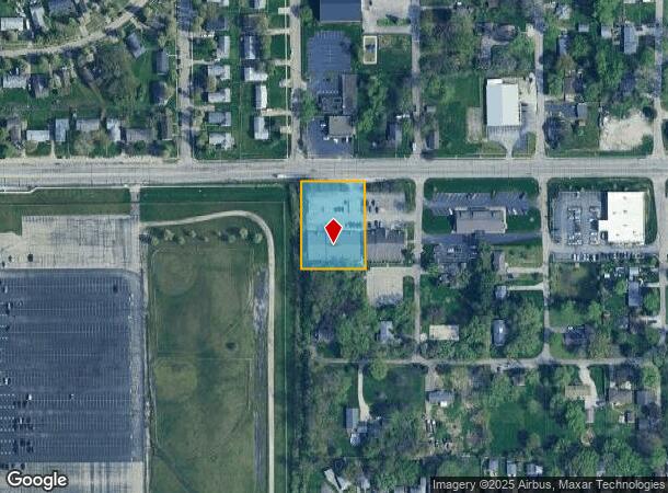
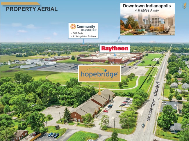
Property Record
6635 E 21St St, Indianapolis, IN 46219
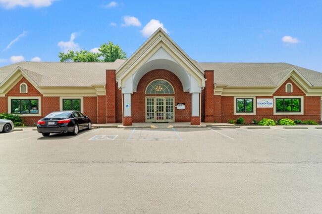
This Property Is For Sale
NEARBY LISTINGS FOR SALE OR LEASE
Property Detail
6635 E 21St St
49-07-35-116-005.000-774
PT NW1/4 NE1/4 S35 T16 R4 BEG NW COR P.O.B. S263 E176.31 N263 W175.61 TO BEG 1.065 AC
Officebuilding
Marion
X
Indiana
18097C0166F
1.07 AC
2023
Lawrence/East County
2024
Indianapolis
360800
Indianapolis-Carmel-Anderson, IN
10,140 SF
DEMOGRAPHICS near 6635 E 21St St
1 Mile
3 Mile
5 Mile
2024 Total Population
8,767
91,889
241,560
2029 Population
8,735
91,430
241,466
Pop Growth 2024-2029
(0.37%)
(0.50%)
(0.04%)
Average Age
39
38
37
2024 Total Households
3,608
37,891
97,555
HH Growth 2024-2029
(0.28%)
(0.59%)
(0.10%)
Median Household Inc
$32,564
$42,414
$44,465
Avg Household Size
2.20
2.30
2.40
2024 Avg HH Vehicles
1.00
1.00
1.00
Median Home Value
$97,089
$121,749
$141,994
Median Year Built
1958
1956
1961
Nearby Places
- Restaurants
- Banks
- Shops
- Fitness
- Groceries
PUBLIC TRANSPORTATION
COMMUTER RAIL
Indianapolis (Cardinal - Amtrak)
DRIVE
WALK
Distance
Indianapolis (Cardinal - Amtrak)
15 min
8.3 mi
AIRPORT
Indianapolis International
DRIVE
WALK
Distance
Indianapolis International
36 min
21.3 mi
Freight Ports
Port of Toledo
DRIVE
WALK
Distance
Port of Toledo
263 min
221.6 mi
Nearby Properties
Address
Land Use
TOTAL SIZE
Lot Size
Zoning
Address
Land Use
TOTAL SIZE
Lot Size
Zoning
1,202,700 SF
77.25 AC
ZO01
Address
Land Use
TOTAL SIZE
Lot Size
Zoning
25,146 SF
28.58 AC
ZO01
Address
Land Use
TOTAL SIZE
Lot Size
Zoning
47.10 AC
ZO01
Address
Land Use
TOTAL SIZE
Lot Size
Zoning
6,000 SF
8.79 AC
ZO01
Address
Land Use
TOTAL SIZE
Lot Size
Zoning
4,588 SF
24.33 AC
ZO01
Address
Land Use
TOTAL SIZE
Lot Size
Zoning
768,000 SF
29.62 AC
ZO03
Address
Land Use
TOTAL SIZE
Lot Size
Zoning
713,497 SF
69.91 AC
ZO01
Address
Land Use
TOTAL SIZE
Lot Size
Zoning
536,804 SF
25.94 AC
ZO01
Address
Land Use
TOTAL SIZE
Lot Size
Zoning
5,620 SF
36.95 AC
ZO01
Address
Land Use
TOTAL SIZE
Lot Size
Zoning
118,126 SF
6.31 AC
ZO01
Address
Land Use
TOTAL SIZE
Lot Size
Zoning
1,768 SF
30.88 AC
ZO01
Address
Land Use
TOTAL SIZE
Lot Size
Zoning
76,663 SF
1.91 AC
ZO01
Address
Land Use
TOTAL SIZE
Lot Size
Zoning
925,384 SF
49.48 AC
ZO01
Address
Land Use
TOTAL SIZE
Lot Size
Zoning
150,929 SF
28.61 AC
ZO01
Address
Land Use
TOTAL SIZE
Lot Size
Zoning
167,808 SF
14.95 AC
ZO01
Address
Land Use
TOTAL SIZE
Lot Size
Zoning
268,930 SF
20.55 AC
ZO01
Address
Land Use
TOTAL SIZE
Lot Size
Zoning
269,450 SF
5.85 AC
Address
Land Use
TOTAL SIZE
Lot Size
Zoning
1,865 SF
22.15 AC
ZO01
Address
Land Use
TOTAL SIZE
Lot Size
Zoning
8,054 SF
20.62 AC
Address
Land Use
TOTAL SIZE
Lot Size
Zoning
71,800 SF
1.88 AC
ZO01
Address
Land Use
TOTAL SIZE
Lot Size
Zoning
1,490 SF
14.21 AC
ZO01
Address
Land Use
TOTAL SIZE
Lot Size
Zoning
278,338 SF
14.80 AC
Address
Land Use
TOTAL SIZE
Lot Size
Zoning
206,080 SF
12.97 AC
ZO01
Address
Land Use
TOTAL SIZE
Lot Size
Zoning
175,046 SF
15.77 AC
ZO01
Address
Land Use
TOTAL SIZE
Lot Size
Zoning
254,641 SF
29.53 AC
Address
Land Use
TOTAL SIZE
Lot Size
Zoning
6,252 SF
17.02 AC
ZO01
Address
Land Use
TOTAL SIZE
Lot Size
Zoning
77,518 SF
11.69 AC
ZO01
Address
Land Use
TOTAL SIZE
Lot Size
Zoning
616,065 SF
51.20 AC
ZO01
Address
Land Use
TOTAL SIZE
Lot Size
Zoning
1,594 SF
6.47 AC
ZO01
Address
Land Use
TOTAL SIZE
Lot Size
Zoning
6.53 AC
ZO01
The World's #1 Commercial Real Estate Marketplace
Connect with us
© 2025 CoStar Group
The information above has been obtained from sources believed reliable. While we do not doubt its accuracy we have not verified it and make no guarantee, warranty or representation about it. It is your responsibility to independently confirm its accuracy and completeness. Any projections, opinions, assumptions, or estimates used are for example only and do not represent the current or future performance of the property. The value of this transaction to you depends on tax and other factors which should be evaluated by your tax, financial, and legal advisors. You and your advisors should conduct a careful, independent investigation of the property to determine to your satisfaction the suitability of the property for your needs.