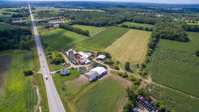
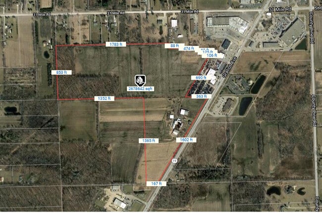
Property Record
66351 Gratiot Ave, Lenox, MI 48050
NEARBY LISTINGS FOR SALE OR LEASE
Property Detail
66351 Gratiot Ave
19-06-12-201-025
Gratiot
Agriculturalland
T4N,R14E SEC 12 SE 1/4 OF NW 1/4 40 ACRES
X
Macomb
26147C0425D
Michigan
2025
62.97 AC
2025
St Clair & Lapeer Counties
210000
Detroit
1,592 SF
Detroit-Warren-Dearborn, MI
DEMOGRAPHICS near 66351 Gratiot Ave
1 mile
3 mile
5 mile
2024 Total Population
1,889
8,361
21,018
2029 Population
1,870
8,251
20,915
Pop Growth 2024-2029
(1.01%)
(1.32%)
(0.49%)
Average Age
42
43
40
2024 Total Households
821
3,355
7,462
HH Growth 2024-2029
(1.10%)
(1.40%)
(0.62%)
Median Household Inc
$56,527
$71,169
$67,528
Avg Household Size
2.30
2.40
2.60
2024 Avg HH Vehicles
2.00
2.00
2.00
Median Home Value
$210,571
$242,992
$223,381
Median Year Built
1984
1981
1992
Nearby Places
Map Layers
Map Styles
 Street
 Aerial
Transit
 Traffic
 Biking
Places
Listings with unknown addresses are not visible on the map
- Restaurants
- Banks
- Shops
- Fitness
- Groceries
SALE & LEASE HISTORY
LISTING DATE
SALE/LEASE

Sep 26, 2018
For Sale
Sep 12, 2019
For Sale
Sep 11, 2019
For Sale
Oct 14, 2021
For Sale
Nov 23, 2017
For Sale
Nearby Properties
Address
Land Use
TOTAL SIZE
Lot Size
Zoning
Address
Land Use
TOTAL SIZE
Lot Size
Zoning
2,520 SF
712.24 AC
AG
Address
Land Use
TOTAL SIZE
Lot Size
Zoning
102,913 SF
B-3
Address
Land Use
TOTAL SIZE
Lot Size
Zoning
86,155 SF
17.46 AC
RM-1
Address
Land Use
TOTAL SIZE
Lot Size
Zoning
83,316 SF
11.93 AC
B-3
Address
Land Use
TOTAL SIZE
Lot Size
Zoning
218,105 SF
12.09 AC
I-1
Address
Land Use
TOTAL SIZE
Lot Size
Zoning
21,520 SF
5.54 AC
B-3
Address
Land Use
TOTAL SIZE
Lot Size
Zoning
10,297 SF
1.91 AC
AG
Address
Land Use
TOTAL SIZE
Lot Size
Zoning
20,070 SF
5 AC
CG
Address
Land Use
TOTAL SIZE
Lot Size
Zoning
50,854 SF
3.79 AC
RM-1
Address
Land Use
TOTAL SIZE
Lot Size
Zoning
64,565 SF
16.60 AC
IND20KSF
Address
Land Use
TOTAL SIZE
Lot Size
Zoning
37,807 SF
4.41 AC
B-3
Address
Land Use
TOTAL SIZE
Lot Size
Zoning
31,170 SF
8.16 AC
B-3
Address
Land Use
TOTAL SIZE
Lot Size
Zoning
99,504 SF
10.40 AC
B-3
Address
Land Use
TOTAL SIZE
Lot Size
Zoning
1,104 SF
79.25 AC
CG
Address
Land Use
TOTAL SIZE
Lot Size
Zoning
21,200 SF
22.25 AC
CG
Address
Land Use
TOTAL SIZE
Lot Size
Zoning
2,920 SF
47.73 AC
CN
Address
Land Use
TOTAL SIZE
Lot Size
Zoning
1,714 SF
5 AC
MORTUARIES
Address
Land Use
TOTAL SIZE
Lot Size
Zoning
27,754 SF
2.58 AC
RM-1
Address
Land Use
TOTAL SIZE
Lot Size
Zoning
26,479 SF
2.95 AC
RM-1
Address
Land Use
TOTAL SIZE
Lot Size
Zoning
25.07 AC
I-1
Address
Land Use
TOTAL SIZE
Lot Size
Zoning
91,910 SF
11.64 AC
B-3
Address
Land Use
TOTAL SIZE
Lot Size
Zoning
Address
Land Use
TOTAL SIZE
Lot Size
Zoning
17,995 SF
2.66 AC
O
Address
Land Use
TOTAL SIZE
Lot Size
Zoning
11,040 SF
152.52 AC
AG
Address
Land Use
TOTAL SIZE
Lot Size
Zoning
4,416 SF
52.54 AC
RLD
Address
Land Use
TOTAL SIZE
Lot Size
Zoning
27,616 SF
1.86 AC
RM-1
Address
Land Use
TOTAL SIZE
Lot Size
Zoning
30,000 SF
10 AC
INDUSTR
Address
Land Use
TOTAL SIZE
Lot Size
Zoning
21,420 SF
5.11 AC
RM-1
Address
Land Use
TOTAL SIZE
Lot Size
Zoning
13,367 SF
1.22 AC
B-3
Address
Land Use
TOTAL SIZE
Lot Size
Zoning
113.82 AC
AG
The World's #1 Commercial Real Estate Marketplace
Connect with us
© 2026 CoStar Group
The information above has been obtained from sources believed reliable. While we do not doubt its accuracy we have not verified it and make no guarantee, warranty or representation about it. It is your responsibility to independently confirm its accuracy and completeness. Any projections, opinions, assumptions, or estimates used are for example only and do not represent the current or future performance of the property. The value of this transaction to you depends on tax and other factors which should be evaluated by your tax, financial, and legal advisors. You and your advisors should conduct a careful, independent investigation of the property to determine to your satisfaction the suitability of the property for your needs.