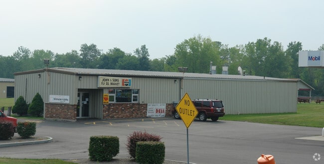
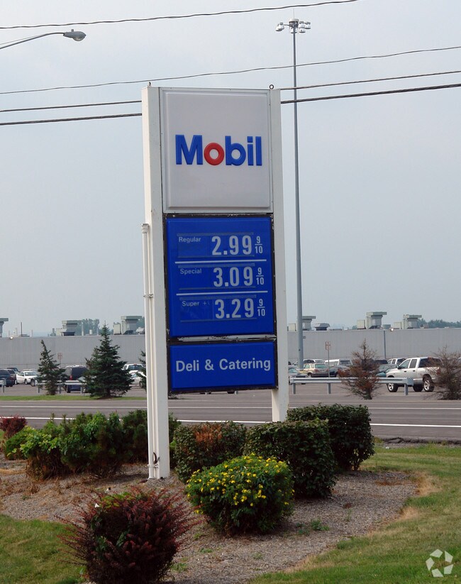
Property Record
6636 Fly Rd, East Syracuse, NY 13057
NEARBY LISTINGS FOR SALE OR LEASE
Property Detail
6636 Fly Rd
312689-029-000-0002-002-004-0000
FL 23
Storesoffices
Onondaga
X
New York
36067C0233F
2.004
2025
2.01 AC
2024
SE Outer Onondaga County
014500
Syracuse
4,070 SF
Syracuse, NY
DEMOGRAPHICS near 6636 Fly Rd
1 Mile
3 Mile
5 Mile
2024 Total Population
1,812
20,514
110,893
2029 Population
1,788
20,012
107,967
Pop Growth 2024-2029
(1.32%)
(2.45%)
(2.64%)
Average Age
44
42
40
2024 Total Households
768
9,100
47,516
HH Growth 2024-2029
(1.69%)
(2.68%)
(2.75%)
Median Household Inc
$78,919
$61,767
$58,638
Avg Household Size
2.30
2.20
2.20
2024 Avg HH Vehicles
2.00
2.00
1.00
Median Home Value
$171,496
$140,832
$148,941
Median Year Built
1965
1957
1954
Nearby Places
- Restaurants
- Banks
- Shops
- Fitness
- Groceries
PUBLIC TRANSPORTATION
COMMUTER RAIL
DRIVE
WALK
Distance
14 min
6.9 mi
DRIVE
WALK
Distance
14 min
6.9 mi
AIRPORT
Syracuse Hancock International
DRIVE
WALK
Distance
Syracuse Hancock International
18 min
8.3 mi
Nearby Properties
Address
Land Use
TOTAL SIZE
Lot Size
Zoning
Address
Land Use
TOTAL SIZE
Lot Size
Zoning
569,463 SF
94.77 AC
06 - INDUS
Address
Land Use
TOTAL SIZE
Lot Size
Zoning
80,845 SF
14.04 AC
06 - INDUS
Address
Land Use
TOTAL SIZE
Lot Size
Zoning
12,836 SF
148.95 AC
06 - INDUS
Address
Land Use
TOTAL SIZE
Lot Size
Zoning
116,580 SF
18.46 AC
06 - INDUS
Address
Land Use
TOTAL SIZE
Lot Size
Zoning
174,750 SF
10.40 AC
06 - INDUS
Address
Land Use
TOTAL SIZE
Lot Size
Zoning
104,400 SF
12.84 AC
06 - INDUS
Address
Land Use
TOTAL SIZE
Lot Size
Zoning
157,497 SF
14.56 AC
06 - INDUS
Address
Land Use
TOTAL SIZE
Lot Size
Zoning
145,588 SF
75.45 AC
RA
Address
Land Use
TOTAL SIZE
Lot Size
Zoning
5.39 AC
06 - INDUS
Address
Land Use
TOTAL SIZE
Lot Size
Zoning
47,122 SF
42.77 AC
06 - INDUS
Address
Land Use
TOTAL SIZE
Lot Size
Zoning
141,151 SF
20.23 AC
06 - INDUS
Address
Land Use
TOTAL SIZE
Lot Size
Zoning
110,105 SF
26.68 AC
06 - INDUS
Address
Land Use
TOTAL SIZE
Lot Size
Zoning
89,985 SF
11.37 AC
06 - INDUS
Address
Land Use
TOTAL SIZE
Lot Size
Zoning
160,767 SF
20.52 AC
05 - COMME
Address
Land Use
TOTAL SIZE
Lot Size
Zoning
2,025 SF
267.94 AC
06 - INDUS
Address
Land Use
TOTAL SIZE
Lot Size
Zoning
110,976 SF
42.31 AC
06 - INDUS
Address
Land Use
TOTAL SIZE
Lot Size
Zoning
165,954 SF
10.66 AC
06 - INDUS
Address
Land Use
TOTAL SIZE
Lot Size
Zoning
246,172 SF
16.65 AC
Address
Land Use
TOTAL SIZE
Lot Size
Zoning
32,840 SF
26.60 AC
05 - COMME
Address
Land Use
TOTAL SIZE
Lot Size
Zoning
150,216 SF
50.42 AC
RA
Address
Land Use
TOTAL SIZE
Lot Size
Zoning
38,595 SF
0.67 AC
06 - INDUS
Address
Land Use
TOTAL SIZE
Lot Size
Zoning
21,882 SF
13.56 AC
05 - COMME
Address
Land Use
TOTAL SIZE
Lot Size
Zoning
110,811 SF
11.46 AC
06 - INDUS
Address
Land Use
TOTAL SIZE
Lot Size
Zoning
70,668 SF
5.35 AC
05 - COMME
Address
Land Use
TOTAL SIZE
Lot Size
Zoning
116,224 SF
13.08 AC
05 - COMME
Address
Land Use
TOTAL SIZE
Lot Size
Zoning
69,910 SF
16.01 AC
06 - INDUS
Address
Land Use
TOTAL SIZE
Lot Size
Zoning
169,511 SF
4.25 AC
01 - NOT Z
Address
Land Use
TOTAL SIZE
Lot Size
Zoning
206,807 SF
46 AC
06 - INDUS
Address
Land Use
TOTAL SIZE
Lot Size
Zoning
169,505 SF
23.78 AC
06 - INDUS
Address
Land Use
TOTAL SIZE
Lot Size
Zoning
56,416 SF
18.27 AC
05 - COMME
The World's #1 Commercial Real Estate Marketplace
Connect with us
© 2025 CoStar Group
The information above has been obtained from sources believed reliable. While we do not doubt its accuracy we have not verified it and make no guarantee, warranty or representation about it. It is your responsibility to independently confirm its accuracy and completeness. Any projections, opinions, assumptions, or estimates used are for example only and do not represent the current or future performance of the property. The value of this transaction to you depends on tax and other factors which should be evaluated by your tax, financial, and legal advisors. You and your advisors should conduct a careful, independent investigation of the property to determine to your satisfaction the suitability of the property for your needs.