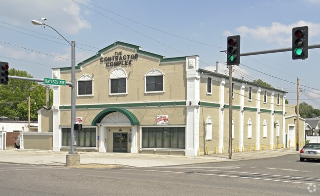
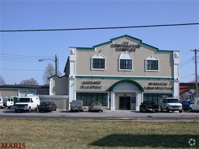
Property Record
664 Lemay Ferry Rd, Saint Louis, MO 63125


Property Detail
664 Lemay Ferry Rd
26G-11-1222
FROSTS ADDN TO LUXEMBURG LOT PTS 21 THRU 24
Officebuilding
ST. LOUIS
C2
Missouri
B and X Area of moderate flood hazard, usually the area between the limits of the 100-year and 500-year floods.
21-24
0
0.40 AC
2025
South County
220101
St. Louis
17,000 SF
St. Louis, MO-IL
NEARBY LISTINGS FOR SALE OR LEASE
DEMOGRAPHICS near 664 Lemay Ferry Rd
1 mile
3 mile
5 mile
2025 Total Population
12,319
92,095
237,799
2030 Population
12,128
88,661
228,894
Pop Growth 2025-2030
(1.55%)
(3.73%)
(3.74%)
Average Age
41
42
41
2025 Total Households
5,111
40,857
107,444
HH Growth 2025-2030
(1.68%)
(4.10%)
(4.18%)
Median Household Inc
$57,595
$67,209
$70,229
Avg Household Size
2.30
2.20
2.10
2025 Avg HH Vehicles
2.00
2.00
2.00
Median Home Value
$144,727
$179,359
$220,187
Median Year Built
1950
1952
1952
Nearby Places
Map Layers
Map Styles
 Street
 Aerial
Layers
 Traffic
 Biking
Places
Listings with unknown addresses are not visible on the map
- Restaurants
- Banks
- Shops
- Fitness
- Groceries
PUBLIC TRANSPORTATION
COMMUTER RAIL
Shrewsbury-Lansdowne (Shrewsbury-Lansdowne I-44 Emerson Park - St. Louis MetroLink (MetroLink))
Drive
Walk
Distance
Shrewsbury-Lansdowne (Shrewsbury-Lansdowne I-44 Emerson Park - St. Louis MetroLink (MetroLink))
11 min
5.2 mi
Sunnen (Shrewsbury-Lansdowne I-44 Emerson Park - St. Louis MetroLink (MetroLink))
Drive
Walk
Distance
Sunnen (Shrewsbury-Lansdowne I-44 Emerson Park - St. Louis MetroLink (MetroLink))
14 min
6.8 mi
AIRPORT
St Louis Lambert International
Drive
Walk
Distance
St Louis Lambert International
32 min
18.9 mi
Scott AFB/Midamerica St Louis
Drive
Walk
Distance
Scott AFB/Midamerica St Louis
50 min
33.9 mi
Freight Ports
Port Milwaukee
Drive
Walk
Distance
Port Milwaukee
429 min
378.2 mi
SALE & LEASE HISTORY
LISTING DATE
SALE/LEASE

Jul 08, 2022
For Sale
Nearby Properties
Address
Land Use
TOTAL SIZE
Lot Size
Zoning
Address
Land Use
TOTAL SIZE
Lot Size
Zoning
0.92 AC
A
Address
Land Use
TOTAL SIZE
Lot Size
Zoning
5.61 AC
A
Address
Land Use
TOTAL SIZE
Lot Size
Zoning
327,966 SF
56.80 AC
FPC8
Address
Land Use
TOTAL SIZE
Lot Size
Zoning
275,354 SF
72.71 AC
FPM2
Address
Land Use
TOTAL SIZE
Lot Size
Zoning
177.77 AC
A
Address
Land Use
TOTAL SIZE
Lot Size
Zoning
124,890 SF
11.91 AC
J
Address
Land Use
TOTAL SIZE
Lot Size
Zoning
3,835 SF
29.77 AC
R5
Address
Land Use
TOTAL SIZE
Lot Size
Zoning
391,268 SF
132.29 AC
R4
Address
Land Use
TOTAL SIZE
Lot Size
Zoning
40.60 AC
R4
Address
Land Use
TOTAL SIZE
Lot Size
Zoning
90,185 SF
407.16 AC
P5
Address
Land Use
TOTAL SIZE
Lot Size
Zoning
22.44 AC
A
Address
Land Use
TOTAL SIZE
Lot Size
Zoning
142,800 SF
13.38 AC
106PL1
Address
Land Use
TOTAL SIZE
Lot Size
Zoning
150,982 SF
18.74 AC
C-8
Address
Land Use
TOTAL SIZE
Lot Size
Zoning
261,362 SF
17.19 AC
R6
Address
Land Use
TOTAL SIZE
Lot Size
Zoning
185,035 SF
8.94 AC
106PL1
Address
Land Use
TOTAL SIZE
Lot Size
Zoning
20.27 AC
R5
Address
Land Use
TOTAL SIZE
Lot Size
Zoning
137,432 SF
9.18 AC
C3
Address
Land Use
TOTAL SIZE
Lot Size
Zoning
119,473 SF
8.65 AC
106PL1
Address
Land Use
TOTAL SIZE
Lot Size
Zoning
50.67 AC
A
Address
Land Use
TOTAL SIZE
Lot Size
Zoning
12.37 AC
R4
Address
Land Use
TOTAL SIZE
Lot Size
Zoning
17.93 AC
R5
Address
Land Use
TOTAL SIZE
Lot Size
Zoning
183,917 SF
12.89 AC
R6A
Address
Land Use
TOTAL SIZE
Lot Size
Zoning
267,886 SF
27.34 AC
R6
Address
Land Use
TOTAL SIZE
Lot Size
Zoning
121,875 SF
6.99 AC
106PL1
Address
Land Use
TOTAL SIZE
Lot Size
Zoning
219,361 SF
9.36 AC
M1
Address
Land Use
TOTAL SIZE
Lot Size
Zoning
9.33 AC
R5
Address
Land Use
TOTAL SIZE
Lot Size
Zoning
5.98 AC
R4
Address
Land Use
TOTAL SIZE
Lot Size
Zoning
928 SF
7.25 AC
R5
Address
Land Use
TOTAL SIZE
Lot Size
Zoning
134,787 SF
9.15 AC
106PL1
Address
Land Use
TOTAL SIZE
Lot Size
Zoning
15.97 AC
A
The World's #1 Commercial Real Estate Marketplace
Connect with us
© 2026 CoStar Group
The information above has been obtained from sources believed reliable. While we do not doubt its accuracy we have not verified it and make no guarantee, warranty or representation about it. It is your responsibility to independently confirm its accuracy and completeness. Any projections, opinions, assumptions, or estimates used are for example only and do not represent the current or future performance of the property. The value of this transaction to you depends on tax and other factors which should be evaluated by your tax, financial, and legal advisors. You and your advisors should conduct a careful, independent investigation of the property to determine to your satisfaction the suitability of the property for your needs.