Property Record
664 Stamps Rd, Merryville, LA 70653
Current Lease Availabilities
NEARBY LISTINGS FOR SALE OR LEASE
-
-
View all Merryville listings for lease on LoopNet.com
Property Detail
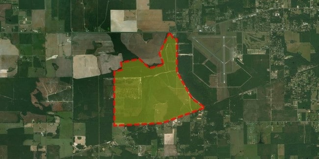
664 Stamps Rd
0201895975C
TOWNSHIP 3 SOUTH, RANGE 11 WEST SECTION 12: N/2 OF NE/4; SW/4 OF NE/4 LYING NORTH OF THE CENTERLINE OF STAMPS ROAD; W/2 LYING
Sfr
Beauregard
A
Louisiana
22115C0750E
212.78 AC
2025
Louisiana South Area
2025
Other Market Areas
960200
DeRidder, LA
6,250 SF
DEMOGRAPHICS near 664 Stamps Rd
1 Mile
3 Mile
5 Mile
2024 Total Population
107
652
1,608
2029 Population
108
659
1,623
Pop Growth 2024-2029
+ 0.93%
+ 1.07%
+ 0.93%
Average Age
41
42
42
2024 Total Households
42
260
641
HH Growth 2024-2029
+ 2.38%
+ 0.77%
+ 0.94%
Median Household Inc
$94,444
$80,706
$76,887
Avg Household Size
2.50
2.40
2.40
2024 Avg HH Vehicles
2.00
2.00
2.00
Median Home Value
$115,384
$102,055
$101,977
Median Year Built
1997
1991
1990
Nearby Places
Map Layers
Map Styles
 Street
 Aerial
- Restaurants
- Banks
- Shops
- Fitness
- Groceries
Nearby Properties
Address
Land Use
TOTAL SIZE
Lot Size
Zoning
Address
Land Use
TOTAL SIZE
Lot Size
Zoning
4,858 SF
320 AC
Address
Land Use
TOTAL SIZE
Lot Size
Zoning
4,268 SF
15.05 AC
Address
Land Use
TOTAL SIZE
Lot Size
Zoning
1,632 SF
89 AC
Address
Land Use
TOTAL SIZE
Lot Size
Zoning
3,358 SF
9.99 AC
Address
Land Use
TOTAL SIZE
Lot Size
Zoning
3,269 SF
3 AC
Address
Land Use
TOTAL SIZE
Lot Size
Zoning
3,936 SF
18.18 AC
Address
Land Use
TOTAL SIZE
Lot Size
Zoning
2,719 SF
4.84 AC
Address
Land Use
TOTAL SIZE
Lot Size
Zoning
3,681 SF
45.97 AC
Address
Land Use
TOTAL SIZE
Lot Size
Zoning
9.24 AC
Address
Land Use
TOTAL SIZE
Lot Size
Zoning
10.35 AC
Address
Land Use
TOTAL SIZE
Lot Size
Zoning
2,511 SF
16 AC
Address
Land Use
TOTAL SIZE
Lot Size
Zoning
2,236 SF
4.84 AC
Address
Land Use
TOTAL SIZE
Lot Size
Zoning
2,712 SF
8.53 AC
Address
Land Use
TOTAL SIZE
Lot Size
Zoning
2,560 SF
10 AC
Address
Land Use
TOTAL SIZE
Lot Size
Zoning
2,764 SF
5.35 AC
Address
Land Use
TOTAL SIZE
Lot Size
Zoning
2,168 SF
2 AC
Address
Land Use
TOTAL SIZE
Lot Size
Zoning
2,352 SF
9.18 AC
Address
Land Use
TOTAL SIZE
Lot Size
Zoning
2,438 SF
6.35 AC
Address
Land Use
TOTAL SIZE
Lot Size
Zoning
4,224 SF
40 AC
Address
Land Use
TOTAL SIZE
Lot Size
Zoning
1,710 SF
38.68 AC
Address
Land Use
TOTAL SIZE
Lot Size
Zoning
2,275 SF
2.50 AC
Address
Land Use
TOTAL SIZE
Lot Size
Zoning
2,581 SF
20.70 AC
Address
Land Use
TOTAL SIZE
Lot Size
Zoning
2,855 SF
2.50 AC
Address
Land Use
TOTAL SIZE
Lot Size
Zoning
2,742 SF
10 AC
Address
Land Use
TOTAL SIZE
Lot Size
Zoning
1,884 SF
4.84 AC
Address
Land Use
TOTAL SIZE
Lot Size
Zoning
2,620 SF
20 AC
Address
Land Use
TOTAL SIZE
Lot Size
Zoning
1,940 SF
10.07 AC
Address
Land Use
TOTAL SIZE
Lot Size
Zoning
2,272 SF
3 AC
Address
Land Use
TOTAL SIZE
Lot Size
Zoning
2,940 SF
10 AC
The World's #1 Commercial Real Estate Marketplace
Connect with us
© 2026 CoStar Group
The information above has been obtained from sources believed reliable. While we do not doubt its accuracy we have not verified it and make no guarantee, warranty or representation about it. It is your responsibility to independently confirm its accuracy and completeness. Any projections, opinions, assumptions, or estimates used are for example only and do not represent the current or future performance of the property. The value of this transaction to you depends on tax and other factors which should be evaluated by your tax, financial, and legal advisors. You and your advisors should conduct a careful, independent investigation of the property to determine to your satisfaction the suitability of the property for your needs.