Property Record
664 Valley Rd, Gillette, NJ 07933
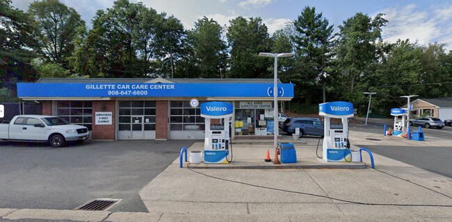

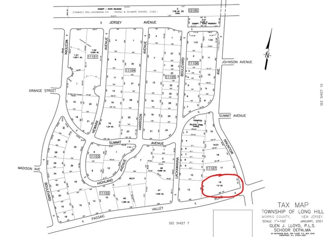
Property Detail
664 Valley Rd
Newark, NJ
Morris
30-11107-0000-00016
New Jersey
Servicestation
16
2024
1.20 AC
2025
Morristown Region
044102
Northern New Jersey
2,294 SF
NEARBY LISTINGS FOR SALE OR LEASE
DEMOGRAPHICS near 664 Valley Rd
1 mile
3 mile
5 mile
2025 Total Population
4,389
33,168
154,644
2030 Population
4,566
34,845
161,314
Pop Growth 2025-2030
+ 4.03%
+ 5.06%
+ 4.31%
Average Age
43
43
41
2025 Total Households
1,526
11,397
52,761
HH Growth 2025-2030
+ 4.00%
+ 5.10%
+ 4.44%
Median Household Inc
$185,456
$182,991
$127,948
Avg Household Size
2.90
2.90
2.80
2025 Avg HH Vehicles
2.00
2.00
2.00
Median Home Value
$759,528
$783,793
$689,424
Median Year Built
1966
1968
1962
Nearby Places
Map Layers
Map Styles
 Street
 Aerial
Transit
 Traffic
 Biking
Places
Listings with unknown addresses are not visible on the map
- Restaurants
- Banks
- Shops
- Fitness
- Groceries
PUBLIC TRANSPORTATION
COMMUTER RAIL
Gillette (Morris & Essex Gladstone Branch - NJ Transit Commuter Rail (NJ Transit))
Drive
Walk
Distance
Gillette (Morris & Essex Gladstone Branch - NJ Transit Commuter Rail (NJ Transit))
1 min
6 min
0.3 mi
Berkeley Heights (Morris & Essex Gladstone Branch - NJ Transit Commuter Rail (NJ Transit))
Drive
Walk
Distance
Berkeley Heights (Morris & Essex Gladstone Branch - NJ Transit Commuter Rail (NJ Transit))
2 min
1.6 mi
AIRPORT
Newark Liberty International
Drive
Walk
Distance
Newark Liberty International
27 min
21.0 mi
Freight Ports
New York Container Terminal
Drive
Walk
Distance
New York Container Terminal
37 min
24.0 mi
Nearby Properties
Address
Land Use
TOTAL SIZE
Lot Size
Zoning
Address
Land Use
TOTAL SIZE
Lot Size
Zoning
47.69 AC
MU
Address
Land Use
TOTAL SIZE
Lot Size
Zoning
34.27 AC
R65
Address
Land Use
TOTAL SIZE
Lot Size
Zoning
34.60 AC
MU
Address
Land Use
TOTAL SIZE
Lot Size
Zoning
67.22 AC
R65
Address
Land Use
TOTAL SIZE
Lot Size
Zoning
140,732 SF
42.73 AC
OR
Address
Land Use
TOTAL SIZE
Lot Size
Zoning
23.93 AC
B2
Address
Land Use
TOTAL SIZE
Lot Size
Zoning
24.92 AC
MU
Address
Land Use
TOTAL SIZE
Lot Size
Zoning
8.09 AC
B3
Address
Land Use
TOTAL SIZE
Lot Size
Zoning
6.76 AC
MU
Address
Land Use
TOTAL SIZE
Lot Size
Zoning
35.20 AC
OL
Address
Land Use
TOTAL SIZE
Lot Size
Zoning
9.53 AC
DD
Address
Land Use
TOTAL SIZE
Lot Size
Zoning
16.32 AC
R2
Address
Land Use
TOTAL SIZE
Lot Size
Zoning
11.16 AC
R-3
Address
Land Use
TOTAL SIZE
Lot Size
Zoning
7.46 AC
BR80
Address
Land Use
TOTAL SIZE
Lot Size
Zoning
30.26 AC
C
Address
Land Use
TOTAL SIZE
Lot Size
Zoning
21.30 AC
OL
Address
Land Use
TOTAL SIZE
Lot Size
Zoning
9.80 AC
OL
Address
Land Use
TOTAL SIZE
Lot Size
Zoning
4.42 AC
C
Address
Land Use
TOTAL SIZE
Lot Size
Zoning
55.80 AC
OL
Address
Land Use
TOTAL SIZE
Lot Size
Zoning
14.22 AC
B3
Address
Land Use
TOTAL SIZE
Lot Size
Zoning
2.30 AC
RMF3
Address
Land Use
TOTAL SIZE
Lot Size
Zoning
2.13 AC
RMF3
Address
Land Use
TOTAL SIZE
Lot Size
Zoning
Address
Land Use
TOTAL SIZE
Lot Size
Zoning
89,794 SF
10.19 AC
LI
Address
Land Use
TOTAL SIZE
Lot Size
Zoning
2.83 AC
NB
Address
Land Use
TOTAL SIZE
Lot Size
Zoning
51,000 SF
1.70 AC
LI
Address
Land Use
TOTAL SIZE
Lot Size
Zoning
8.98 AC
NB
Address
Land Use
TOTAL SIZE
Lot Size
Zoning
12.78 AC
CR
Address
Land Use
TOTAL SIZE
Lot Size
Zoning
23.25 AC
OL
Address
Land Use
TOTAL SIZE
Lot Size
Zoning
1,184 SF
2.99 AC
RBLR
The World's #1 Commercial Real Estate Marketplace
Connect with us
© 2026 CoStar Group
The information above has been obtained from sources believed reliable. While we do not doubt its accuracy we have not verified it and make no guarantee, warranty or representation about it. It is your responsibility to independently confirm its accuracy and completeness. Any projections, opinions, assumptions, or estimates used are for example only and do not represent the current or future performance of the property. The value of this transaction to you depends on tax and other factors which should be evaluated by your tax, financial, and legal advisors. You and your advisors should conduct a careful, independent investigation of the property to determine to your satisfaction the suitability of the property for your needs.