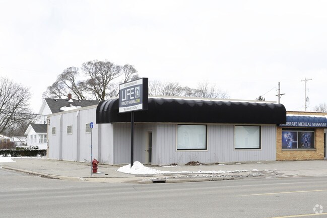
Property Record
6641 Division Ave S, Grand Rapids, MI 49548

Property Detail
6641 Division Ave S
41-21-01-478-024
LOT 7 BLK 2 EX N 0.9 FT OF W 47.03 FT OF E 71.53 FT * F. D. CUTLER PLAT
Commercialnec
Kent
B1
Michigan
C and X Area of minimal flood hazard, usually depicted on FIRMs as above the 500-year flood level.
7
2025
0.16 AC
2025
Byron/Gaines
014701
West Michigan
2,351 SF
Grand Rapids-Wyoming-Kentwood, MI
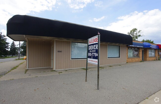
NEARBY LISTINGS FOR SALE OR LEASE
DEMOGRAPHICS near 6641 Division Ave S
1 mile
3 mile
5 mile
2025 Total Population
11,176
67,284
159,219
2030 Population
11,326
68,810
163,031
Pop Growth 2025-2030
+ 1.34%
+ 2.27%
+ 2.39%
Average Age
37
39
39
2025 Total Households
4,058
24,953
59,766
HH Growth 2025-2030
+ 1.43%
+ 2.39%
+ 2.46%
Median Household Inc
$64,179
$74,942
$76,607
Avg Household Size
2.70
2.60
2.60
2025 Avg HH Vehicles
2.00
2.00
2.00
Median Home Value
$92,851
$270,037
$273,247
Median Year Built
1987
1986
1983
Nearby Places
Map Layers
Map Styles
 Street
 Aerial
Layers
 Traffic
 Biking
Places
Listings with unknown addresses are not visible on the map
- Restaurants
- Banks
- Shops
- Fitness
- Groceries
PUBLIC TRANSPORTATION
COMMUTER RAIL
Drive
Walk
Distance
13 min
9.4 mi
AIRPORT
Gerald R Ford International
Drive
Walk
Distance
Gerald R Ford International
18 min
9.4 mi
Nearby Properties
Address
Land Use
TOTAL SIZE
Lot Size
Zoning
Address
Land Use
TOTAL SIZE
Lot Size
Zoning
290,627 SF
Address
Land Use
TOTAL SIZE
Lot Size
Zoning
490,769 SF
42.25 AC
B3
Address
Land Use
TOTAL SIZE
Lot Size
Zoning
295,027 SF
51.42 AC
I3
Address
Land Use
TOTAL SIZE
Lot Size
Zoning
63,788 SF
124.62 AC
D1
Address
Land Use
TOTAL SIZE
Lot Size
Zoning
48.43 AC
PUD-PL UNI
Address
Land Use
TOTAL SIZE
Lot Size
Zoning
487,739 SF
73.87 AC
RR
Address
Land Use
TOTAL SIZE
Lot Size
Zoning
26.94 AC
Address
Land Use
TOTAL SIZE
Lot Size
Zoning
Address
Land Use
TOTAL SIZE
Lot Size
Zoning
38.98 AC
PUD-PL UNI
Address
Land Use
TOTAL SIZE
Lot Size
Zoning
112,040 SF
9.69 AC
PUD3
Address
Land Use
TOTAL SIZE
Lot Size
Zoning
Address
Land Use
TOTAL SIZE
Lot Size
Zoning
386,450 SF
29.10 AC
Address
Land Use
TOTAL SIZE
Lot Size
Zoning
264,739 SF
26.56 AC
I2
Address
Land Use
TOTAL SIZE
Lot Size
Zoning
25.05 AC
R3-MED RES
Address
Land Use
TOTAL SIZE
Lot Size
Zoning
465,772 SF
61.95 AC
I1
Address
Land Use
TOTAL SIZE
Lot Size
Zoning
206,562 SF
15.12 AC
R1
Address
Land Use
TOTAL SIZE
Lot Size
Zoning
128,872 SF
7.32 AC
PUD3
Address
Land Use
TOTAL SIZE
Lot Size
Zoning
20.50 AC
RR
Address
Land Use
TOTAL SIZE
Lot Size
Zoning
2,593 SF
18 AC
PUD-PL UNI
Address
Land Use
TOTAL SIZE
Lot Size
Zoning
Address
Land Use
TOTAL SIZE
Lot Size
Zoning
158,240 SF
13.56 AC
R4
Address
Land Use
TOTAL SIZE
Lot Size
Zoning
349,885 SF
8.92 AC
I1
Address
Land Use
TOTAL SIZE
Lot Size
Zoning
229,572 SF
16.20 AC
PUD-PL UNI
Address
Land Use
TOTAL SIZE
Lot Size
Zoning
720 SF
74.47 AC
R4-MOBILE
Address
Land Use
TOTAL SIZE
Lot Size
Zoning
57,030 SF
17.74 AC
R3-MED RES
Address
Land Use
TOTAL SIZE
Lot Size
Zoning
50.15 AC
Address
Land Use
TOTAL SIZE
Lot Size
Zoning
203,567 SF
17.48 AC
I2
Address
Land Use
TOTAL SIZE
Lot Size
Zoning
54,259 SF
4.33 AC
PUD3
Address
Land Use
TOTAL SIZE
Lot Size
Zoning
108,911 SF
10.80 AC
D1
Address
Land Use
TOTAL SIZE
Lot Size
Zoning
132,600 SF
14 AC
R-PUD-1
The World's #1 Commercial Real Estate Marketplace
Connect with us
© 2026 CoStar Group
The information above has been obtained from sources believed reliable. While we do not doubt its accuracy we have not verified it and make no guarantee, warranty or representation about it. It is your responsibility to independently confirm its accuracy and completeness. Any projections, opinions, assumptions, or estimates used are for example only and do not represent the current or future performance of the property. The value of this transaction to you depends on tax and other factors which should be evaluated by your tax, financial, and legal advisors. You and your advisors should conduct a careful, independent investigation of the property to determine to your satisfaction the suitability of the property for your needs.