Property Record
6641 Monford Dr, Conover, NC 28613
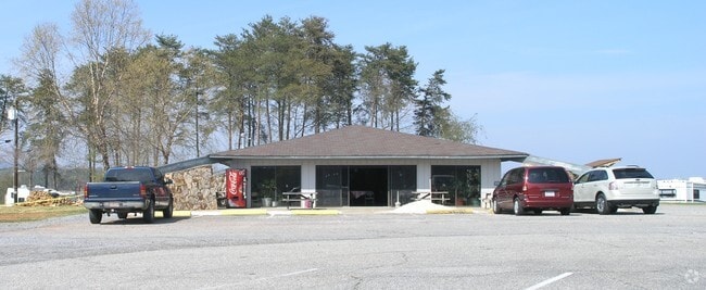


Property Detail
6641 Monford Dr
3735129528330000
PLAT 66-56
Storebuilding
Catawba
R-40
North Carolina
AE The base floodplain where base flood elevations are provided. AE Zones are now used on new format FIRMs instead of A1-A30 Zones.
23.11 AC
2024
Catawba County
2025
Charlotte
010201
Hickory-Lenoir-Morganton, NC
1,260 SF
NEARBY LISTINGS FOR SALE OR LEASE
-
-
View all Conover listings for sale on LoopNet.com
DEMOGRAPHICS near 6641 Monford Dr
1 mile
3 mile
5 mile
2025 Total Population
1,130
11,347
34,220
2030 Population
1,164
11,694
35,206
Pop Growth 2025-2030
+ 3.01%
+ 3.06%
+ 2.88%
Average Age
43
42
42
2025 Total Households
451
4,420
13,402
HH Growth 2025-2030
+ 3.10%
+ 3.08%
+ 2.95%
Median Household Inc
$72,783
$67,090
$65,923
Avg Household Size
2.40
2.50
2.50
2025 Avg HH Vehicles
3.00
3.00
2.00
Median Home Value
$344,736
$304,718
$269,695
Median Year Built
1987
1989
1988
Nearby Places
Map Layers
Map Styles
 Street
 Aerial
Layers
 Traffic
 Biking
Places
Listings with unknown addresses are not visible on the map
- Restaurants
- Banks
- Shops
- Fitness
- Groceries
Nearby Properties
Address
Land Use
TOTAL SIZE
Lot Size
Zoning
Address
Land Use
TOTAL SIZE
Lot Size
Zoning
28.97 AC
R-20
Address
Land Use
TOTAL SIZE
Lot Size
Zoning
12,416 SF
228.56 AC
R-2
Address
Land Use
TOTAL SIZE
Lot Size
Zoning
63,179 SF
40 AC
R20
Address
Land Use
TOTAL SIZE
Lot Size
Zoning
11.04 AC
R-20
Address
Land Use
TOTAL SIZE
Lot Size
Zoning
2,282 SF
450.95 AC
R-40
Address
Land Use
TOTAL SIZE
Lot Size
Zoning
1,369 SF
78.96 AC
RA20
Address
Land Use
TOTAL SIZE
Lot Size
Zoning
15,000 SF
6.78 AC
PD
Address
Land Use
TOTAL SIZE
Lot Size
Zoning
14,154 SF
2.40 AC
R-20
Address
Land Use
TOTAL SIZE
Lot Size
Zoning
14,893 SF
5.21 AC
RA20
Address
Land Use
TOTAL SIZE
Lot Size
Zoning
6,000 SF
4 AC
RA20
Address
Land Use
TOTAL SIZE
Lot Size
Zoning
30.50 AC
R-40
Address
Land Use
TOTAL SIZE
Lot Size
Zoning
9,173 SF
1.63 AC
RC
Address
Land Use
TOTAL SIZE
Lot Size
Zoning
4,154 SF
0.57 AC
HC
Address
Land Use
TOTAL SIZE
Lot Size
Zoning
4,106 SF
1.78 AC
R-40
Address
Land Use
TOTAL SIZE
Lot Size
Zoning
3,360 SF
3.36 AC
HC
Address
Land Use
TOTAL SIZE
Lot Size
Zoning
19.76 AC
RA20
Address
Land Use
TOTAL SIZE
Lot Size
Zoning
1,612 SF
2.14 AC
PD
Address
Land Use
TOTAL SIZE
Lot Size
Zoning
1,636 SF
1.27 AC
R-20
Address
Land Use
TOTAL SIZE
Lot Size
Zoning
3,623 SF
1.77 AC
R20
Address
Land Use
TOTAL SIZE
Lot Size
Zoning
52,801 SF
2 AC
LI
Address
Land Use
TOTAL SIZE
Lot Size
Zoning
9,020 SF
0.94 AC
RC
Address
Land Use
TOTAL SIZE
Lot Size
Zoning
35.60 AC
R-20
Address
Land Use
TOTAL SIZE
Lot Size
Zoning
6.57 AC
R-40
Address
Land Use
TOTAL SIZE
Lot Size
Zoning
1,728 SF
5.38 AC
R-20
Address
Land Use
TOTAL SIZE
Lot Size
Zoning
3,220 SF
0.39 AC
R-2
Address
Land Use
TOTAL SIZE
Lot Size
Zoning
2,591 SF
0.75 AC
R-2
Address
Land Use
TOTAL SIZE
Lot Size
Zoning
17.63 AC
R20
Address
Land Use
TOTAL SIZE
Lot Size
Zoning
14,544 SF
1.45 AC
HC
Address
Land Use
TOTAL SIZE
Lot Size
Zoning
6.03 AC
R-40
The World's #1 Commercial Real Estate Marketplace
Connect with us
© 2026 CoStar Group
The information above has been obtained from sources believed reliable. While we do not doubt its accuracy we have not verified it and make no guarantee, warranty or representation about it. It is your responsibility to independently confirm its accuracy and completeness. Any projections, opinions, assumptions, or estimates used are for example only and do not represent the current or future performance of the property. The value of this transaction to you depends on tax and other factors which should be evaluated by your tax, financial, and legal advisors. You and your advisors should conduct a careful, independent investigation of the property to determine to your satisfaction the suitability of the property for your needs.