Property Record
665 Route 33 E, Hightstown, NJ 08520


Property Detail
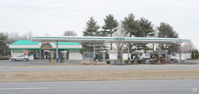
665 Route 33 E
01-00014-0000-00978
HESS
Storebuilding
MERCER
PUD
New Jersey
B and X Area of moderate flood hazard, usually the area between the limits of the 100-year and 500-year floods.
978
2024
0.62 AC
2025
Trenton
004403
Northern New Jersey
1,760 SF
Trenton-Princeton, NJ
NEARBY LISTINGS FOR SALE OR LEASE
DEMOGRAPHICS near 665 Route 33 E
1 mile
3 mile
5 mile
2025 Total Population
10,696
40,732
73,240
2030 Population
11,112
42,384
75,808
Pop Growth 2025-2030
+ 3.89%
+ 4.06%
+ 3.51%
Average Age
40
42
47
2025 Total Households
3,679
14,485
29,425
HH Growth 2025-2030
+ 3.94%
+ 4.00%
+ 3.53%
Median Household Inc
$105,682
$121,733
$103,482
Avg Household Size
2.80
2.70
2.40
2025 Avg HH Vehicles
2.00
2.00
2.00
Median Home Value
$347,469
$540,414
$472,146
Median Year Built
1976
1985
1983
Nearby Places
Map Layers
Map Styles
 Street
 Aerial
Transit
 Traffic
 Biking
Places
Listings with unknown addresses are not visible on the map
- Restaurants
- Banks
- Shops
- Fitness
- Groceries
PUBLIC TRANSPORTATION
COMMUTER RAIL
Princeton Junction (Northeast Corridor Line - NJ Transit Commuter Rail (NJ Transit), Princeton Branch - NJ Transit Commuter Rail (NJ Transit))
Drive
Walk
Distance
Princeton Junction (Northeast Corridor Line - NJ Transit Commuter Rail (NJ Transit), Princeton Branch - NJ Transit Commuter Rail (NJ Transit))
16 min
9.1 mi
AIRPORT
Trenton Mercer
Drive
Walk
Distance
Trenton Mercer
36 min
22.4 mi
Newark Liberty International
Drive
Walk
Distance
Newark Liberty International
54 min
41.6 mi
Freight Ports
New York Container Terminal
Drive
Walk
Distance
New York Container Terminal
47 min
36.6 mi
SALE & LEASE HISTORY
LISTING DATE
SALE/LEASE

Oct 26, 2023
For Sale
Nearby Properties
Address
Land Use
TOTAL SIZE
Lot Size
Zoning
Address
Land Use
TOTAL SIZE
Lot Size
Zoning
203.85 AC
I/LI
Address
Land Use
TOTAL SIZE
Lot Size
Zoning
57.09 AC
R-1
Address
Land Use
TOTAL SIZE
Lot Size
Zoning
115.37 AC
I/LI
Address
Land Use
TOTAL SIZE
Lot Size
Zoning
51.01 AC
RO
Address
Land Use
TOTAL SIZE
Lot Size
Zoning
47.51 AC
I/LI
Address
Land Use
TOTAL SIZE
Lot Size
Zoning
83.35 AC
I/LA
Address
Land Use
TOTAL SIZE
Lot Size
Zoning
2,338 SF
58.26 AC
I/LI
Address
Land Use
TOTAL SIZE
Lot Size
Zoning
376,379 SF
81.40 AC
PRC
Address
Land Use
TOTAL SIZE
Lot Size
Zoning
606,000 SF
51.49 AC
PUD
Address
Land Use
TOTAL SIZE
Lot Size
Zoning
12.30 AC
R-1
Address
Land Use
TOTAL SIZE
Lot Size
Zoning
69.94 AC
ILIS
Address
Land Use
TOTAL SIZE
Lot Size
Zoning
27.57 AC
PUD
Address
Land Use
TOTAL SIZE
Lot Size
Zoning
46.04 AC
I/LI
Address
Land Use
TOTAL SIZE
Lot Size
Zoning
196,499 SF
29.83 AC
HC
Address
Land Use
TOTAL SIZE
Lot Size
Zoning
243,700 SF
34.78 AC
HC
Address
Land Use
TOTAL SIZE
Lot Size
Zoning
53.56 AC
I/LI
Address
Land Use
TOTAL SIZE
Lot Size
Zoning
15 AC
PUD
Address
Land Use
TOTAL SIZE
Lot Size
Zoning
35.33 AC
LI
Address
Land Use
TOTAL SIZE
Lot Size
Zoning
22.13 AC
PUD
Address
Land Use
TOTAL SIZE
Lot Size
Zoning
153,230 SF
12.30 AC
HC
Address
Land Use
TOTAL SIZE
Lot Size
Zoning
130,233 SF
16.02 AC
HC
Address
Land Use
TOTAL SIZE
Lot Size
Zoning
8.93 AC
PUD
Address
Land Use
TOTAL SIZE
Lot Size
Zoning
22.47 AC
RO
Address
Land Use
TOTAL SIZE
Lot Size
Zoning
21.81 AC
RO
Address
Land Use
TOTAL SIZE
Lot Size
Zoning
25.53 AC
I/LI
Address
Land Use
TOTAL SIZE
Lot Size
Zoning
7.50 AC
R-4
Address
Land Use
TOTAL SIZE
Lot Size
Zoning
12.33 AC
PAC
Address
Land Use
TOTAL SIZE
Lot Size
Zoning
100,159 SF
30.46 AC
R60
Address
Land Use
TOTAL SIZE
Lot Size
Zoning
11.30 AC
R-3
Address
Land Use
TOTAL SIZE
Lot Size
Zoning
138,000 SF
7.92 AC
TC
The World's #1 Commercial Real Estate Marketplace
Connect with us
© 2026 CoStar Group
The information above has been obtained from sources believed reliable. While we do not doubt its accuracy we have not verified it and make no guarantee, warranty or representation about it. It is your responsibility to independently confirm its accuracy and completeness. Any projections, opinions, assumptions, or estimates used are for example only and do not represent the current or future performance of the property. The value of this transaction to you depends on tax and other factors which should be evaluated by your tax, financial, and legal advisors. You and your advisors should conduct a careful, independent investigation of the property to determine to your satisfaction the suitability of the property for your needs.