Property Record
665 U S Grant St, Lagrange, OH 44050
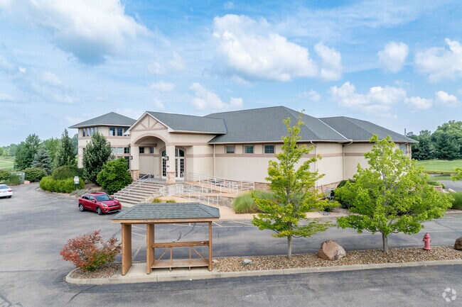


Property Detail
665 U S Grant St
Cleveland-Elyria, OH
GREYHAWK AT DURHAM RIDGE2 BLK E
15-00-034-000-103
Lorain
Golfcourse
Ohio
B and X Area of moderate flood hazard, usually the area between the limits of the 100-year and 500-year floods.
blk e
2024
3.67 AC
2024
Lorain County
094102
Cleveland
6,897 SF
NEARBY LISTINGS FOR SALE OR LEASE
DEMOGRAPHICS near 665 U S Grant St
1 mile
3 mile
5 mile
2025 Total Population
1,627
7,576
18,433
2030 Population
1,674
7,734
18,823
Pop Growth 2025-2030
+ 2.89%
+ 2.09%
+ 2.12%
Average Age
41
44
44
2025 Total Households
612
2,669
6,406
HH Growth 2025-2030
+ 2.94%
+ 2.21%
+ 2.28%
Median Household Inc
$97,332
$102,927
$98,790
Avg Household Size
2.60
2.60
2.50
2025 Avg HH Vehicles
2.00
2.00
2.00
Median Home Value
$282,432
$284,627
$280,896
Median Year Built
1991
1983
1978
Nearby Places
Map Layers
Map Styles
 Street
 Aerial
Layers
 Traffic
 Biking
Places
Listings with unknown addresses are not visible on the map
- Restaurants
- Banks
- Shops
- Fitness
- Groceries
PUBLIC TRANSPORTATION
AIRPORT
Cleveland-Hopkins International
Drive
Walk
Distance
Cleveland-Hopkins International
37 min
23.3 mi
Nearby Properties
Address
Land Use
TOTAL SIZE
Lot Size
Zoning
Address
Land Use
TOTAL SIZE
Lot Size
Zoning
242,218 SF
58.63 AC
Address
Land Use
TOTAL SIZE
Lot Size
Zoning
62,653 SF
10 AC
Address
Land Use
TOTAL SIZE
Lot Size
Zoning
15,200 SF
9.50 AC
Address
Land Use
TOTAL SIZE
Lot Size
Zoning
12,005 SF
5.66 AC
Address
Land Use
TOTAL SIZE
Lot Size
Zoning
10,126 SF
7.47 AC
Address
Land Use
TOTAL SIZE
Lot Size
Zoning
10,480 SF
0.50 AC
Address
Land Use
TOTAL SIZE
Lot Size
Zoning
2,112 SF
72.85 AC
Address
Land Use
TOTAL SIZE
Lot Size
Zoning
7,416 SF
6.36 AC
Address
Land Use
TOTAL SIZE
Lot Size
Zoning
62,040 SF
9.62 AC
Address
Land Use
TOTAL SIZE
Lot Size
Zoning
14,804 SF
1.97 AC
Address
Land Use
TOTAL SIZE
Lot Size
Zoning
25,022 SF
5.39 AC
Address
Land Use
TOTAL SIZE
Lot Size
Zoning
104,257 SF
16.86 AC
Address
Land Use
TOTAL SIZE
Lot Size
Zoning
7.18 AC
Address
Land Use
TOTAL SIZE
Lot Size
Zoning
51,998 SF
9.01 AC
Address
Land Use
TOTAL SIZE
Lot Size
Zoning
28,598 SF
6 AC
Address
Land Use
TOTAL SIZE
Lot Size
Zoning
3,672 SF
1.71 AC
Address
Land Use
TOTAL SIZE
Lot Size
Zoning
13,858 SF
0.11 AC
Address
Land Use
TOTAL SIZE
Lot Size
Zoning
4,257 SF
0.29 AC
Address
Land Use
TOTAL SIZE
Lot Size
Zoning
44,900 SF
6.05 AC
Address
Land Use
TOTAL SIZE
Lot Size
Zoning
9,180 SF
7.66 AC
Address
Land Use
TOTAL SIZE
Lot Size
Zoning
47,576 SF
1.02 AC
Address
Land Use
TOTAL SIZE
Lot Size
Zoning
1,600 SF
64.44 AC
Address
Land Use
TOTAL SIZE
Lot Size
Zoning
26,640 SF
3.69 AC
Address
Land Use
TOTAL SIZE
Lot Size
Zoning
43,817 SF
13.63 AC
Address
Land Use
TOTAL SIZE
Lot Size
Zoning
9,363 SF
0.20 AC
Address
Land Use
TOTAL SIZE
Lot Size
Zoning
42,473 SF
4.55 AC
Address
Land Use
TOTAL SIZE
Lot Size
Zoning
5,486 SF
1.92 AC
Address
Land Use
TOTAL SIZE
Lot Size
Zoning
3,912 SF
120.90 AC
Address
Land Use
TOTAL SIZE
Lot Size
Zoning
0.87 AC
Address
Land Use
TOTAL SIZE
Lot Size
Zoning
5,176 SF
0.31 AC
The World's #1 Commercial Real Estate Marketplace
Connect with us
© 2026 CoStar Group
The information above has been obtained from sources believed reliable. While we do not doubt its accuracy we have not verified it and make no guarantee, warranty or representation about it. It is your responsibility to independently confirm its accuracy and completeness. Any projections, opinions, assumptions, or estimates used are for example only and do not represent the current or future performance of the property. The value of this transaction to you depends on tax and other factors which should be evaluated by your tax, financial, and legal advisors. You and your advisors should conduct a careful, independent investigation of the property to determine to your satisfaction the suitability of the property for your needs.