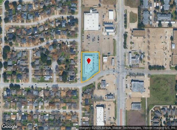
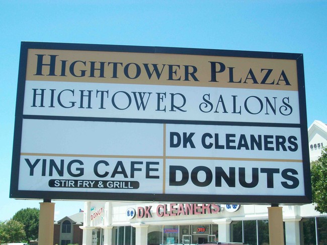
Property Record
6651 Hightower Dr, Watauga, TX 76148


NEARBY LISTINGS FOR SALE OR LEASE
Property Detail
6651 Hightower Dr
Dallas-Fort Worth-Arlington, TX
Summer Hills Addition
06098673
SUMMER HILLS ADDITION BLOCK 3 LOT 1A
Commercialnec
Tarrant
X
Texas
48439C0090L
1a
2024
1.44 AC
2025
Watauga/Keller/NRH
113808
Dallas/Ft Worth
16,472 SF
DEMOGRAPHICS near 6651 Hightower Dr
1 Mile
3 Mile
5 Mile
2024 Total Population
17,298
129,398
304,715
2029 Population
18,042
135,838
320,329
Pop Growth 2024-2029
+ 4.30%
+ 4.98%
+ 5.12%
Average Age
39
39
38
2024 Total Households
6,211
46,450
111,230
HH Growth 2024-2029
+ 4.30%
+ 5.07%
+ 5.23%
Median Household Inc
$81,659
$87,595
$87,506
Avg Household Size
2.80
2.70
2.70
2024 Avg HH Vehicles
2.00
2.00
2.00
Median Home Value
$231,769
$275,009
$291,136
Median Year Built
1983
1990
1992
Nearby Places
Map Layers
Map Styles
 Street
 Aerial
- Restaurants
- Banks
- Shops
- Fitness
- Groceries
PUBLIC TRANSPORTATION
COMMUTER RAIL
DRIVE
WALK
Distance
13 min
6.9 mi
Richland Hills (Trinity Railway Express - Dallas Area Rapid Transit (DART))
DRIVE
WALK
Distance
Richland Hills (Trinity Railway Express - Dallas Area Rapid Transit (DART))
13 min
7.4 mi
AIRPORT
Dallas-Fort Worth International
DRIVE
WALK
Distance
Dallas-Fort Worth International
29 min
19.5 mi
Dallas Love Field
DRIVE
WALK
Distance
Dallas Love Field
39 min
28.1 mi
Nearby Properties
Address
Land Use
TOTAL SIZE
Lot Size
Zoning
Address
Land Use
TOTAL SIZE
Lot Size
Zoning
547,836 SF
2 AC
Address
Land Use
TOTAL SIZE
Lot Size
Zoning
285,754 SF
69.41 AC
Address
Land Use
TOTAL SIZE
Lot Size
Zoning
381,000 SF
8.74 AC
Address
Land Use
TOTAL SIZE
Lot Size
Zoning
350,153 SF
19.73 AC
Address
Land Use
TOTAL SIZE
Lot Size
Zoning
388,447 SF
9.47 AC
Address
Land Use
TOTAL SIZE
Lot Size
Zoning
327,325 SF
16.87 AC
Address
Land Use
TOTAL SIZE
Lot Size
Zoning
285,672 SF
19.20 AC
Address
Land Use
TOTAL SIZE
Lot Size
Zoning
368,751 SF
19.97 AC
Address
Land Use
TOTAL SIZE
Lot Size
Zoning
301,972 SF
19.32 AC
Address
Land Use
TOTAL SIZE
Lot Size
Zoning
261,579 SF
30.93 AC
Address
Land Use
TOTAL SIZE
Lot Size
Zoning
930,000 SF
99.51 AC
Address
Land Use
TOTAL SIZE
Lot Size
Zoning
307,568 SF
13.13 AC
Address
Land Use
TOTAL SIZE
Lot Size
Zoning
248,166 SF
12.05 AC
Address
Land Use
TOTAL SIZE
Lot Size
Zoning
235,530 SF
13.21 AC
Address
Land Use
TOTAL SIZE
Lot Size
Zoning
221,591 SF
14.50 AC
Address
Land Use
TOTAL SIZE
Lot Size
Zoning
245,684 SF
18.11 AC
Address
Land Use
TOTAL SIZE
Lot Size
Zoning
187,236 SF
9.85 AC
Address
Land Use
TOTAL SIZE
Lot Size
Zoning
130,253 SF
17.92 AC
Address
Land Use
TOTAL SIZE
Lot Size
Zoning
176,242 SF
11.59 AC
Address
Land Use
TOTAL SIZE
Lot Size
Zoning
195,678 SF
12.24 AC
Address
Land Use
TOTAL SIZE
Lot Size
Zoning
197,860 SF
19.82 AC
Address
Land Use
TOTAL SIZE
Lot Size
Zoning
174,898 SF
10.28 AC
Address
Land Use
TOTAL SIZE
Lot Size
Zoning
132,145 SF
12.26 AC
Address
Land Use
TOTAL SIZE
Lot Size
Zoning
204,948 SF
23.93 AC
Address
Land Use
TOTAL SIZE
Lot Size
Zoning
350,000 SF
26.71 AC
Address
Land Use
TOTAL SIZE
Lot Size
Zoning
208,143 SF
24.87 AC
Address
Land Use
TOTAL SIZE
Lot Size
Zoning
170,983 SF
11.42 AC
Address
Land Use
TOTAL SIZE
Lot Size
Zoning
90,884 SF
10.85 AC
Address
Land Use
TOTAL SIZE
Lot Size
Zoning
181,988 SF
8.10 AC
Address
Land Use
TOTAL SIZE
Lot Size
Zoning
195,085 SF
8.81 AC
The World's #1 Commercial Real Estate Marketplace
Connect with us
© 2026 CoStar Group
The information above has been obtained from sources believed reliable. While we do not doubt its accuracy we have not verified it and make no guarantee, warranty or representation about it. It is your responsibility to independently confirm its accuracy and completeness. Any projections, opinions, assumptions, or estimates used are for example only and do not represent the current or future performance of the property. The value of this transaction to you depends on tax and other factors which should be evaluated by your tax, financial, and legal advisors. You and your advisors should conduct a careful, independent investigation of the property to determine to your satisfaction the suitability of the property for your needs.