Property Record
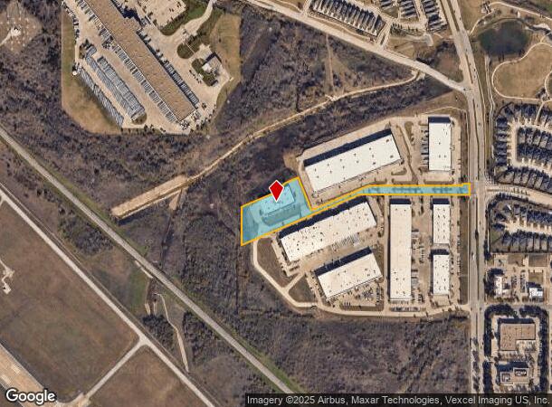
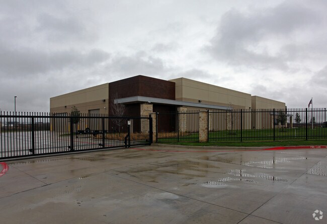
6651 N Belt Line Rd, Irving, TX 75063


NEARBY LISTINGS FOR SALE OR LEASE
Property Detail
6651 N Belt Line Rd
Dallas-Fort Worth-Arlington, TX
Parc 114 3Rd Rev
323866900003A0000
PARC 114 3RD REV BLK LOT 3A ACS 4.548 INT201500242675 DD09082015 CO-DC 3866900003A00 1CI38669000
Warehouse
Dallas
X
Texas
48113C0165K
3a
2024
4.55 AC
2025
E DFW Air/Las Colinas
014150
Dallas/Ft Worth
31,614 SF
DEMOGRAPHICS near 6651 N Belt Line Rd
1 Mile
3 Mile
5 Mile
2024 Total Population
6,141
66,694
199,900
2029 Population
6,055
66,496
199,298
Pop Growth 2024-2029
(1.40%)
(0.30%)
(0.30%)
Average Age
31
33
35
2024 Total Households
2,055
26,561
80,980
HH Growth 2024-2029
(1.80%)
(1.30%)
(0.50%)
Median Household Inc
$127,268
$81,560
$81,897
Avg Household Size
3.00
2.50
2.40
2024 Avg HH Vehicles
2.00
2.00
2.00
Median Home Value
$611,751
$437,603
$364,357
Median Year Built
2000
1992
1992
Nearby Places
Map Layers
Map Styles
 Street
 Aerial
- Restaurants
- Banks
- Shops
- Fitness
- Groceries
PUBLIC TRANSPORTATION
AIRPORT
Dallas-Fort Worth International
DRIVE
WALK
Distance
Dallas-Fort Worth International
10 min
6.9 mi
Dallas Love Field
DRIVE
WALK
Distance
Dallas Love Field
19 min
13.3 mi
Nearby Properties
Address
Land Use
TOTAL SIZE
Lot Size
Zoning
Address
Land Use
TOTAL SIZE
Lot Size
Zoning
3,604,594 SF
490.43 AC
Address
Land Use
TOTAL SIZE
Lot Size
Zoning
2,496,382 SF
256.13 AC
Z392
Address
Land Use
TOTAL SIZE
Lot Size
Zoning
1,520,000 SF
34.76 AC
Z243
Address
Land Use
TOTAL SIZE
Lot Size
Zoning
565,728 SF
21.07 AC
Address
Land Use
TOTAL SIZE
Lot Size
Zoning
379,000 SF
9.81 AC
Z243
Address
Land Use
TOTAL SIZE
Lot Size
Zoning
689,004 SF
25.23 AC
Z243
Address
Land Use
TOTAL SIZE
Lot Size
Zoning
471,524 SF
20.34 AC
Z84
Address
Land Use
TOTAL SIZE
Lot Size
Zoning
1,144,971 SF
19.43 AC
Z84
Address
Land Use
TOTAL SIZE
Lot Size
Zoning
729,870 SF
24.42 AC
Z393
Address
Land Use
TOTAL SIZE
Lot Size
Zoning
550,411 SF
19.39 AC
Z243
Address
Land Use
TOTAL SIZE
Lot Size
Zoning
464,996 SF
18.43 AC
SP2
Address
Land Use
TOTAL SIZE
Lot Size
Zoning
808,352 SF
7.87 AC
Address
Land Use
TOTAL SIZE
Lot Size
Zoning
347,008 SF
9.54 AC
Z57
Address
Land Use
TOTAL SIZE
Lot Size
Zoning
1,219,380 SF
16.01 AC
Z243
Address
Land Use
TOTAL SIZE
Lot Size
Zoning
1,076,400 SF
48.83 AC
Z01
Address
Land Use
TOTAL SIZE
Lot Size
Zoning
457,322 SF
22.98 AC
Z243
Address
Land Use
TOTAL SIZE
Lot Size
Zoning
543,965 SF
8.02 AC
Z323
Address
Land Use
TOTAL SIZE
Lot Size
Zoning
717,650 SF
28.32 AC
Z243
Address
Land Use
TOTAL SIZE
Lot Size
Zoning
204,167 SF
68 AC
Z239
Address
Land Use
TOTAL SIZE
Lot Size
Zoning
414,646 SF
18.37 AC
Z49
Address
Land Use
TOTAL SIZE
Lot Size
Zoning
505,823 SF
29.64 AC
Z113
Address
Land Use
TOTAL SIZE
Lot Size
Zoning
426,365 SF
14.77 AC
Z239
Address
Land Use
TOTAL SIZE
Lot Size
Zoning
634,939 SF
52.29 AC
Z84
Address
Land Use
TOTAL SIZE
Lot Size
Zoning
779,551 SF
6.50 AC
Address
Land Use
TOTAL SIZE
Lot Size
Zoning
581,211 SF
9 AC
Z239
Address
Land Use
TOTAL SIZE
Lot Size
Zoning
476,330 SF
25.63 AC
Z176
Address
Land Use
TOTAL SIZE
Lot Size
Zoning
345,151 SF
11.86 AC
Z243
Address
Land Use
TOTAL SIZE
Lot Size
Zoning
367,000 SF
11.58 AC
Z84
Address
Land Use
TOTAL SIZE
Lot Size
Zoning
402,657 SF
13.16 AC
Z393
Address
Land Use
TOTAL SIZE
Lot Size
Zoning
555,170 SF
3.32 AC
Z239
The World's #1 Commercial Real Estate Marketplace
Connect with us
© 2025 CoStar Group
The information above has been obtained from sources believed reliable. While we do not doubt its accuracy we have not verified it and make no guarantee, warranty or representation about it. It is your responsibility to independently confirm its accuracy and completeness. Any projections, opinions, assumptions, or estimates used are for example only and do not represent the current or future performance of the property. The value of this transaction to you depends on tax and other factors which should be evaluated by your tax, financial, and legal advisors. You and your advisors should conduct a careful, independent investigation of the property to determine to your satisfaction the suitability of the property for your needs.