Property Record
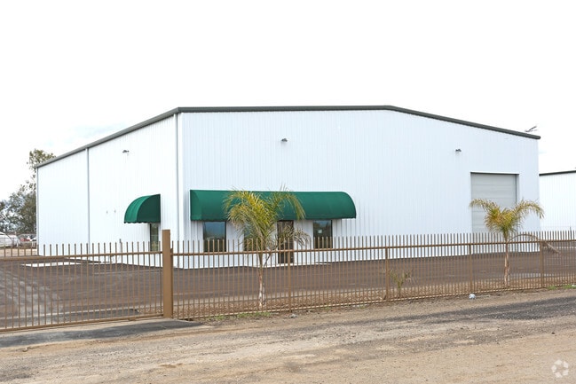
6657 Cherry Ave, Bakersfield, CA 93314


Property Detail
6657 Cherry Ave
104-072-12-00-7
PARCEL MAP 7257 , LOT 1
Commercialnec
Kern
NR
California
B and X Area of moderate flood hazard, usually the area between the limits of the 100-year and 500-year floods.
1
2024
4.79 AC
2025
NW Outlying Kern County
003827
Bakersfield
24,000 SF
Bakersfield-Delano, CA
NEARBY LISTINGS FOR SALE OR LEASE
DEMOGRAPHICS near 6657 Cherry Ave
1 mile
3 mile
5 mile
2025 Total Population
107
891
13,804
2030 Population
111
897
14,052
Pop Growth 2025-2030
+ 3.74%
+ 0.67%
+ 1.80%
Average Age
37
36
36
2025 Total Households
30
209
3,739
HH Growth 2025-2030
+ 3.33%
+ 1.91%
+ 2.19%
Median Household Inc
$162,500
$79,000
$124,527
Avg Household Size
3.20
3.40
3.40
2025 Avg HH Vehicles
2.00
2.00
3.00
Median Home Value
$849,999
$472,058
$586,915
Median Year Built
1994
1974
2004
Nearby Places
Map Layers
Map Styles
 Street
 Aerial
Layers
 Traffic
 Biking
Places
Listings with unknown addresses are not visible on the map
- Restaurants
- Banks
- Shops
- Fitness
- Groceries
PUBLIC TRANSPORTATION
AIRPORT
Meadows Field
Drive
Walk
Distance
Meadows Field
24 min
14.1 mi
Freight Ports
The Port of Hueneme
Drive
Walk
Distance
The Port of Hueneme
165 min
131.4 mi
SALE & LEASE HISTORY
LISTING DATE
SALE/LEASE

Mar 12, 2019
For Lease
Jan 07, 2020
For Lease
Apr 12, 2023
For Lease
Nearby Properties
Address
Land Use
TOTAL SIZE
Lot Size
Zoning
Address
Land Use
TOTAL SIZE
Lot Size
Zoning
19.09 AC
Address
Land Use
TOTAL SIZE
Lot Size
Zoning
4,263 SF
49.09 AC
A
Address
Land Use
TOTAL SIZE
Lot Size
Zoning
84,860 SF
15.35 AC
M-3
Address
Land Use
TOTAL SIZE
Lot Size
Zoning
41.47 AC
M-3
Address
Land Use
TOTAL SIZE
Lot Size
Zoning
263.80 AC
A
Address
Land Use
TOTAL SIZE
Lot Size
Zoning
35,125 SF
20.70 AC
M-2
Address
Land Use
TOTAL SIZE
Lot Size
Zoning
15,000 SF
10.70 AC
M2
Address
Land Use
TOTAL SIZE
Lot Size
Zoning
116.97 AC
A
Address
Land Use
TOTAL SIZE
Lot Size
Zoning
7,200 SF
15.17 AC
M3
Address
Land Use
TOTAL SIZE
Lot Size
Zoning
5,291 SF
3.64 AC
M3
Address
Land Use
TOTAL SIZE
Lot Size
Zoning
589.37 AC
A
Address
Land Use
TOTAL SIZE
Lot Size
Zoning
8,400 SF
45.59 AC
A
Address
Land Use
TOTAL SIZE
Lot Size
Zoning
Address
Land Use
TOTAL SIZE
Lot Size
Zoning
6,250 SF
19.12 AC
NR
Address
Land Use
TOTAL SIZE
Lot Size
Zoning
240.57 AC
A
Address
Land Use
TOTAL SIZE
Lot Size
Zoning
Address
Land Use
TOTAL SIZE
Lot Size
Zoning
6,000 SF
4.60 AC
M-1
Address
Land Use
TOTAL SIZE
Lot Size
Zoning
14,400 SF
4.98 AC
M-2 PD
Address
Land Use
TOTAL SIZE
Lot Size
Zoning
301.78 AC
A
Address
Land Use
TOTAL SIZE
Lot Size
Zoning
31,200 SF
5 AC
M2
Address
Land Use
TOTAL SIZE
Lot Size
Zoning
4.62 AC
M3
Address
Land Use
TOTAL SIZE
Lot Size
Zoning
17,250 SF
4.30 AC
M-2 PD
Address
Land Use
TOTAL SIZE
Lot Size
Zoning
118.18 AC
A
Address
Land Use
TOTAL SIZE
Lot Size
Zoning
2,400 SF
5.02 AC
NR5
Address
Land Use
TOTAL SIZE
Lot Size
Zoning
6,080 SF
39.83 AC
A
Address
Land Use
TOTAL SIZE
Lot Size
Zoning
306.33 AC
A
Address
Land Use
TOTAL SIZE
Lot Size
Zoning
5,701 SF
39.27 AC
A
Address
Land Use
TOTAL SIZE
Lot Size
Zoning
154.54 AC
A
Address
Land Use
TOTAL SIZE
Lot Size
Zoning
20.04 AC
A
The World's #1 Commercial Real Estate Marketplace
Connect with us
© 2026 CoStar Group
The information above has been obtained from sources believed reliable. While we do not doubt its accuracy we have not verified it and make no guarantee, warranty or representation about it. It is your responsibility to independently confirm its accuracy and completeness. Any projections, opinions, assumptions, or estimates used are for example only and do not represent the current or future performance of the property. The value of this transaction to you depends on tax and other factors which should be evaluated by your tax, financial, and legal advisors. You and your advisors should conduct a careful, independent investigation of the property to determine to your satisfaction the suitability of the property for your needs.