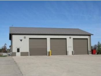
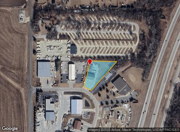
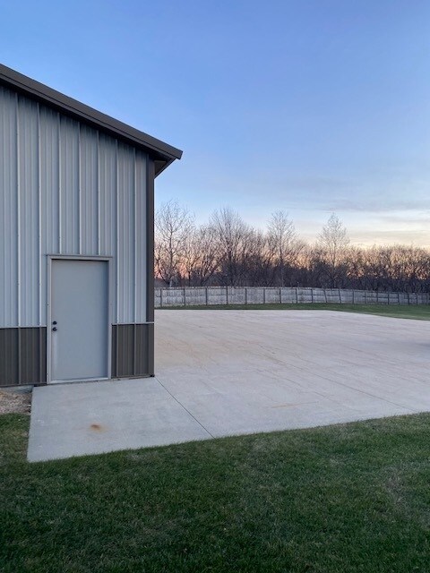
Property Record
6658 10Th Ave Sw, Rochester, MN 55902

NEARBY LISTINGS FOR SALE OR LEASE
Property Detail
6658 10Th Ave Sw
Rochester, MN
Airport Industrial Park
54.02.32.045841
SECT-02 TWP-105 RANGE-014 AIRPORT INDUSTRIAL PARK LOT-003 BLOCK-001 1.15 AC TH PT LOT 3 BLK 1 DES AS FOL COM AT NWCOR SD LOT
Commercialnec
Olmsted
X
Minnesota
27109C0315D
3
2025
1.05 AC
2024
Historic Southwest
001202
Other Market Areas
3,618 SF
DEMOGRAPHICS near 6658 10Th Ave Sw
1 Mile
3 Mile
5 Mile
2024 Total Population
750
6,672
23,695
2029 Population
742
6,807
24,200
Pop Growth 2024-2029
(1.07%)
+ 2.02%
+ 2.13%
Average Age
41
38
39
2024 Total Households
284
2,447
8,951
HH Growth 2024-2029
(1.06%)
+ 1.88%
+ 2.03%
Median Household Inc
$98,097
$119,476
$102,868
Avg Household Size
2.60
2.70
2.60
2024 Avg HH Vehicles
3.00
2.00
2.00
Median Home Value
$361,594
$372,249
$303,706
Median Year Built
1997
2001
1994
Nearby Places
Map Layers
Map Styles
 Street
 Aerial
- Restaurants
- Banks
- Shops
- Fitness
- Groceries
PUBLIC TRANSPORTATION
AIRPORT
Rochester International
DRIVE
WALK
Distance
Rochester International
4 min
1.7 mi
SALE & LEASE HISTORY
LISTING DATE
SALE/LEASE

May 02, 2022
For Lease
Jun 27, 2019
For Lease
Feb 27, 2021
For Lease
Nearby Properties
Address
Land Use
TOTAL SIZE
Lot Size
Zoning
Address
Land Use
TOTAL SIZE
Lot Size
Zoning
6.83 AC
Address
Land Use
TOTAL SIZE
Lot Size
Zoning
287,670 SF
13.59 AC
Address
Land Use
TOTAL SIZE
Lot Size
Zoning
123,608 SF
3.85 AC
Address
Land Use
TOTAL SIZE
Lot Size
Zoning
117,152 SF
3.69 AC
Address
Land Use
TOTAL SIZE
Lot Size
Zoning
5.93 AC
Address
Land Use
TOTAL SIZE
Lot Size
Zoning
81,875 SF
155.34 AC
Address
Land Use
TOTAL SIZE
Lot Size
Zoning
306,910 SF
25.68 AC
Address
Land Use
TOTAL SIZE
Lot Size
Zoning
57.26 AC
Address
Land Use
TOTAL SIZE
Lot Size
Zoning
174,907 SF
13.16 AC
Address
Land Use
TOTAL SIZE
Lot Size
Zoning
159,417 SF
12.17 AC
Address
Land Use
TOTAL SIZE
Lot Size
Zoning
22,106 SF
2.02 AC
Address
Land Use
TOTAL SIZE
Lot Size
Zoning
51,044 SF
3.03 AC
Address
Land Use
TOTAL SIZE
Lot Size
Zoning
39,650 SF
5.68 AC
Address
Land Use
TOTAL SIZE
Lot Size
Zoning
74,986 SF
9.48 AC
Address
Land Use
TOTAL SIZE
Lot Size
Zoning
34,390 SF
6.17 AC
Address
Land Use
TOTAL SIZE
Lot Size
Zoning
103,813 SF
9.30 AC
Address
Land Use
TOTAL SIZE
Lot Size
Zoning
63,714 SF
17.42 AC
Address
Land Use
TOTAL SIZE
Lot Size
Zoning
40,471 SF
1.68 AC
Address
Land Use
TOTAL SIZE
Lot Size
Zoning
50,411 SF
1.42 AC
Address
Land Use
TOTAL SIZE
Lot Size
Zoning
22,320 SF
2.72 AC
Address
Land Use
TOTAL SIZE
Lot Size
Zoning
14,000 SF
5.32 AC
Address
Land Use
TOTAL SIZE
Lot Size
Zoning
30,607 SF
3.68 AC
Address
Land Use
TOTAL SIZE
Lot Size
Zoning
39,300 SF
3.18 AC
Address
Land Use
TOTAL SIZE
Lot Size
Zoning
364 SF
19.75 AC
Address
Land Use
TOTAL SIZE
Lot Size
Zoning
7,896 SF
7.51 AC
Address
Land Use
TOTAL SIZE
Lot Size
Zoning
6,048 SF
4.79 AC
Address
Land Use
TOTAL SIZE
Lot Size
Zoning
22,493 SF
1.43 AC
Address
Land Use
TOTAL SIZE
Lot Size
Zoning
16,272 SF
1.63 AC
Address
Land Use
TOTAL SIZE
Lot Size
Zoning
61,607 SF
3.60 AC
Address
Land Use
TOTAL SIZE
Lot Size
Zoning
28,609 SF
6 AC
The World's #1 Commercial Real Estate Marketplace
Connect with us
© 2025 CoStar Group
The information above has been obtained from sources believed reliable. While we do not doubt its accuracy we have not verified it and make no guarantee, warranty or representation about it. It is your responsibility to independently confirm its accuracy and completeness. Any projections, opinions, assumptions, or estimates used are for example only and do not represent the current or future performance of the property. The value of this transaction to you depends on tax and other factors which should be evaluated by your tax, financial, and legal advisors. You and your advisors should conduct a careful, independent investigation of the property to determine to your satisfaction the suitability of the property for your needs.