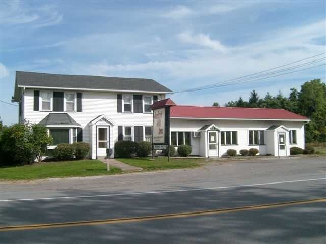
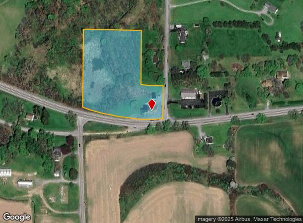
Property Record
6659 W Main Rd, Lima, NY 14485
NEARBY LISTINGS FOR SALE OR LEASE
-
-
View all Lima listings for sale on LoopNet.com
Property Detail
6659 W Main Rd
Rochester, NY
Livingston
243289-036-000-0002-057-141-0000
New York
Bartavern
57.141
2025
4.10 AC
2024
Livingston County
030600
Rochester
3,796 SF
DEMOGRAPHICS near 6659 W Main Rd
1 Mile
3 Mile
5 Mile
2024 Total Population
179
5,327
13,135
2029 Population
175
5,295
12,997
Pop Growth 2024-2029
(2.23%)
(0.60%)
(1.05%)
Average Age
43
42
43
2024 Total Households
69
2,179
5,563
HH Growth 2024-2029
(2.90%)
(0.64%)
(1.10%)
Median Household Inc
$53,333
$66,146
$72,305
Avg Household Size
2.50
2.40
2.30
2024 Avg HH Vehicles
2.00
2.00
2.00
Median Home Value
$177,940
$161,111
$172,740
Median Year Built
1949
1980
1974
Nearby Places
- Restaurants
- Banks
- Shops
- Fitness
- Groceries
PUBLIC TRANSPORTATION
AIRPORT
Frederick Douglass/Greater Rochester International
DRIVE
WALK
Distance
Frederick Douglass/Greater Rochester International
28 min
20.5 mi
Freight Ports
Albany, NY Port
DRIVE
WALK
Distance
Albany, NY Port
277 min
228.4 mi
SALE & LEASE HISTORY
LISTING DATE
SALE/LEASE

Mar 22, 2023
For Sale
Aug 27, 2018
For Sale
Nearby Properties
Address
Land Use
TOTAL SIZE
Lot Size
Zoning
Address
Land Use
TOTAL SIZE
Lot Size
Zoning
1,952 SF
194.63 AC
02 - SINGL
Address
Land Use
TOTAL SIZE
Lot Size
Zoning
0.25 AC
08 - GOVER
Address
Land Use
TOTAL SIZE
Lot Size
Zoning
1,762 SF
34.20 AC
04 - FARM
Address
Land Use
TOTAL SIZE
Lot Size
Zoning
9.86 AC
05 - COMME
Address
Land Use
TOTAL SIZE
Lot Size
Zoning
Address
Land Use
TOTAL SIZE
Lot Size
Zoning
Address
Land Use
TOTAL SIZE
Lot Size
Zoning
29,960 SF
4.60 AC
05 - COMME
Address
Land Use
TOTAL SIZE
Lot Size
Zoning
38,760 SF
5.84 AC
05 - COMME
Address
Land Use
TOTAL SIZE
Lot Size
Zoning
33.70 AC
05 - COMME
Address
Land Use
TOTAL SIZE
Lot Size
Zoning
1,856 SF
21.90 AC
R
Address
Land Use
TOTAL SIZE
Lot Size
Zoning
783 SF
8.01 AC
08 - GOVER
Address
Land Use
TOTAL SIZE
Lot Size
Zoning
7.50 AC
S
Address
Land Use
TOTAL SIZE
Lot Size
Zoning
9,328 SF
28.69 AC
05 - COMME
Address
Land Use
TOTAL SIZE
Lot Size
Zoning
11,408 SF
4.80 AC
03 - MULTI
Address
Land Use
TOTAL SIZE
Lot Size
Zoning
23,360 SF
39.97 AC
04 - FARM
Address
Land Use
TOTAL SIZE
Lot Size
Zoning
Address
Land Use
TOTAL SIZE
Lot Size
Zoning
1,440 SF
5.74 AC
05 - COMME
Address
Land Use
TOTAL SIZE
Lot Size
Zoning
28,720 SF
12.60 AC
06 - INDUS
Address
Land Use
TOTAL SIZE
Lot Size
Zoning
318.20 AC
04 - FARM
Address
Land Use
TOTAL SIZE
Lot Size
Zoning
296.10 AC
04 - FARM
Address
Land Use
TOTAL SIZE
Lot Size
Zoning
5.82 AC
05 - COMME
Address
Land Use
TOTAL SIZE
Lot Size
Zoning
576 SF
15.66 AC
A
Address
Land Use
TOTAL SIZE
Lot Size
Zoning
17,200 SF
3.20 AC
06 - INDUS
Address
Land Use
TOTAL SIZE
Lot Size
Zoning
11,012 SF
2.20 AC
05 - COMME
Address
Land Use
TOTAL SIZE
Lot Size
Zoning
15,773 SF
1.23 AC
05 - COMME
Address
Land Use
TOTAL SIZE
Lot Size
Zoning
19.65 AC
06 - INDUS
Address
Land Use
TOTAL SIZE
Lot Size
Zoning
13,804 SF
3.01 AC
RI
Address
Land Use
TOTAL SIZE
Lot Size
Zoning
Address
Land Use
TOTAL SIZE
Lot Size
Zoning
1,755 SF
27.80 AC
03 - MULTI
Address
Land Use
TOTAL SIZE
Lot Size
Zoning
5,616 SF
2.66 AC
05 - COMME
The World's #1 Commercial Real Estate Marketplace
Connect with us
© 2025 CoStar Group
The information above has been obtained from sources believed reliable. While we do not doubt its accuracy we have not verified it and make no guarantee, warranty or representation about it. It is your responsibility to independently confirm its accuracy and completeness. Any projections, opinions, assumptions, or estimates used are for example only and do not represent the current or future performance of the property. The value of this transaction to you depends on tax and other factors which should be evaluated by your tax, financial, and legal advisors. You and your advisors should conduct a careful, independent investigation of the property to determine to your satisfaction the suitability of the property for your needs.