Property Record
6710 Peach St, Erie, PA 16509

NEARBY LISTINGS FOR SALE OR LEASE
Property Detail
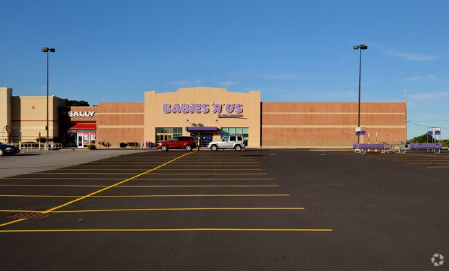
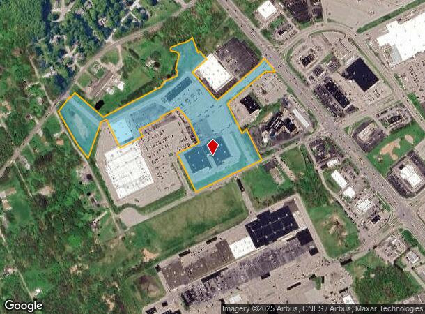
6710 Peach St
40-004-016.0-062.00
Plat Jdn Real Estates Erie Lp
Stripcommercialcenter
6710 6718 PEACH ST 16.835 AC REF MB L2001-191 & L2003-20
X
Erie
42049C0212D
Pennsylvania
2025
18.84 AC
2025
Outlying Erie County
011202
Erie
18,460 SF
Erie, PA
DEMOGRAPHICS near 6710 Peach St
1 Mile
3 Mile
5 Mile
2024 Total Population
2,873
41,421
122,308
2029 Population
2,885
40,904
120,818
Pop Growth 2024-2029
+ 0.42%
(1.25%)
(1.22%)
Average Age
42
43
41
2024 Total Households
1,460
18,102
51,949
HH Growth 2024-2029
+ 0.48%
(1.34%)
(1.30%)
Median Household Inc
$57,699
$66,858
$56,098
Avg Household Size
1.80
2.20
2.20
2024 Avg HH Vehicles
1.00
2.00
2.00
Median Home Value
$199,555
$172,645
$150,964
Median Year Built
1977
1972
1960
Nearby Places
Map Layers
Map Styles
 Street
 Aerial
- Restaurants
- Banks
- Shops
- Fitness
- Groceries
PUBLIC TRANSPORTATION
COMMUTER RAIL
DRIVE
WALK
Distance
12 min
5.0 mi
AIRPORT
Erie International/Tom Ridge Field
DRIVE
WALK
Distance
Erie International/Tom Ridge Field
15 min
7.5 mi
Nearby Properties
Address
Land Use
TOTAL SIZE
Lot Size
Zoning
Address
Land Use
TOTAL SIZE
Lot Size
Zoning
35,529 SF
84.04 AC
BB
Address
Land Use
TOTAL SIZE
Lot Size
Zoning
1,121,950 SF
80.70 AC
I1
Address
Land Use
TOTAL SIZE
Lot Size
Zoning
8,337 SF
13.31 AC
B1
Address
Land Use
TOTAL SIZE
Lot Size
Zoning
14,688 SF
39.53 AC
AR
Address
Land Use
TOTAL SIZE
Lot Size
Zoning
108,080 SF
4.83 AC
AR
Address
Land Use
TOTAL SIZE
Lot Size
Zoning
10,960 SF
29.82 AC
DR
Address
Land Use
TOTAL SIZE
Lot Size
Zoning
227,718 SF
47.43 AC
DB
Address
Land Use
TOTAL SIZE
Lot Size
Zoning
171,306 SF
6.30 AC
AR
Address
Land Use
TOTAL SIZE
Lot Size
Zoning
127,756 SF
7.21 AC
RLB
Address
Land Use
TOTAL SIZE
Lot Size
Zoning
2,754 SF
26.83 AC
DB
Address
Land Use
TOTAL SIZE
Lot Size
Zoning
198,102 SF
27.63 AC
B1
Address
Land Use
TOTAL SIZE
Lot Size
Zoning
80,390 SF
69.53 AC
B1
Address
Land Use
TOTAL SIZE
Lot Size
Zoning
3,340 SF
37.04 AC
AR
Address
Land Use
TOTAL SIZE
Lot Size
Zoning
38 AC
AR
Address
Land Use
TOTAL SIZE
Lot Size
Zoning
100,586 SF
4.89 AC
AB
Address
Land Use
TOTAL SIZE
Lot Size
Zoning
73,078 SF
13.80 AC
B1
Address
Land Use
TOTAL SIZE
Lot Size
Zoning
4,600 SF
50.38 AC
R3
Address
Land Use
TOTAL SIZE
Lot Size
Zoning
100,443 SF
6 AC
B1
Address
Land Use
TOTAL SIZE
Lot Size
Zoning
146.02 AC
R2
Address
Land Use
TOTAL SIZE
Lot Size
Zoning
48,645 SF
3.30 AC
Address
Land Use
TOTAL SIZE
Lot Size
Zoning
36,406 SF
20 AC
Address
Land Use
TOTAL SIZE
Lot Size
Zoning
125,399 SF
10.93 AC
BB
Address
Land Use
TOTAL SIZE
Lot Size
Zoning
89,004 SF
2.80 AC
Address
Land Use
TOTAL SIZE
Lot Size
Zoning
4,476 SF
70.28 AC
B1
Address
Land Use
TOTAL SIZE
Lot Size
Zoning
37,032 SF
23.84 AC
Address
Land Use
TOTAL SIZE
Lot Size
Zoning
41,352 SF
12.21 AC
DR
Address
Land Use
TOTAL SIZE
Lot Size
Zoning
109,814 SF
9.66 AC
BB
Address
Land Use
TOTAL SIZE
Lot Size
Zoning
69,560 SF
3.36 AC
Address
Land Use
TOTAL SIZE
Lot Size
Zoning
10,096 SF
15.55 AC
DR
The World's #1 Commercial Real Estate Marketplace
Connect with us
© 2025 CoStar Group
The information above has been obtained from sources believed reliable. While we do not doubt its accuracy we have not verified it and make no guarantee, warranty or representation about it. It is your responsibility to independently confirm its accuracy and completeness. Any projections, opinions, assumptions, or estimates used are for example only and do not represent the current or future performance of the property. The value of this transaction to you depends on tax and other factors which should be evaluated by your tax, financial, and legal advisors. You and your advisors should conduct a careful, independent investigation of the property to determine to your satisfaction the suitability of the property for your needs.