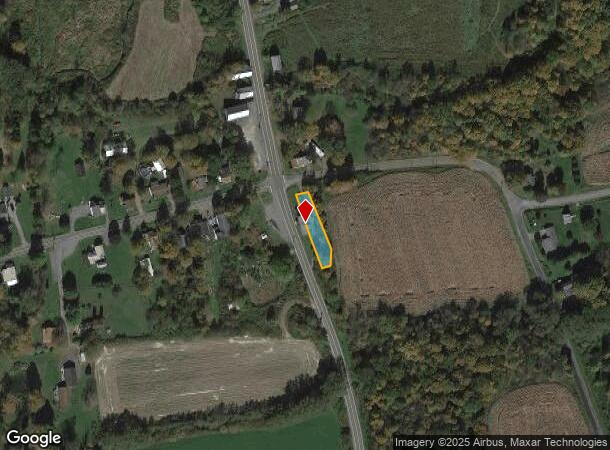
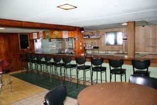
Property Record
6660 State Route 41, Homer, NY 13077

NEARBY LISTINGS FOR SALE OR LEASE
-
-
View all Homer listings for sale on LoopNet.com
Property Detail
6660 State Route 41
113800-025-000-0001-060-000-0000
Cortland
Bartavern
New York
X
60.000
36023C0126D
0.21 AC
2024
Cortland County
2024
Syracuse
970202
Cortland, NY
2,992 SF
DEMOGRAPHICS near 6660 State Route 41
1 Mile
3 Mile
5 Mile
2024 Total Population
301
1,138
3,514
2029 Population
301
1,136
3,475
Pop Growth 2024-2029
0.00%
(0.18%)
(1.11%)
Average Age
42
42
43
2024 Total Households
114
433
1,374
HH Growth 2024-2029
0.00%
(0.23%)
(1.31%)
Median Household Inc
$83,750
$82,394
$85,615
Avg Household Size
2.60
2.60
2.60
2024 Avg HH Vehicles
2.00
2.00
2.00
Median Home Value
$151,999
$156,077
$181,556
Median Year Built
1975
1975
1973
Nearby Places
- Restaurants
- Banks
- Shops
- Fitness
- Groceries
PUBLIC TRANSPORTATION
AIRPORT
Ithaca Tompkins International
DRIVE
WALK
Distance
Ithaca Tompkins International
45 min
28.0 mi
Syracuse Hancock International
DRIVE
WALK
Distance
Syracuse Hancock International
59 min
43.3 mi
Freight Ports
Albany, NY Port
DRIVE
WALK
Distance
Albany, NY Port
212 min
165.9 mi
Nearby Properties
Address
Land Use
TOTAL SIZE
Lot Size
Zoning
Address
Land Use
TOTAL SIZE
Lot Size
Zoning
529.18 AC
Address
Land Use
TOTAL SIZE
Lot Size
Zoning
1,114 SF
122.55 AC
04 - FARM
Address
Land Use
TOTAL SIZE
Lot Size
Zoning
98.09 AC
04 - FARM
Address
Land Use
TOTAL SIZE
Lot Size
Zoning
8,384 SF
2.35 AC
Address
Land Use
TOTAL SIZE
Lot Size
Zoning
3,634 SF
5.80 AC
Address
Land Use
TOTAL SIZE
Lot Size
Zoning
179.80 AC
04 - FARM
Address
Land Use
TOTAL SIZE
Lot Size
Zoning
1,575 SF
24.10 AC
01 - NOT Z
Address
Land Use
TOTAL SIZE
Lot Size
Zoning
164.20 AC
Address
Land Use
TOTAL SIZE
Lot Size
Zoning
209.40 AC
01 - NOT Z
Address
Land Use
TOTAL SIZE
Lot Size
Zoning
5,940 SF
7.84 AC
04
Address
Land Use
TOTAL SIZE
Lot Size
Zoning
864 SF
9.61 AC
Address
Land Use
TOTAL SIZE
Lot Size
Zoning
144.90 AC
04 - FARM
Address
Land Use
TOTAL SIZE
Lot Size
Zoning
119.40 AC
01 - NOT Z
Address
Land Use
TOTAL SIZE
Lot Size
Zoning
1,986 SF
3.39 AC
04 - FARM
Address
Land Use
TOTAL SIZE
Lot Size
Zoning
1,424 SF
2.80 AC
Address
Land Use
TOTAL SIZE
Lot Size
Zoning
300 SF
6.36 AC
Address
Land Use
TOTAL SIZE
Lot Size
Zoning
1,400 SF
12.20 AC
01 - NOT Z
Address
Land Use
TOTAL SIZE
Lot Size
Zoning
3,192 SF
2.45 AC
04 - FARM
Address
Land Use
TOTAL SIZE
Lot Size
Zoning
0.11 AC
04 - FARM
Address
Land Use
TOTAL SIZE
Lot Size
Zoning
1,344 SF
10 AC
01 - NOT Z
Address
Land Use
TOTAL SIZE
Lot Size
Zoning
107.85 AC
01 - NOT Z
Address
Land Use
TOTAL SIZE
Lot Size
Zoning
153.30 AC
04 - FARM
Address
Land Use
TOTAL SIZE
Lot Size
Zoning
112.40 AC
01 - NOT Z
Address
Land Use
TOTAL SIZE
Lot Size
Zoning
160.80 AC
Address
Land Use
TOTAL SIZE
Lot Size
Zoning
112 AC
04 - FARM
Address
Land Use
TOTAL SIZE
Lot Size
Zoning
194.10 AC
Address
Land Use
TOTAL SIZE
Lot Size
Zoning
1,748 SF
0.36 AC
Address
Land Use
TOTAL SIZE
Lot Size
Zoning
129.81 AC
04 - FARM
Address
Land Use
TOTAL SIZE
Lot Size
Zoning
101.60 AC
01 - NOT Z
Address
Land Use
TOTAL SIZE
Lot Size
Zoning
84 AC
The World's #1 Commercial Real Estate Marketplace
Connect with us
© 2025 CoStar Group
The information above has been obtained from sources believed reliable. While we do not doubt its accuracy we have not verified it and make no guarantee, warranty or representation about it. It is your responsibility to independently confirm its accuracy and completeness. Any projections, opinions, assumptions, or estimates used are for example only and do not represent the current or future performance of the property. The value of this transaction to you depends on tax and other factors which should be evaluated by your tax, financial, and legal advisors. You and your advisors should conduct a careful, independent investigation of the property to determine to your satisfaction the suitability of the property for your needs.