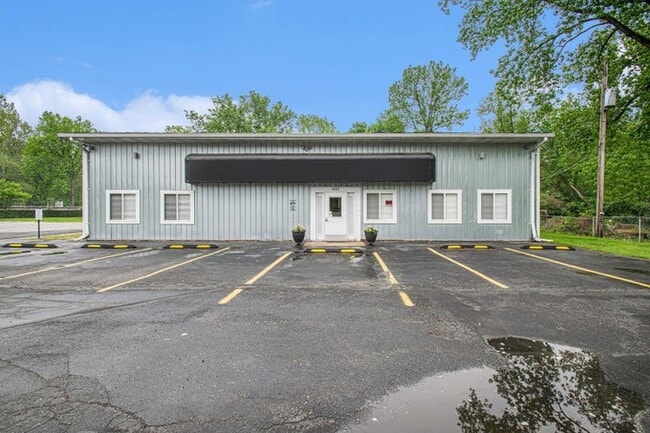
Property Record
6662 W Johnson Rd, La Porte, IN 46350
Current Lease Availabilities
NEARBY LISTINGS FOR SALE OR LEASE
Property Detail
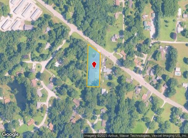
6662 W Johnson Rd
46-05-13-179-002.000-046
11-05-13-179-002 MID PT E 1/2 NW 1/4 S OF RD. S13 T37 R4. 1 A.
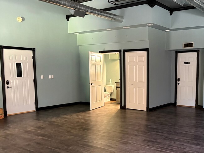
Warehouse
La Porte
X
Indiana
18091C0140D
1 AC
2023
South Bend/Elkhart
2024
Other Market Areas
041500
Michigan City-La Porte, IN
7,088 SF
DEMOGRAPHICS near 6662 W Johnson Rd
1 Mile
3 Mile
5 Mile
2024 Total Population
1,639
11,268
39,700
2029 Population
1,585
10,987
39,141
Pop Growth 2024-2029
(3.29%)
(2.49%)
(1.41%)
Average Age
45
43
41
2024 Total Households
640
4,735
16,378
HH Growth 2024-2029
(3.59%)
(2.75%)
(1.67%)
Median Household Inc
$93,877
$66,996
$59,740
Avg Household Size
2.50
2.30
2.30
2024 Avg HH Vehicles
3.00
2.00
2.00
Median Home Value
$248,214
$200,163
$154,209
Median Year Built
1977
1976
1968
Nearby Places
- Restaurants
- Banks
- Shops
- Fitness
- Groceries
PUBLIC TRANSPORTATION
COMMUTER RAIL
Carroll Avenue (Michigan City) Station (South Shore Line - Northern Indiana Commuter Transportation District (South Shore Line))
DRIVE
WALK
Distance
Carroll Avenue (Michigan City) Station (South Shore Line - Northern Indiana Commuter Transportation District (South Shore Line))
11 min
4.6 mi
DRIVE
WALK
Distance
13 min
6.0 mi
AIRPORT
South Bend International
DRIVE
WALK
Distance
South Bend International
55 min
35.9 mi
Nearby Properties
Address
Land Use
TOTAL SIZE
Lot Size
Zoning
Address
Land Use
TOTAL SIZE
Lot Size
Zoning
168,624 SF
9.47 AC
Address
Land Use
TOTAL SIZE
Lot Size
Zoning
154,171 SF
9.92 AC
Address
Land Use
TOTAL SIZE
Lot Size
Zoning
201,125 SF
7.95 AC
Address
Land Use
TOTAL SIZE
Lot Size
Zoning
122,915 SF
23.23 AC
Address
Land Use
TOTAL SIZE
Lot Size
Zoning
139,650 SF
9.45 AC
Address
Land Use
TOTAL SIZE
Lot Size
Zoning
207,823 SF
18.28 AC
Address
Land Use
TOTAL SIZE
Lot Size
Zoning
42,414 SF
4.81 AC
Address
Land Use
TOTAL SIZE
Lot Size
Zoning
103,465 SF
7 AC
Address
Land Use
TOTAL SIZE
Lot Size
Zoning
54,160 SF
3.85 AC
Address
Land Use
TOTAL SIZE
Lot Size
Zoning
199,835 SF
23.86 AC
Address
Land Use
TOTAL SIZE
Lot Size
Zoning
22,106 SF
3.59 AC
Address
Land Use
TOTAL SIZE
Lot Size
Zoning
18,912 SF
13 AC
Address
Land Use
TOTAL SIZE
Lot Size
Zoning
29,606 SF
2.88 AC
Address
Land Use
TOTAL SIZE
Lot Size
Zoning
20,784 SF
2.01 AC
Address
Land Use
TOTAL SIZE
Lot Size
Zoning
63,320 SF
5.37 AC
Address
Land Use
TOTAL SIZE
Lot Size
Zoning
20,414 SF
3.32 AC
Address
Land Use
TOTAL SIZE
Lot Size
Zoning
41,981 SF
4.04 AC
Address
Land Use
TOTAL SIZE
Lot Size
Zoning
49,536 SF
6.39 AC
Address
Land Use
TOTAL SIZE
Lot Size
Zoning
16,980 SF
17.24 AC
Address
Land Use
TOTAL SIZE
Lot Size
Zoning
58,005 SF
19.25 AC
Address
Land Use
TOTAL SIZE
Lot Size
Zoning
59,645 SF
10.75 AC
Address
Land Use
TOTAL SIZE
Lot Size
Zoning
576 SF
40.14 AC
Address
Land Use
TOTAL SIZE
Lot Size
Zoning
4,608 SF
2.03 AC
Address
Land Use
TOTAL SIZE
Lot Size
Zoning
33,071 SF
2.96 AC
Address
Land Use
TOTAL SIZE
Lot Size
Zoning
10,119 SF
23.71 AC
Address
Land Use
TOTAL SIZE
Lot Size
Zoning
7,082 SF
76.35 AC
Address
Land Use
TOTAL SIZE
Lot Size
Zoning
24,456 SF
2.76 AC
Address
Land Use
TOTAL SIZE
Lot Size
Zoning
21,000 SF
4.63 AC
Address
Land Use
TOTAL SIZE
Lot Size
Zoning
23,800 SF
8.40 AC
Address
Land Use
TOTAL SIZE
Lot Size
Zoning
5,784 SF
1 AC
The World's #1 Commercial Real Estate Marketplace
Connect with us
© 2025 CoStar Group
The information above has been obtained from sources believed reliable. While we do not doubt its accuracy we have not verified it and make no guarantee, warranty or representation about it. It is your responsibility to independently confirm its accuracy and completeness. Any projections, opinions, assumptions, or estimates used are for example only and do not represent the current or future performance of the property. The value of this transaction to you depends on tax and other factors which should be evaluated by your tax, financial, and legal advisors. You and your advisors should conduct a careful, independent investigation of the property to determine to your satisfaction the suitability of the property for your needs.