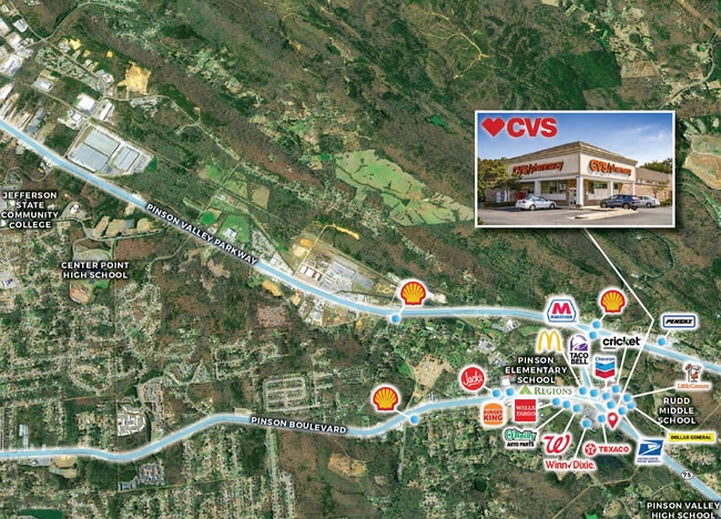
Property Record
6665 Highway 75, Pinson, AL 35126

NEARBY LISTINGS FOR SALE OR LEASE
-
-
View all Pinson listings for sale on LoopNet.com
Property Detail
6665 Highway 75
09-00-30-4-000-011.003
COM NE COR OF SW 1/4 OF SE 1/4 SEC 30 TP 15 R 1W TH N 21 FT TO POB TH SW 115 FT TH NW 192.9 FT TH SW 75.6 FT TH SE 136.9 FT TH SW 170.9 FT TH SELY 192.2 FT TH NE 195.4 FT TH N 128.3 FT TO POB
Storebuilding
Jefferson
X
Alabama
01073C0233J
7
2023
1.46 AC
2024
Fultondale
011205
Birmingham
10,107 SF
Birmingham-Hoover, AL
DEMOGRAPHICS near 6665 Highway 75
1 Mile
3 Mile
5 Mile
2024 Total Population
1,346
18,720
57,051
2029 Population
1,311
18,260
55,807
Pop Growth 2024-2029
(2.60%)
(2.46%)
(2.18%)
Average Age
41
37
37
2024 Total Households
516
6,867
21,298
HH Growth 2024-2029
(2.71%)
(2.49%)
(2.23%)
Median Household Inc
$70,617
$56,253
$53,166
Avg Household Size
2.60
2.70
2.60
2024 Avg HH Vehicles
2.00
2.00
2.00
Median Home Value
$173,588
$157,709
$155,360
Median Year Built
1980
1983
1980
Nearby Places
Map Layers
Map Styles
 Street
 Aerial
- Restaurants
- Banks
- Shops
- Fitness
- Groceries
PUBLIC TRANSPORTATION
AIRPORT
Birmingham-Shuttlesworth International
DRIVE
WALK
Distance
Birmingham-Shuttlesworth International
23 min
13.4 mi
Freight Ports
Port of Mobile
DRIVE
WALK
Distance
Port of Mobile
304 min
272.3 mi
SALE & LEASE HISTORY
LISTING DATE
SALE/LEASE

Nov 05, 2021
For Sale
Nearby Properties
Address
Land Use
TOTAL SIZE
Lot Size
Zoning
Address
Land Use
TOTAL SIZE
Lot Size
Zoning
192,596 SF
13.79 AC
CR5
Address
Land Use
TOTAL SIZE
Lot Size
Zoning
117,342 SF
36 AC
I
Address
Land Use
TOTAL SIZE
Lot Size
Zoning
81,817 SF
9.30 AC
C1
Address
Land Use
TOTAL SIZE
Lot Size
Zoning
56,504 SF
2 AC
C1-C
Address
Land Use
TOTAL SIZE
Lot Size
Zoning
63,736 SF
11 AC
I
Address
Land Use
TOTAL SIZE
Lot Size
Zoning
61,472 SF
18.84 AC
INT-
Address
Land Use
TOTAL SIZE
Lot Size
Zoning
45,806 SF
9 AC
INST
Address
Land Use
TOTAL SIZE
Lot Size
Zoning
58,816 SF
2.98 AC
C1
Address
Land Use
TOTAL SIZE
Lot Size
Zoning
40,535 SF
4 AC
INST
Address
Land Use
TOTAL SIZE
Lot Size
Zoning
34,755 SF
1.28 AC
INST
Address
Land Use
TOTAL SIZE
Lot Size
Zoning
148,564 SF
11 AC
I2
Address
Land Use
TOTAL SIZE
Lot Size
Zoning
78,024 SF
10.90 AC
I-1
Address
Land Use
TOTAL SIZE
Lot Size
Zoning
20,625 SF
5.30 AC
A1IN
Address
Land Use
TOTAL SIZE
Lot Size
Zoning
12,871 SF
2.52 AC
C1
Address
Land Use
TOTAL SIZE
Lot Size
Zoning
12,683 SF
0.54 AC
C1
Address
Land Use
TOTAL SIZE
Lot Size
Zoning
19,512 SF
7.10 AC
I1
Address
Land Use
TOTAL SIZE
Lot Size
Zoning
5,458 SF
2.42 AC
C1
Address
Land Use
TOTAL SIZE
Lot Size
Zoning
11,100 SF
1.40 AC
C1
Address
Land Use
TOTAL SIZE
Lot Size
Zoning
19,284 SF
3.30 AC
CO&I
Address
Land Use
TOTAL SIZE
Lot Size
Zoning
8,230 SF
3.80 AC
I1
Address
Land Use
TOTAL SIZE
Lot Size
Zoning
10,504 SF
1.61 AC
I-1
Address
Land Use
TOTAL SIZE
Lot Size
Zoning
13,372 SF
1.40 AC
I1-C
Address
Land Use
TOTAL SIZE
Lot Size
Zoning
86,320 SF
7.07 AC
C1-I
Address
Land Use
TOTAL SIZE
Lot Size
Zoning
Address
Land Use
TOTAL SIZE
Lot Size
Zoning
3,334 SF
1.11 AC
C1
Address
Land Use
TOTAL SIZE
Lot Size
Zoning
2,790 SF
1.02 AC
C1
Address
Land Use
TOTAL SIZE
Lot Size
Zoning
28,078 SF
7.90 AC
R2
Address
Land Use
TOTAL SIZE
Lot Size
Zoning
3,999 SF
0.90 AC
C3-C
Address
Land Use
TOTAL SIZE
Lot Size
Zoning
5,416 SF
10 AC
R1
The World's #1 Commercial Real Estate Marketplace
Connect with us
© 2025 CoStar Group
The information above has been obtained from sources believed reliable. While we do not doubt its accuracy we have not verified it and make no guarantee, warranty or representation about it. It is your responsibility to independently confirm its accuracy and completeness. Any projections, opinions, assumptions, or estimates used are for example only and do not represent the current or future performance of the property. The value of this transaction to you depends on tax and other factors which should be evaluated by your tax, financial, and legal advisors. You and your advisors should conduct a careful, independent investigation of the property to determine to your satisfaction the suitability of the property for your needs.