Property Record
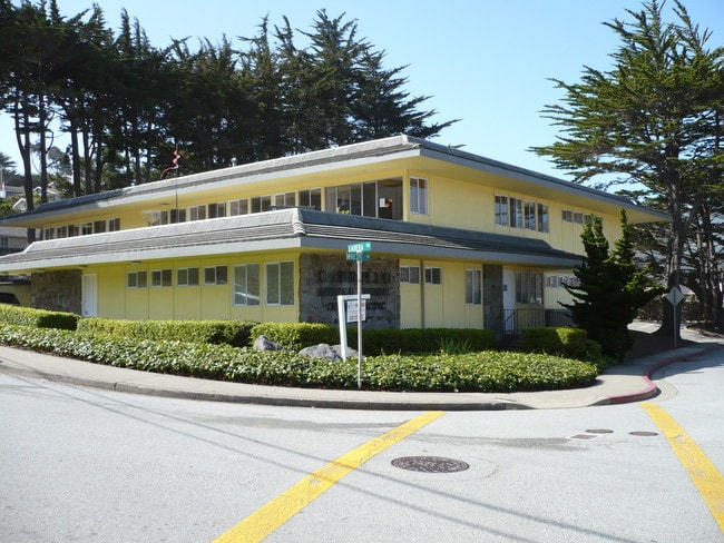
667 Crespi Dr, Pacifica, CA 94044

This Property Is For Sale
NEARBY LISTINGS FOR SALE OR LEASE
Property Detail
667 Crespi Dr
San Francisco-San Mateo-Redwood City, CA
Linda Mar No 8
022-242-050
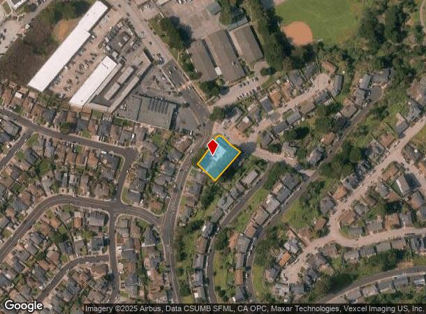
ON COR OF LADERA WAY & CRESPI DR ADJ TO LOTS 49 51 52 BLOCK 31 OF LINDA MAR NO 8 ACREAGE CITY OF PACIFICA
Officebuilding
San Mateo
X
California
06081C0126F
49
2024
8 AC
2025
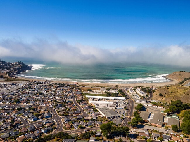
Peninsula Coastline
603100
San Francisco
DEMOGRAPHICS near 667 Crespi Dr
1 mile
3 mile
5 mile
2024 Total Population
8,556
22,659
111,571
2029 Population
8,098
21,519
105,687
Pop Growth 2024-2029
(5.35%)
(5.03%)
(5.27%)
Average Age
44
45
44
2024 Total Households
3,137
8,520
39,217
HH Growth 2024-2029
(5.61%)
(5.26%)
(5.53%)
Median Household Inc
$134,991
$136,938
$132,513
Avg Household Size
2.70
2.60
2.70
2024 Avg HH Vehicles
2.00
2.00
2.00
Median Home Value
$1,091,833
$1,094,203
$1,085,339
Median Year Built
1959
1964
1966
Nearby Places
Map Layers
Map Styles
 Street
 Aerial
Transit
 Traffic
 Biking
Places
Listings with unknown addresses are not visible on the map
- Restaurants
- Banks
- Shops
- Fitness
- Groceries
PUBLIC TRANSPORTATION
COMMUTER RAIL
Drive
Walk
Distance
15 min
8.4 mi
South San Francisco (Caltrain - Caltrain (Caltrain))
Drive
Walk
Distance
South San Francisco (Caltrain - Caltrain (Caltrain))
17 min
9.0 mi
AIRPORT
San Francisco International
Drive
Walk
Distance
San Francisco International
21 min
11.0 mi
Metro Oakland International
Drive
Walk
Distance
Metro Oakland International
51 min
35.8 mi
Norman Y Mineta San Jose International
Drive
Walk
Distance
Norman Y Mineta San Jose International
57 min
42.7 mi
Freight Ports
Port of San Francisco
Drive
Walk
Distance
Port of San Francisco
27 min
19.2 mi
Nearby Properties
Address
Land Use
TOTAL SIZE
Lot Size
Zoning
Address
Land Use
TOTAL SIZE
Lot Size
Zoning
58,775 SF
3.04 AC
R30000
Address
Land Use
TOTAL SIZE
Lot Size
Zoning
144,294 SF
12.12 AC
CL00C1
Address
Land Use
TOTAL SIZE
Lot Size
Zoning
73,485 SF
3.94 AC
R30000
Address
Land Use
TOTAL SIZE
Lot Size
Zoning
83,760 SF
1.49 AC
R30000
Address
Land Use
TOTAL SIZE
Lot Size
Zoning
0.75 AC
Address
Land Use
TOTAL SIZE
Lot Size
Zoning
74,279 SF
2.28 AC
R30000
Address
Land Use
TOTAL SIZE
Lot Size
Zoning
74,815 SF
1.70 AC
Address
Land Use
TOTAL SIZE
Lot Size
Zoning
23,940 SF
0.55 AC
CL00C1
Address
Land Use
TOTAL SIZE
Lot Size
Zoning
51,861 SF
1.53 AC
R30000
Address
Land Use
TOTAL SIZE
Lot Size
Zoning
20,408 SF
1.57 AC
CL00C2
Address
Land Use
TOTAL SIZE
Lot Size
Zoning
9.10 AC
PF0000
Address
Land Use
TOTAL SIZE
Lot Size
Zoning
31,630 SF
0.99 AC
Address
Land Use
TOTAL SIZE
Lot Size
Zoning
31,630 SF
0.75 AC
Address
Land Use
TOTAL SIZE
Lot Size
Zoning
6.70 AC
Address
Land Use
TOTAL SIZE
Lot Size
Zoning
1.44 AC
Address
Land Use
TOTAL SIZE
Lot Size
Zoning
34,207 SF
1.72 AC
Address
Land Use
TOTAL SIZE
Lot Size
Zoning
5,897 SF
2 AC
Address
Land Use
TOTAL SIZE
Lot Size
Zoning
2.63 AC
CL00C2
Address
Land Use
TOTAL SIZE
Lot Size
Zoning
8,239 SF
0.28 AC
Address
Land Use
TOTAL SIZE
Lot Size
Zoning
7.56 AC
00099X
Address
Land Use
TOTAL SIZE
Lot Size
Zoning
9,944 SF
0.34 AC
Address
Land Use
TOTAL SIZE
Lot Size
Zoning
8,312 SF
0.22 AC
Address
Land Use
TOTAL SIZE
Lot Size
Zoning
1,257 SF
171.30 AC
AB0005
Address
Land Use
TOTAL SIZE
Lot Size
Zoning
1.23 AC
Address
Land Use
TOTAL SIZE
Lot Size
Zoning
31,732 SF
0.68 AC
C10000
Address
Land Use
TOTAL SIZE
Lot Size
Zoning
9,987 SF
0.17 AC
Address
Land Use
TOTAL SIZE
Lot Size
Zoning
7,360 SF
0.21 AC
Address
Land Use
TOTAL SIZE
Lot Size
Zoning
8,524 SF
0.21 AC
The World's #1 Commercial Real Estate Marketplace
Connect with us
© 2026 CoStar Group
The information above has been obtained from sources believed reliable. While we do not doubt its accuracy we have not verified it and make no guarantee, warranty or representation about it. It is your responsibility to independently confirm its accuracy and completeness. Any projections, opinions, assumptions, or estimates used are for example only and do not represent the current or future performance of the property. The value of this transaction to you depends on tax and other factors which should be evaluated by your tax, financial, and legal advisors. You and your advisors should conduct a careful, independent investigation of the property to determine to your satisfaction the suitability of the property for your needs.