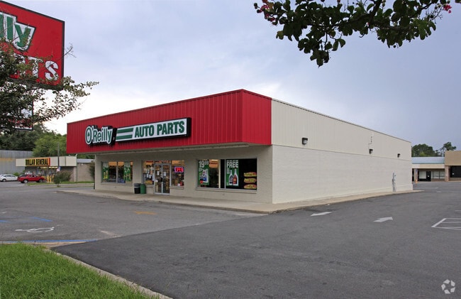
Property Record
667 E Base St, Madison, FL 32340

Property Detail
667 E Base St
22-1N-09-4080-001-000
FROM THE NE COR OF THE S2 OF NE4 OF SE4 RUN W 795' TO THE NE COR THEN S 548' TO THE N ROW LINE OF US HWY 90 40' FROM CTR THEREOF, W 344' TO SE COR & POB CONT W 138' NW 25' N 126 E 148' S 154' TO POB OR 509 PG 191 OR 823 PG 283 OR 1353 PG 98 OR 1353 P
Storemultistory
Madison
A Areas with a 1% annual chance of flooding and a 26% chance of flooding over the life of a 30-year mortgage.
Florida
2025
0.51 AC
2025
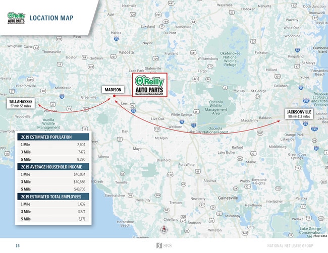
Florida Panhandle Area
110301
Other Market Areas
6,978 SF
NEARBY LISTINGS FOR SALE OR LEASE
DEMOGRAPHICS near 667 E Base St
1 mile
3 mile
5 mile
2025 Total Population
2,644
7,169
8,557
2030 Population
2,714
7,326
8,736
Pop Growth 2025-2030
+ 2.65%
+ 2.19%
+ 2.09%
Average Age
43
43
43
2025 Total Households
1,098
2,574
3,104
HH Growth 2025-2030
+ 2.55%
+ 2.87%
+ 2.71%
Median Household Inc
$43,928
$39,970
$44,413
Avg Household Size
2.30
2.30
2.30
2025 Avg HH Vehicles
2.00
2.00
2.00
Median Home Value
$118,351
$116,180
$122,649
Median Year Built
1971
1977
1979
Nearby Places
Map Layers
Map Styles
 Street
 Aerial
Layers
 Traffic
 Biking
Places
Listings with unknown addresses are not visible on the map
- Restaurants
- Banks
- Shops
- Fitness
- Groceries
PUBLIC TRANSPORTATION
AIRPORT
Valdosta Regional
Drive
Walk
Distance
Valdosta Regional
37 min
25.4 mi
SALE & LEASE HISTORY
LISTING DATE
SALE/LEASE

Jan 08, 2020
For Sale
Nearby Properties
Address
Land Use
TOTAL SIZE
Lot Size
Zoning
Address
Land Use
TOTAL SIZE
Lot Size
Zoning
212,291 SF
59.16 AC
Address
Land Use
TOTAL SIZE
Lot Size
Zoning
228,223 SF
94.53 AC
INC
Address
Land Use
TOTAL SIZE
Lot Size
Zoning
78,953 SF
4.05 AC
INC
Address
Land Use
TOTAL SIZE
Lot Size
Zoning
113,576 SF
8.92 AC
INC
Address
Land Use
TOTAL SIZE
Lot Size
Zoning
46,885 SF
4.84 AC
Address
Land Use
TOTAL SIZE
Lot Size
Zoning
40,872 SF
9.60 AC
Address
Land Use
TOTAL SIZE
Lot Size
Zoning
106,153 SF
10.22 AC
R2
Address
Land Use
TOTAL SIZE
Lot Size
Zoning
32,536 SF
2.03 AC
Address
Land Use
TOTAL SIZE
Lot Size
Zoning
27,283 SF
24.74 AC
Address
Land Use
TOTAL SIZE
Lot Size
Zoning
23,066 SF
5 AC
Address
Land Use
TOTAL SIZE
Lot Size
Zoning
57,806 SF
6.83 AC
INC
Address
Land Use
TOTAL SIZE
Lot Size
Zoning
13,486 SF
1.01 AC
INC
Address
Land Use
TOTAL SIZE
Lot Size
Zoning
11,432 SF
3.56 AC
Address
Land Use
TOTAL SIZE
Lot Size
Zoning
228.95 AC
Address
Land Use
TOTAL SIZE
Lot Size
Zoning
50,894 SF
5.74 AC
C5
Address
Land Use
TOTAL SIZE
Lot Size
Zoning
73,847 SF
4.60 AC
Address
Land Use
TOTAL SIZE
Lot Size
Zoning
64,621 SF
7.05 AC
Address
Land Use
TOTAL SIZE
Lot Size
Zoning
29,088 SF
0.68 AC
Address
Land Use
TOTAL SIZE
Lot Size
Zoning
10,918 SF
0.46 AC
Address
Land Use
TOTAL SIZE
Lot Size
Zoning
15,319 SF
6.50 AC
Address
Land Use
TOTAL SIZE
Lot Size
Zoning
22,384 SF
0.92 AC
Address
Land Use
TOTAL SIZE
Lot Size
Zoning
30,868 SF
7.77 AC
INC
Address
Land Use
TOTAL SIZE
Lot Size
Zoning
27,467 SF
4.17 AC
C1
Address
Land Use
TOTAL SIZE
Lot Size
Zoning
20,750 SF
7.38 AC
Address
Land Use
TOTAL SIZE
Lot Size
Zoning
11,055 SF
1.90 AC
INC
Address
Land Use
TOTAL SIZE
Lot Size
Zoning
10,390 SF
1.87 AC
Address
Land Use
TOTAL SIZE
Lot Size
Zoning
24,061 SF
8.36 AC
Address
Land Use
TOTAL SIZE
Lot Size
Zoning
10,049 SF
8.36 AC
Address
Land Use
TOTAL SIZE
Lot Size
Zoning
7,822 SF
20 AC
Address
Land Use
TOTAL SIZE
Lot Size
Zoning
12,185 SF
122.40 AC
The World's #1 Commercial Real Estate Marketplace
Connect with us
© 2026 CoStar Group
The information above has been obtained from sources believed reliable. While we do not doubt its accuracy we have not verified it and make no guarantee, warranty or representation about it. It is your responsibility to independently confirm its accuracy and completeness. Any projections, opinions, assumptions, or estimates used are for example only and do not represent the current or future performance of the property. The value of this transaction to you depends on tax and other factors which should be evaluated by your tax, financial, and legal advisors. You and your advisors should conduct a careful, independent investigation of the property to determine to your satisfaction the suitability of the property for your needs.