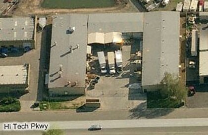
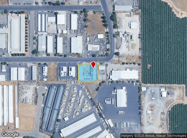
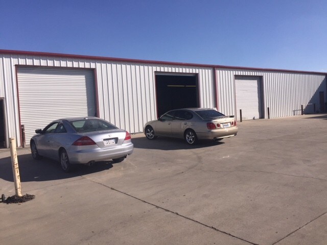
Property Record
667 Hi Tech Pky, Oakdale, CA 95361

NEARBY LISTINGS FOR SALE OR LEASE
Property Detail
667 Hi Tech Pky
Modesto, CA
As Shown On Parcel Map
064-39-41
26-PM-60 PARCEL 17 & 16
Warehouse
Stanislaus
X
California
06099C0190E
16&17
2025
0.83 AC
2025
Oakdale
000205
Stockton/Modesto
18,200 SF
DEMOGRAPHICS near 667 Hi Tech Pky
1 Mile
3 Mile
5 Mile
2024 Total Population
1,650
26,732
32,133
2029 Population
1,663
26,781
32,149
Pop Growth 2024-2029
+ 0.79%
+ 0.18%
+ 0.05%
Average Age
37
39
39
2024 Total Households
589
9,503
11,397
HH Growth 2024-2029
+ 0.85%
+ 0.15%
+ 0.02%
Median Household Inc
$66,455
$82,138
$85,672
Avg Household Size
2.80
2.80
2.80
2024 Avg HH Vehicles
2.00
2.00
2.00
Median Home Value
$419,396
$440,900
$463,666
Median Year Built
1996
1988
1986
Nearby Places
Map Layers
Map Styles
 Street
 Aerial
- Restaurants
- Banks
- Shops
- Fitness
- Groceries
PUBLIC TRANSPORTATION
AIRPORT
Stockton Metro
DRIVE
WALK
Distance
Stockton Metro
47 min
28.1 mi
Freight Ports
Port of Stockton
DRIVE
WALK
Distance
Port of Stockton
57 min
39.0 mi
SALE & LEASE HISTORY
LISTING DATE
SALE/LEASE

Nov 30, 2017
For Lease
Nearby Properties
Address
Land Use
TOTAL SIZE
Lot Size
Zoning
Address
Land Use
TOTAL SIZE
Lot Size
Zoning
330,747 SF
26.73 AC
OAKLM
Address
Land Use
TOTAL SIZE
Lot Size
Zoning
87,612 SF
4.15 AC
OAKC2
Address
Land Use
TOTAL SIZE
Lot Size
Zoning
543,278 SF
71.53 AC
Address
Land Use
TOTAL SIZE
Lot Size
Zoning
51,000 SF
0.99 AC
Address
Land Use
TOTAL SIZE
Lot Size
Zoning
230,148 SF
13.25 AC
MI
Address
Land Use
TOTAL SIZE
Lot Size
Zoning
49,200 SF
13.94 AC
Address
Land Use
TOTAL SIZE
Lot Size
Zoning
95,020 SF
9.82 AC
OAKPD
Address
Land Use
TOTAL SIZE
Lot Size
Zoning
151,200 SF
8.60 AC
MI
Address
Land Use
TOTAL SIZE
Lot Size
Zoning
86,946 SF
4.83 AC
OAKPD
Address
Land Use
TOTAL SIZE
Lot Size
Zoning
45,337 SF
3.97 AC
OAKPSP
Address
Land Use
TOTAL SIZE
Lot Size
Zoning
96,550 SF
4.05 AC
Address
Land Use
TOTAL SIZE
Lot Size
Zoning
117,162 SF
5.17 AC
Address
Land Use
TOTAL SIZE
Lot Size
Zoning
190,416 SF
5.93 AC
Address
Land Use
TOTAL SIZE
Lot Size
Zoning
11,411 SF
133.33 AC
COURA
Address
Land Use
TOTAL SIZE
Lot Size
Zoning
23,618 SF
2.93 AC
OAKPSP
Address
Land Use
TOTAL SIZE
Lot Size
Zoning
37,998 SF
2.80 AC
Address
Land Use
TOTAL SIZE
Lot Size
Zoning
15,114 SF
1.17 AC
Address
Land Use
TOTAL SIZE
Lot Size
Zoning
1.44 AC
OAKLM
Address
Land Use
TOTAL SIZE
Lot Size
Zoning
48,460 SF
5.64 AC
Address
Land Use
TOTAL SIZE
Lot Size
Zoning
78,731 SF
3.91 AC
Address
Land Use
TOTAL SIZE
Lot Size
Zoning
133,627 SF
13.33 AC
Address
Land Use
TOTAL SIZE
Lot Size
Zoning
86,549 SF
7.34 AC
Address
Land Use
TOTAL SIZE
Lot Size
Zoning
34,331 SF
1.70 AC
OAKC2
Address
Land Use
TOTAL SIZE
Lot Size
Zoning
12,861 SF
1.34 AC
OAKC2
Address
Land Use
TOTAL SIZE
Lot Size
Zoning
25,575 SF
4.86 AC
C2
Address
Land Use
TOTAL SIZE
Lot Size
Zoning
69,323 SF
3.77 AC
M
Address
Land Use
TOTAL SIZE
Lot Size
Zoning
816 SF
156.30 AC
A240
Address
Land Use
TOTAL SIZE
Lot Size
Zoning
50,250 SF
5.26 AC
OAKR2
Address
Land Use
TOTAL SIZE
Lot Size
Zoning
47,375 SF
2 AC
Address
Land Use
TOTAL SIZE
Lot Size
Zoning
2,456 SF
119.58 AC
A240
The World's #1 Commercial Real Estate Marketplace
Connect with us
© 2025 CoStar Group
The information above has been obtained from sources believed reliable. While we do not doubt its accuracy we have not verified it and make no guarantee, warranty or representation about it. It is your responsibility to independently confirm its accuracy and completeness. Any projections, opinions, assumptions, or estimates used are for example only and do not represent the current or future performance of the property. The value of this transaction to you depends on tax and other factors which should be evaluated by your tax, financial, and legal advisors. You and your advisors should conduct a careful, independent investigation of the property to determine to your satisfaction the suitability of the property for your needs.