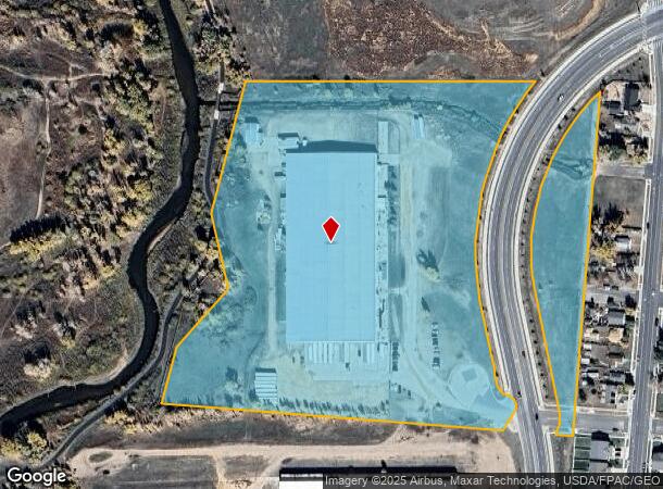
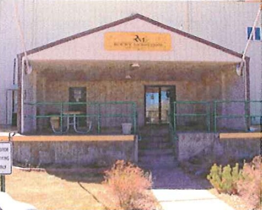
Property Record
667 W Flint St, Laramie, WY 82072

NEARBY LISTINGS FOR SALE OR LEASE
Property Detail
667 W Flint St
Laramie, WY
Pulte Indust Site
05-1673-32-1-05-004.00
PULTE IND SITE B 1 L 1 LESS TR IN W2 OF L 16-73-32 TR IN (VACATED PULTE IND SITE B 1 L 2-6) SICN 809-24 PULTE INDUSTRIAL SITE; LESS 3.05 AC TO NEW HARNEY ST OVERPASS TOTAL SF: 801557
Warehouse
Albany
AE
Wyoming
56001C1755E
1
2024
18.40 AC
2025
Downtown Laramie
962900
Other Market Areas
122,400 SF
DEMOGRAPHICS near 667 W Flint St
1 Mile
3 Mile
5 Mile
2024 Total Population
5,823
30,755
34,749
2029 Population
6,096
32,148
36,337
Pop Growth 2024-2029
+ 4.69%
+ 4.53%
+ 4.57%
Average Age
35
34
34
2024 Total Households
2,982
13,290
14,914
HH Growth 2024-2029
+ 4.76%
+ 4.88%
+ 4.91%
Median Household Inc
$38,091
$44,067
$46,877
Avg Household Size
1.90
2.10
2.10
2024 Avg HH Vehicles
2.00
2.00
2.00
Median Home Value
$174,932
$259,590
$275,206
Median Year Built
1964
1976
1977
Nearby Places
Map Layers
Map Styles
 Street
 Aerial
- Restaurants
- Banks
- Shops
- Fitness
- Groceries
Nearby Properties
Address
Land Use
TOTAL SIZE
Lot Size
Zoning
Address
Land Use
TOTAL SIZE
Lot Size
Zoning
184,618 SF
0.62 AC
Address
Land Use
TOTAL SIZE
Lot Size
Zoning
279,138 SF
20.10 AC
Address
Land Use
TOTAL SIZE
Lot Size
Zoning
129,760 SF
4.15 AC
Address
Land Use
TOTAL SIZE
Lot Size
Zoning
173,512 SF
6.36 AC
Address
Land Use
TOTAL SIZE
Lot Size
Zoning
164,069 SF
9.62 AC
Address
Land Use
TOTAL SIZE
Lot Size
Zoning
167,415 SF
12.68 AC
Address
Land Use
TOTAL SIZE
Lot Size
Zoning
55,547 SF
5.48 AC
Address
Land Use
TOTAL SIZE
Lot Size
Zoning
190,796 SF
11.18 AC
Address
Land Use
TOTAL SIZE
Lot Size
Zoning
131,020 SF
8.54 AC
Address
Land Use
TOTAL SIZE
Lot Size
Zoning
48,116 SF
5.63 AC
Address
Land Use
TOTAL SIZE
Lot Size
Zoning
67,335 SF
4.18 AC
Address
Land Use
TOTAL SIZE
Lot Size
Zoning
24,164 SF
2.56 AC
Address
Land Use
TOTAL SIZE
Lot Size
Zoning
85,866 SF
35.47 AC
Address
Land Use
TOTAL SIZE
Lot Size
Zoning
31,255 SF
5.12 AC
Address
Land Use
TOTAL SIZE
Lot Size
Zoning
57,539 SF
1.70 AC
Address
Land Use
TOTAL SIZE
Lot Size
Zoning
147,598 SF
10.25 AC
Address
Land Use
TOTAL SIZE
Lot Size
Zoning
57,916 SF
40.14 AC
Address
Land Use
TOTAL SIZE
Lot Size
Zoning
44,728 SF
2.50 AC
Address
Land Use
TOTAL SIZE
Lot Size
Zoning
333,540 SF
22.20 AC
Address
Land Use
TOTAL SIZE
Lot Size
Zoning
43,200 SF
2.22 AC
Address
Land Use
TOTAL SIZE
Lot Size
Zoning
61,240 SF
1.32 AC
Address
Land Use
TOTAL SIZE
Lot Size
Zoning
109,672 SF
3.13 AC
Address
Land Use
TOTAL SIZE
Lot Size
Zoning
2,401 SF
27.27 AC
Address
Land Use
TOTAL SIZE
Lot Size
Zoning
58,752 SF
1.35 AC
Address
Land Use
TOTAL SIZE
Lot Size
Zoning
64,632 SF
5.89 AC
Address
Land Use
TOTAL SIZE
Lot Size
Zoning
72,020 SF
2.89 AC
Address
Land Use
TOTAL SIZE
Lot Size
Zoning
41,961 SF
7.27 AC
Address
Land Use
TOTAL SIZE
Lot Size
Zoning
61,241 SF
3.99 AC
Address
Land Use
TOTAL SIZE
Lot Size
Zoning
51,466 SF
1.86 AC
Address
Land Use
TOTAL SIZE
Lot Size
Zoning
50,980 SF
1.26 AC
The World's #1 Commercial Real Estate Marketplace
Connect with us
© 2026 CoStar Group
The information above has been obtained from sources believed reliable. While we do not doubt its accuracy we have not verified it and make no guarantee, warranty or representation about it. It is your responsibility to independently confirm its accuracy and completeness. Any projections, opinions, assumptions, or estimates used are for example only and do not represent the current or future performance of the property. The value of this transaction to you depends on tax and other factors which should be evaluated by your tax, financial, and legal advisors. You and your advisors should conduct a careful, independent investigation of the property to determine to your satisfaction the suitability of the property for your needs.