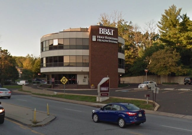
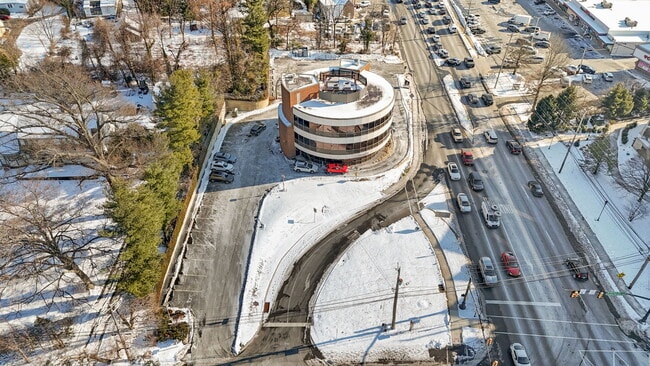
Property Record
667 Welsh Rd, Huntingdon Valley, PA 19006


NEARBY LISTINGS FOR SALE OR LEASE
Property Detail
667 Welsh Rd
Philadelphia-Camden-Wilmington, PA-NJ-DE-MD
Penllyn Homes
41-00-10009-003
ASSESSOR BLOCK-UNIT NUMBER 23-30
Officebuilding
Montgomery
AE
Pennsylvania
42091C0402G
30
2024
1.48 AC
2025
Horsham/Willow Grove
200106
Philadelphia
11,340 SF
DEMOGRAPHICS near 667 Welsh Rd
1 Mile
3 Mile
5 Mile
2024 Total Population
6,100
96,620
332,571
2029 Population
6,167
94,836
327,951
Pop Growth 2024-2029
+ 1.10%
(1.85%)
(1.39%)
Average Age
47
43
42
2024 Total Households
2,419
36,105
128,468
HH Growth 2024-2029
+ 0.83%
(2.14%)
(1.49%)
Median Household Inc
$91,820
$85,283
$80,368
Avg Household Size
2.40
2.60
2.50
2024 Avg HH Vehicles
2.00
2.00
2.00
Median Home Value
$487,830
$343,364
$300,925
Median Year Built
1967
1965
1962
Nearby Places
Map Layers
Map Styles
 Street
 Aerial
- Restaurants
- Banks
- Shops
- Fitness
- Groceries
PUBLIC TRANSPORTATION
TRANSIT/SUBWAY
Bethayres (R3 - Southeastern Pennsylvania Transportation Authority Regional Rail (SEPTA Regional Rail))
DRIVE
WALK
Distance
Bethayres (R3 - Southeastern Pennsylvania Transportation Authority Regional Rail (SEPTA Regional Rail))
3 min
7 min
0.4 mi
COMMUTER RAIL
Bethayres (R3 - Southeastern Pennsylvania Transportation Authority Regional Rail (SEPTA Regional Rail))
DRIVE
WALK
Distance
Bethayres (R3 - Southeastern Pennsylvania Transportation Authority Regional Rail (SEPTA Regional Rail))
3 min
7 min
0.4 mi
Philmont (R3 - Southeastern Pennsylvania Transportation Authority Regional Rail (SEPTA Regional Rail))
DRIVE
WALK
Distance
Philmont (R3 - Southeastern Pennsylvania Transportation Authority Regional Rail (SEPTA Regional Rail))
5 min
1.6 mi
AIRPORT
Trenton Mercer
DRIVE
WALK
Distance
Trenton Mercer
36 min
22.4 mi
Philadelphia International
DRIVE
WALK
Distance
Philadelphia International
47 min
26.9 mi
Freight Ports
Port of Philadelphia
DRIVE
WALK
Distance
Port of Philadelphia
20 min
11.3 mi
SALE & LEASE HISTORY
LISTING DATE
SALE/LEASE

Jun 30, 2023
For Sale
Feb 05, 2025
For Sale
Nearby Properties
Address
Land Use
TOTAL SIZE
Lot Size
Zoning
Address
Land Use
TOTAL SIZE
Lot Size
Zoning
1,556,628 SF
7.70 AC
AO
Address
Land Use
TOTAL SIZE
Lot Size
Zoning
17,563 SF
1.60 AC
C-O-2.5
Address
Land Use
TOTAL SIZE
Lot Size
Zoning
627,076 SF
36.89 AC
RSA1
Address
Land Use
TOTAL SIZE
Lot Size
Zoning
385,557 SF
5.10 AC
V
Address
Land Use
TOTAL SIZE
Lot Size
Zoning
325,000 SF
12.47 AC
RMX1
Address
Land Use
TOTAL SIZE
Lot Size
Zoning
406,343 SF
6.59 AC
V
Address
Land Use
TOTAL SIZE
Lot Size
Zoning
403,010 SF
9 AC
SPINS
Address
Land Use
TOTAL SIZE
Lot Size
Zoning
636,126 SF
43.18 AC
AP
Address
Land Use
TOTAL SIZE
Lot Size
Zoning
43.93 AC
RSD1
Address
Land Use
TOTAL SIZE
Lot Size
Zoning
184,500 SF
5.40 AC
RSD3
Address
Land Use
TOTAL SIZE
Lot Size
Zoning
166,782 SF
8.45 AC
RSD3
Address
Land Use
TOTAL SIZE
Lot Size
Zoning
309,000 SF
0.14 AC
RM2
Address
Land Use
TOTAL SIZE
Lot Size
Zoning
498,072 SF
5.39 AC
TC1
Address
Land Use
TOTAL SIZE
Lot Size
Zoning
557,091 SF
21.87 AC
AO
Address
Land Use
TOTAL SIZE
Lot Size
Zoning
179,718 SF
6.61 AC
RM2
Address
Land Use
TOTAL SIZE
Lot Size
Zoning
223,170 SF
6.41 AC
RM2
Address
Land Use
TOTAL SIZE
Lot Size
Zoning
282,292 SF
74.30 AC
IN
Address
Land Use
TOTAL SIZE
Lot Size
Zoning
136.16 AC
I2
Address
Land Use
TOTAL SIZE
Lot Size
Zoning
27.59 AC
SPPOA
Address
Land Use
TOTAL SIZE
Lot Size
Zoning
12,880 SF
1.15 AC
RSD1
Address
Land Use
TOTAL SIZE
Lot Size
Zoning
225,400 SF
7.40 AC
RM2
Address
Land Use
TOTAL SIZE
Lot Size
Zoning
11.36 AC
RSD1
Address
Land Use
TOTAL SIZE
Lot Size
Zoning
259,505 SF
42.19 AC
V
Address
Land Use
TOTAL SIZE
Lot Size
Zoning
157,400 SF
7.61 AC
RM2
Address
Land Use
TOTAL SIZE
Lot Size
Zoning
130,115 SF
10.45 AC
PB
Address
Land Use
TOTAL SIZE
Lot Size
Zoning
139,087 SF
2.76 AC
V
Address
Land Use
TOTAL SIZE
Lot Size
Zoning
97,022 SF
9.39 AC
CA2
Address
Land Use
TOTAL SIZE
Lot Size
Zoning
67,878 SF
11.54 AC
RSD3
Address
Land Use
TOTAL SIZE
Lot Size
Zoning
251,935 SF
13.03 AC
TC1
Address
Land Use
TOTAL SIZE
Lot Size
Zoning
193,334 SF
32.50 AC
NR
The World's #1 Commercial Real Estate Marketplace
Connect with us
© 2025 CoStar Group
The information above has been obtained from sources believed reliable. While we do not doubt its accuracy we have not verified it and make no guarantee, warranty or representation about it. It is your responsibility to independently confirm its accuracy and completeness. Any projections, opinions, assumptions, or estimates used are for example only and do not represent the current or future performance of the property. The value of this transaction to you depends on tax and other factors which should be evaluated by your tax, financial, and legal advisors. You and your advisors should conduct a careful, independent investigation of the property to determine to your satisfaction the suitability of the property for your needs.