Property Record
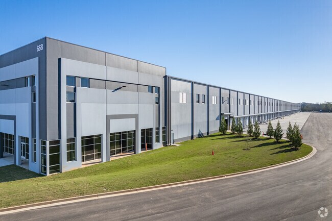
668 Thomas Pkwy, Jefferson, GA 30549


Property Detail
668 Thomas Pkwy
065-002N
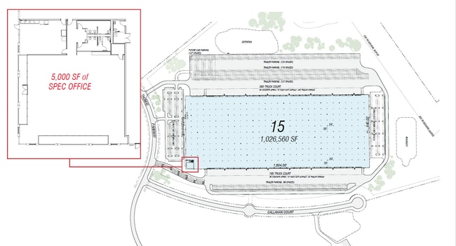
LOT 15 MCCLURE INDUSTR PK PB 81 PG 284
Distributionwarehouseregional
JACKSON
LI
Georgia
B and X Area of moderate flood hazard, usually the area between the limits of the 100-year and 500-year floods.
15
2025
105.41 AC
2025
E Jackson
010704
Atlanta
1,040,000 SF
Jefferson, GA
NEARBY LISTINGS FOR SALE OR LEASE
DEMOGRAPHICS near 668 Thomas Pkwy
1 mile
3 mile
5 mile
2025 Total Population
1,088
6,400
24,517
2030 Population
1,278
7,520
29,065
Pop Growth 2025-2030
+ 17.46%
+ 17.50%
+ 18.55%
Average Age
36
38
38
2025 Total Households
360
2,099
8,145
HH Growth 2025-2030
+ 17.50%
+ 17.68%
+ 18.70%
Median Household Inc
$94,223
$97,086
$89,327
Avg Household Size
2.90
2.90
2.90
2025 Avg HH Vehicles
3.00
3.00
2.00
Median Home Value
$389,223
$370,016
$362,091
Median Year Built
2006
2002
2003
Nearby Places
Map Layers
Map Styles
 Street
 Aerial
Transit
 Traffic
 Biking
Places
Listings with unknown addresses are not visible on the map
- Restaurants
- Banks
- Shops
- Fitness
- Groceries
SALE & LEASE HISTORY
LISTING DATE
SALE/LEASE

Mar 03, 2021
For Lease
Aug 04, 2025
For Lease
Nearby Properties
Address
Land Use
TOTAL SIZE
Lot Size
Zoning
Address
Land Use
TOTAL SIZE
Lot Size
Zoning
1,131,000 SF
94.67 AC
LI
Address
Land Use
TOTAL SIZE
Lot Size
Zoning
1,016,631 SF
65.03 AC
LI
Address
Land Use
TOTAL SIZE
Lot Size
Zoning
1,004,400 SF
61.31 AC
L1
Address
Land Use
TOTAL SIZE
Lot Size
Zoning
458,640 SF
54.96 AC
MI
Address
Land Use
TOTAL SIZE
Lot Size
Zoning
772,000 SF
86.10 AC
LI
Address
Land Use
TOTAL SIZE
Lot Size
Zoning
339,207 SF
65.25 AC
MI
Address
Land Use
TOTAL SIZE
Lot Size
Zoning
815,112 SF
104.67 AC
LI
Address
Land Use
TOTAL SIZE
Lot Size
Zoning
820,800 SF
46.50 AC
LI
Address
Land Use
TOTAL SIZE
Lot Size
Zoning
73,137 SF
18.79 AC
R1
Address
Land Use
TOTAL SIZE
Lot Size
Zoning
404,608 SF
52.95 AC
M1
Address
Land Use
TOTAL SIZE
Lot Size
Zoning
719,200 SF
113.14 AC
M1
Address
Land Use
TOTAL SIZE
Lot Size
Zoning
749,700 SF
44.96 AC
LI
Address
Land Use
TOTAL SIZE
Lot Size
Zoning
366,300 SF
123.06 AC
I2
Address
Land Use
TOTAL SIZE
Lot Size
Zoning
498,160 SF
45.63 AC
LI
Address
Land Use
TOTAL SIZE
Lot Size
Zoning
850,500 SF
57.87 AC
I
Address
Land Use
TOTAL SIZE
Lot Size
Zoning
147.44 AC
MI
Address
Land Use
TOTAL SIZE
Lot Size
Zoning
518,500 SF
35.05 AC
LI
Address
Land Use
TOTAL SIZE
Lot Size
Zoning
916,560 SF
82.80 AC
004
Address
Land Use
TOTAL SIZE
Lot Size
Zoning
848,000 SF
60.86 AC
I2
Address
Land Use
TOTAL SIZE
Lot Size
Zoning
458,655 SF
37.64 AC
003
Address
Land Use
TOTAL SIZE
Lot Size
Zoning
242,306 SF
32.76 AC
I2
Address
Land Use
TOTAL SIZE
Lot Size
Zoning
518,125 SF
28.51 AC
I2
Address
Land Use
TOTAL SIZE
Lot Size
Zoning
105,060 SF
14.39 AC
Address
Land Use
TOTAL SIZE
Lot Size
Zoning
502,156 SF
85.32 AC
LI-C2
Address
Land Use
TOTAL SIZE
Lot Size
Zoning
140,996 SF
29.69 AC
LI
Address
Land Use
TOTAL SIZE
Lot Size
Zoning
195,200 SF
14.37 AC
003
Address
Land Use
TOTAL SIZE
Lot Size
Zoning
202.89 AC
GI
Address
Land Use
TOTAL SIZE
Lot Size
Zoning
146.79 AC
MI
Address
Land Use
TOTAL SIZE
Lot Size
Zoning
189,112 SF
21.27 AC
LI
The World's #1 Commercial Real Estate Marketplace
Connect with us
© 2026 CoStar Group
The information above has been obtained from sources believed reliable. While we do not doubt its accuracy we have not verified it and make no guarantee, warranty or representation about it. It is your responsibility to independently confirm its accuracy and completeness. Any projections, opinions, assumptions, or estimates used are for example only and do not represent the current or future performance of the property. The value of this transaction to you depends on tax and other factors which should be evaluated by your tax, financial, and legal advisors. You and your advisors should conduct a careful, independent investigation of the property to determine to your satisfaction the suitability of the property for your needs.