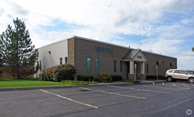
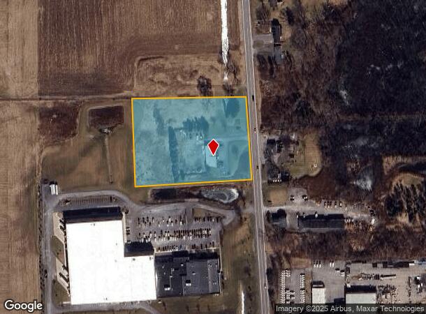
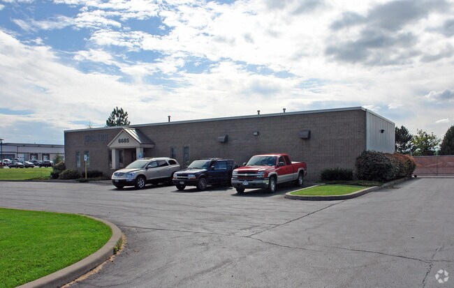
Property Record
6685 W Henrietta Rd, Rush, NY 14543
NEARBY LISTINGS FOR SALE OR LEASE
Property Detail
6685 W Henrietta Rd
263200-201-020-0002-013-112
LOCATION NO 000013 APP FACTOR 1.0000 HENRIETTA OFFICE
Privateutilityelectricwatergasnuclearsolarwindetc
Monroe
X
New York
36055C0343G
13.112
2025
3.75 AC
2024
South Central
013206
Rochester
3,600 SF
Rochester, NY
DEMOGRAPHICS near 6685 W Henrietta Rd
1 Mile
3 Mile
5 Mile
2024 Total Population
1,719
16,876
47,402
2029 Population
1,672
16,673
46,918
Pop Growth 2024-2029
(2.73%)
(1.20%)
(1.02%)
Average Age
41
41
38
2024 Total Households
657
6,519
16,752
HH Growth 2024-2029
(2.89%)
(1.24%)
(1.09%)
Median Household Inc
$112,030
$94,605
$76,281
Avg Household Size
2.60
2.50
2.40
2024 Avg HH Vehicles
2.00
2.00
2.00
Median Home Value
$200,754
$212,410
$181,304
Median Year Built
1987
1989
1977
Nearby Places
- Restaurants
- Banks
- Shops
- Fitness
- Groceries
PUBLIC TRANSPORTATION
AIRPORT
Frederick Douglass/Greater Rochester International
DRIVE
WALK
Distance
Frederick Douglass/Greater Rochester International
17 min
9.1 mi
Nearby Properties
Address
Land Use
TOTAL SIZE
Lot Size
Zoning
Address
Land Use
TOTAL SIZE
Lot Size
Zoning
2,440 SF
141.36 AC
06 - INDUS
Address
Land Use
TOTAL SIZE
Lot Size
Zoning
1,200 SF
34.17 AC
02 - SINGL
Address
Land Use
TOTAL SIZE
Lot Size
Zoning
364,000 SF
66.25 AC
06 - INDUS
Address
Land Use
TOTAL SIZE
Lot Size
Zoning
11,108 SF
57.55 AC
06 - INDUS
Address
Land Use
TOTAL SIZE
Lot Size
Zoning
361,112 SF
54.84 AC
02 - SINGL
Address
Land Use
TOTAL SIZE
Lot Size
Zoning
65.37 AC
02 - SINGL
Address
Land Use
TOTAL SIZE
Lot Size
Zoning
404,630 SF
21.44 AC
06 - INDUS
Address
Land Use
TOTAL SIZE
Lot Size
Zoning
600 SF
446.14 AC
07 - MIXED
Address
Land Use
TOTAL SIZE
Lot Size
Zoning
138,633 SF
16.80 AC
05 - COMME
Address
Land Use
TOTAL SIZE
Lot Size
Zoning
181,876 SF
11.64 AC
07 - MIXED
Address
Land Use
TOTAL SIZE
Lot Size
Zoning
68,569 SF
42 AC
02 - SINGL
Address
Land Use
TOTAL SIZE
Lot Size
Zoning
140,533 SF
63.50 AC
02 - SINGL
Address
Land Use
TOTAL SIZE
Lot Size
Zoning
4,442 SF
31 AC
02 - SINGL
Address
Land Use
TOTAL SIZE
Lot Size
Zoning
10,884 SF
17.63 AC
03 - MULTI
Address
Land Use
TOTAL SIZE
Lot Size
Zoning
10,865 SF
10.48 AC
02 - SINGL
Address
Land Use
TOTAL SIZE
Lot Size
Zoning
60,495 SF
12.12 AC
02 - SINGL
Address
Land Use
TOTAL SIZE
Lot Size
Zoning
9,932 SF
9.91 AC
02 - SINGL
Address
Land Use
TOTAL SIZE
Lot Size
Zoning
350,300 SF
34.12 AC
07 - MIXED
Address
Land Use
TOTAL SIZE
Lot Size
Zoning
137,716 SF
13.23 AC
06 - INDUS
Address
Land Use
TOTAL SIZE
Lot Size
Zoning
27.40 AC
R30
Address
Land Use
TOTAL SIZE
Lot Size
Zoning
101,250 SF
13.57 AC
06 - INDUS
Address
Land Use
TOTAL SIZE
Lot Size
Zoning
29,700 SF
5.06 AC
06 - INDUS
Address
Land Use
TOTAL SIZE
Lot Size
Zoning
57,328 SF
10.27 AC
05 - COMME
Address
Land Use
TOTAL SIZE
Lot Size
Zoning
60,967 SF
12.83 AC
06 - INDUS
Address
Land Use
TOTAL SIZE
Lot Size
Zoning
70,838 SF
14.40 AC
R30
Address
Land Use
TOTAL SIZE
Lot Size
Zoning
45,052 SF
6.78 AC
06 - INDUS
Address
Land Use
TOTAL SIZE
Lot Size
Zoning
54,132 SF
4.73 AC
06 - INDUS
Address
Land Use
TOTAL SIZE
Lot Size
Zoning
75,456 SF
6.68 AC
06 - INDUS
Address
Land Use
TOTAL SIZE
Lot Size
Zoning
47,322 SF
9.35 AC
06 - INDUS
Address
Land Use
TOTAL SIZE
Lot Size
Zoning
16,320 SF
2.21 AC
05 - COMME
The World's #1 Commercial Real Estate Marketplace
Connect with us
© 2025 CoStar Group
The information above has been obtained from sources believed reliable. While we do not doubt its accuracy we have not verified it and make no guarantee, warranty or representation about it. It is your responsibility to independently confirm its accuracy and completeness. Any projections, opinions, assumptions, or estimates used are for example only and do not represent the current or future performance of the property. The value of this transaction to you depends on tax and other factors which should be evaluated by your tax, financial, and legal advisors. You and your advisors should conduct a careful, independent investigation of the property to determine to your satisfaction the suitability of the property for your needs.