Property Record
6677 42Nd Ter N, Riviera Beach, FL 33407

Current Lease Availabilities
NEARBY LISTINGS FOR SALE OR LEASE
Property Detail
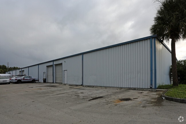
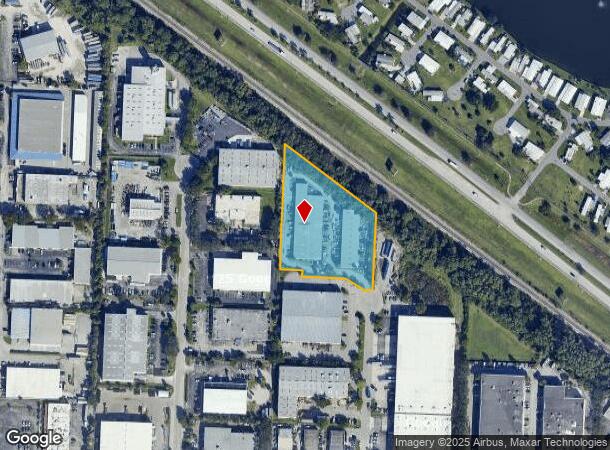
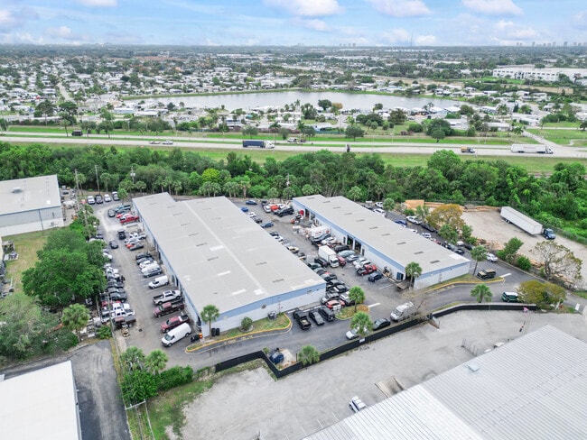
6677 42Nd Ter N
56-42-42-36-32-000-0000
Keller Fred Trustee
Warehouse
FRED KELLER TRUSTEE ALL OF PLAT
X
Palm Beach
12099C0388F
Florida
2024
2.63 AC
2024
Westroads Area
001002
South Florida
34,610 SF
West Palm Beach-Boca Raton-Delray Beach, FL
DEMOGRAPHICS near 6677 42Nd Ter N
1 Mile
3 Mile
5 Mile
2024 Total Population
9,481
84,348
218,758
2029 Population
10,203
88,216
229,750
Pop Growth 2024-2029
+ 7.62%
+ 4.59%
+ 5.02%
Average Age
39
38
43
2024 Total Households
3,340
30,035
92,869
HH Growth 2024-2029
+ 7.28%
+ 3.91%
+ 4.79%
Median Household Inc
$54,702
$58,935
$58,310
Avg Household Size
2.70
2.60
2.20
2024 Avg HH Vehicles
2.00
2.00
1.00
Median Home Value
$233,604
$257,619
$299,373
Median Year Built
1994
1988
1983
Nearby Places
- Restaurants
- Banks
- Shops
- Fitness
- Groceries
PUBLIC TRANSPORTATION
COMMUTER RAIL
Mangonia Park (Tri-County Commuter - South Florida Regional Transportation Authority (Tri-Rail))
DRIVE
WALK
Distance
Mangonia Park (Tri-County Commuter - South Florida Regional Transportation Authority (Tri-Rail))
10 min
4.3 mi
West Palm Beach (Tri-County Commuter - South Florida Regional Transportation Authority (Tri-Rail))
DRIVE
WALK
Distance
West Palm Beach (Tri-County Commuter - South Florida Regional Transportation Authority (Tri-Rail))
15 min
7.9 mi
AIRPORT
Palm Beach International
DRIVE
WALK
Distance
Palm Beach International
20 min
10.5 mi
Freight Ports
Port of Palm Beach
DRIVE
WALK
Distance
Port of Palm Beach
12 min
4.9 mi
Nearby Properties
Address
Land Use
TOTAL SIZE
Lot Size
Zoning
Address
Land Use
TOTAL SIZE
Lot Size
Zoning
1,778,741 SF
69.19 AC
CF
Address
Land Use
TOTAL SIZE
Lot Size
Zoning
650,167 SF
27.64 AC
PCD
Address
Land Use
TOTAL SIZE
Lot Size
Zoning
770,163 SF
571.53 AC
CS
Address
Land Use
TOTAL SIZE
Lot Size
Zoning
586,386 SF
19.67 AC
RPD
Address
Land Use
TOTAL SIZE
Lot Size
Zoning
546,847 SF
19.50 AC
RPD
Address
Land Use
TOTAL SIZE
Lot Size
Zoning
739,813 SF
81.18 AC
CSPD
Address
Land Use
TOTAL SIZE
Lot Size
Zoning
292,706 SF
30.75 AC
RPD
Address
Land Use
TOTAL SIZE
Lot Size
Zoning
411,080 SF
7.59 AC
CPD
Address
Land Use
TOTAL SIZE
Lot Size
Zoning
416,171 SF
19.24 AC
R-PUD
Address
Land Use
TOTAL SIZE
Lot Size
Zoning
224,212 SF
141.33 AC
CSPD
Address
Land Use
TOTAL SIZE
Lot Size
Zoning
23.07 AC
CLIC
Address
Land Use
TOTAL SIZE
Lot Size
Zoning
247,028 SF
14.30 AC
RS
Address
Land Use
TOTAL SIZE
Lot Size
Zoning
433,243 SF
40.26 AC
RM-15
Address
Land Use
TOTAL SIZE
Lot Size
Zoning
366,446 SF
67.91 AC
CPD
Address
Land Use
TOTAL SIZE
Lot Size
Zoning
307,554 SF
6.10 AC
CSPD
Address
Land Use
TOTAL SIZE
Lot Size
Zoning
314,993 SF
38.46 AC
CF
Address
Land Use
TOTAL SIZE
Lot Size
Zoning
416,165 SF
42.48 AC
CSPD
Address
Land Use
TOTAL SIZE
Lot Size
Zoning
215,592 SF
38.87 AC
RL3
Address
Land Use
TOTAL SIZE
Lot Size
Zoning
185,238 SF
16.63 AC
CLIC
Address
Land Use
TOTAL SIZE
Lot Size
Zoning
270,686 SF
56.14 AC
IG
Address
Land Use
TOTAL SIZE
Lot Size
Zoning
216,255 SF
25.37 AC
CSPD
Address
Land Use
TOTAL SIZE
Lot Size
Zoning
299,161 SF
16.85 AC
CSPD
Address
Land Use
TOTAL SIZE
Lot Size
Zoning
323,628 SF
48.15 AC
IG
Address
Land Use
TOTAL SIZE
Lot Size
Zoning
252,320 SF
29.12 AC
IG
Address
Land Use
TOTAL SIZE
Lot Size
Zoning
156,102 SF
10.80 AC
RPD
Address
Land Use
TOTAL SIZE
Lot Size
Zoning
290,846 SF
20.50 AC
IG
Address
Land Use
TOTAL SIZE
Lot Size
Zoning
251,720 SF
12.95 AC
IL
Address
Land Use
TOTAL SIZE
Lot Size
Zoning
116,383 SF
7.52 AC
PCD
Address
Land Use
TOTAL SIZE
Lot Size
Zoning
224,109 SF
6.56 AC
CSPD
Address
Land Use
TOTAL SIZE
Lot Size
Zoning
236,554 SF
14.37 AC
IG
The World's #1 Commercial Real Estate Marketplace
Connect with us
© 2025 CoStar Group
The information above has been obtained from sources believed reliable. While we do not doubt its accuracy we have not verified it and make no guarantee, warranty or representation about it. It is your responsibility to independently confirm its accuracy and completeness. Any projections, opinions, assumptions, or estimates used are for example only and do not represent the current or future performance of the property. The value of this transaction to you depends on tax and other factors which should be evaluated by your tax, financial, and legal advisors. You and your advisors should conduct a careful, independent investigation of the property to determine to your satisfaction the suitability of the property for your needs.