Property Record
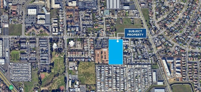
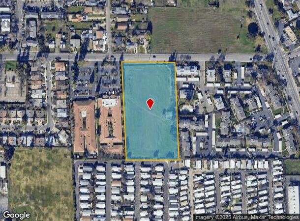
66Th Ave, Sacramento, CA 95823
This Property Is For Sale
NEARBY LISTINGS FOR SALE OR LEASE
Property Detail
66Th Ave
Sacramento--Roseville--Arden-Arcade, CA
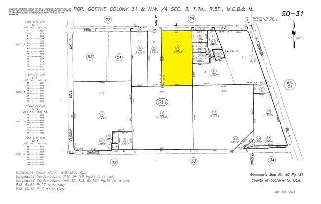
Parcel Map
050-0311-028
PARCEL MAP, LOT 2
Residentialacreage
Sacramento
X
California
06067C0306H
2
2024
4.39 AC
2025
South Sacramento
004910
Sacramento
DEMOGRAPHICS near 66Th Ave
1 Mile
3 Mile
5 Mile
2024 Total Population
24,576
182,409
390,254
2029 Population
24,541
182,072
389,756
Pop Growth 2024-2029
(0.14%)
(0.18%)
(0.13%)
Average Age
37
37
38
2024 Total Households
7,464
54,538
125,785
HH Growth 2024-2029
(0.20%)
(0.26%)
(0.17%)
Median Household Inc
$47,204
$56,677
$70,069
Avg Household Size
3.10
3.20
3.00
2024 Avg HH Vehicles
2.00
2.00
2.00
Median Home Value
$303,349
$332,568
$415,201
Median Year Built
1975
1978
1980
Nearby Places
- Restaurants
- Banks
- Shops
- Fitness
- Groceries
PUBLIC TRANSPORTATION
COMMUTER RAIL
Sacramento (Capitol Corridor - Capitol Corridor Joint Powers Authority)
DRIVE
WALK
Distance
Sacramento (Capitol Corridor - Capitol Corridor Joint Powers Authority)
15 min
9.2 mi
AIRPORT
Sacramento International
DRIVE
WALK
Distance
Sacramento International
29 min
20.0 mi
Freight Ports
Port of Stockton
DRIVE
WALK
Distance
Port of Stockton
54 min
44.9 mi
Nearby Properties
Address
Land Use
TOTAL SIZE
Lot Size
Zoning
Address
Land Use
TOTAL SIZE
Lot Size
Zoning
728,235 SF
29.15 AC
H-R
Address
Land Use
TOTAL SIZE
Lot Size
Zoning
2,317,288 SF
220.58 AC
M-2-SPD
Address
Land Use
TOTAL SIZE
Lot Size
Zoning
45.93 AC
M-2S
Address
Land Use
TOTAL SIZE
Lot Size
Zoning
303,529 SF
10.28 AC
R-3A-PUD R
Address
Land Use
TOTAL SIZE
Lot Size
Zoning
169,610 SF
11.49 AC
H-PUD
Address
Land Use
TOTAL SIZE
Lot Size
Zoning
187,080 SF
10.01 AC
SPA M-1
Address
Land Use
TOTAL SIZE
Lot Size
Zoning
40.67 AC
M-2-SPD
Address
Land Use
TOTAL SIZE
Lot Size
Zoning
198,112 SF
19.62 AC
M-1 M-1 (N
Address
Land Use
TOTAL SIZE
Lot Size
Zoning
7.55 AC
SPA
Address
Land Use
TOTAL SIZE
Lot Size
Zoning
281,404 SF
21.43 AC
M-2
Address
Land Use
TOTAL SIZE
Lot Size
Zoning
53,386 SF
7.75 AC
C-2-SPD
Address
Land Use
TOTAL SIZE
Lot Size
Zoning
249,868 SF
15.23 AC
R-2B-R
Address
Land Use
TOTAL SIZE
Lot Size
Zoning
0.12 AC
SPA
Address
Land Use
TOTAL SIZE
Lot Size
Zoning
261,350 SF
14.41 AC
M-2S
Address
Land Use
TOTAL SIZE
Lot Size
Zoning
319,485 SF
16.35 AC
M-2S
Address
Land Use
TOTAL SIZE
Lot Size
Zoning
213,445 SF
18.25 AC
SC
Address
Land Use
TOTAL SIZE
Lot Size
Zoning
158,710 SF
14.02 AC
M-1 (NPA)
Address
Land Use
TOTAL SIZE
Lot Size
Zoning
138,779 SF
44.77 AC
M-2S
Address
Land Use
TOTAL SIZE
Lot Size
Zoning
120,868 SF
53.03 AC
SPA
Address
Land Use
TOTAL SIZE
Lot Size
Zoning
135,197 SF
15.70 AC
LC
Address
Land Use
TOTAL SIZE
Lot Size
Zoning
55,344 SF
4.75 AC
M-2S
Address
Land Use
TOTAL SIZE
Lot Size
Zoning
86,094 SF
6.17 AC
H-PUD
Address
Land Use
TOTAL SIZE
Lot Size
Zoning
58.59 AC
R-1
Address
Land Use
TOTAL SIZE
Lot Size
Zoning
135,408 SF
13.31 AC
SC
Address
Land Use
TOTAL SIZE
Lot Size
Zoning
5.29 AC
M-2S
Address
Land Use
TOTAL SIZE
Lot Size
Zoning
144,849 SF
5.72 AC
R-3
Address
Land Use
TOTAL SIZE
Lot Size
Zoning
69,411 SF
7.21 AC
OB
Address
Land Use
TOTAL SIZE
Lot Size
Zoning
109,532 SF
5.03 AC
R-3
Address
Land Use
TOTAL SIZE
Lot Size
Zoning
50,729 SF
12.30 AC
H-R
Address
Land Use
TOTAL SIZE
Lot Size
Zoning
138,561 SF
17.27 AC
SC
The World's #1 Commercial Real Estate Marketplace
Connect with us
© 2025 CoStar Group
The information above has been obtained from sources believed reliable. While we do not doubt its accuracy we have not verified it and make no guarantee, warranty or representation about it. It is your responsibility to independently confirm its accuracy and completeness. Any projections, opinions, assumptions, or estimates used are for example only and do not represent the current or future performance of the property. The value of this transaction to you depends on tax and other factors which should be evaluated by your tax, financial, and legal advisors. You and your advisors should conduct a careful, independent investigation of the property to determine to your satisfaction the suitability of the property for your needs.