Property Record
66Th St, Ocean City, MD 21842

Save to a Folder
{{folder.Name}}
{{folder.ListingIds.length}} Properties
{{folder.ListingIds.length}} Property
Create a New Folder
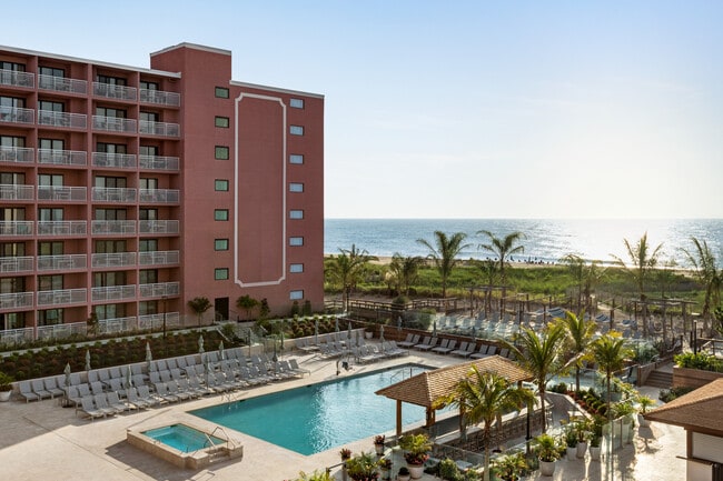
Property Detail
66Th St
10-246202
PARCEL 34A 118899 SQ FT COR COASTAL & 66TH ST SUBDIV OF 34A & 34B
Hotel
WORCESTER
R-3
Maryland
B and X Area of moderate flood hazard, usually the area between the limits of the 100-year and 500-year floods.
34a
2025
0.34 AC
2025
Ocean City
950100
Other Market Areas
120,184 SF
Ocean Pines, MD
NEARBY LISTINGS FOR SALE OR LEASE
-
-
View all Ocean City listings for sale on LoopNet.com
DEMOGRAPHICS near 66Th St
1 mile
3 mile
5 mile
2025 Total Population
3,714
15,544
34,096
2030 Population
4,407
18,280
37,886
Pop Growth 2025-2030
+ 18.66%
+ 17.60%
+ 11.12%
Average Age
50
51
50
2025 Total Households
1,918
8,115
16,692
HH Growth 2025-2030
+ 18.20%
+ 17.15%
+ 11.11%
Median Household Inc
$85,207
$83,190
$83,204
Avg Household Size
1.70
1.80
1.90
2025 Avg HH Vehicles
2.00
2.00
2.00
Median Home Value
$433,177
$422,040
$426,132
Median Year Built
1984
1982
1983
Nearby Places
Map Layers
Map Styles
 Street
 Aerial
Layers
 Traffic
 Biking
Places
Listings with unknown addresses are not visible on the map
- Restaurants
- Banks
- Shops
- Fitness
- Groceries
PUBLIC TRANSPORTATION
AIRPORT
Salisbury-Ocean City Wicomico Regional
Drive
Walk
Distance
Salisbury-Ocean City Wicomico Regional
47 min
29.5 mi
Freight Ports
Port of Wilmington, RI
Drive
Walk
Distance
Port of Wilmington, RI
154 min
116.6 mi
Nearby Properties
Address
Land Use
TOTAL SIZE
Lot Size
Zoning
Address
Land Use
TOTAL SIZE
Lot Size
Zoning
249,984 SF
2.24 AC
R-3
Address
Land Use
TOTAL SIZE
Lot Size
Zoning
34,402 SF
2.07 AC
R-3
Address
Land Use
TOTAL SIZE
Lot Size
Zoning
524 SF
0.72 AC
R3
Address
Land Use
TOTAL SIZE
Lot Size
Zoning
198,904 SF
3.39 AC
R-2
Address
Land Use
TOTAL SIZE
Lot Size
Zoning
182,200 SF
11.31 AC
LC-1
Address
Land Use
TOTAL SIZE
Lot Size
Zoning
41,643 SF
57.82 AC
R-2
Address
Land Use
TOTAL SIZE
Lot Size
Zoning
115,544 SF
1.03 AC
R-2
Address
Land Use
TOTAL SIZE
Lot Size
Zoning
128,933 SF
3.88 AC
LC-1
Address
Land Use
TOTAL SIZE
Lot Size
Zoning
111,993 SF
1.02 AC
R-3
Address
Land Use
TOTAL SIZE
Lot Size
Zoning
63,159 SF
3.98 AC
LC-1
Address
Land Use
TOTAL SIZE
Lot Size
Zoning
73,508 SF
2.14 AC
SC1
Address
Land Use
TOTAL SIZE
Lot Size
Zoning
103,230 SF
1.03 AC
R-3
Address
Land Use
TOTAL SIZE
Lot Size
Zoning
145,813 SF
1.03 AC
R-3
Address
Land Use
TOTAL SIZE
Lot Size
Zoning
120,184 SF
2.73 AC
R-3
Address
Land Use
TOTAL SIZE
Lot Size
Zoning
40,816 SF
9.64 AC
LC-1
Address
Land Use
TOTAL SIZE
Lot Size
Zoning
73,088 SF
1.05 AC
R-3
Address
Land Use
TOTAL SIZE
Lot Size
Zoning
61,455 SF
1.03 AC
LC-1
Address
Land Use
TOTAL SIZE
Lot Size
Zoning
38,109 SF
0.49 AC
R-3
Address
Land Use
TOTAL SIZE
Lot Size
Zoning
20,640 SF
2.83 AC
R-3
Address
Land Use
TOTAL SIZE
Lot Size
Zoning
50,886 SF
1.44 AC
LC-1
Address
Land Use
TOTAL SIZE
Lot Size
Zoning
4,212 SF
3.60 AC
LC-1
Address
Land Use
TOTAL SIZE
Lot Size
Zoning
78,367 SF
3.15 AC
LC-1
Address
Land Use
TOTAL SIZE
Lot Size
Zoning
11,400 SF
0.60 AC
R-3
Address
Land Use
TOTAL SIZE
Lot Size
Zoning
11,665 SF
22.70 AC
BMUD
Address
Land Use
TOTAL SIZE
Lot Size
Zoning
57,073 SF
1.27 AC
BMUD
Address
Land Use
TOTAL SIZE
Lot Size
Zoning
39,438 SF
1.03 AC
R-3
Address
Land Use
TOTAL SIZE
Lot Size
Zoning
4,613 SF
11.48 AC
LC-1
Address
Land Use
TOTAL SIZE
Lot Size
Zoning
35,070 SF
11.76 AC
LC-1
Address
Land Use
TOTAL SIZE
Lot Size
Zoning
99,056 SF
9.64 AC
R-2
Address
Land Use
TOTAL SIZE
Lot Size
Zoning
27,000 SF
0.65 AC
R-3
The World's #1 Commercial Real Estate Marketplace
Connect with us
© 2026 CoStar Group
The information above has been obtained from sources believed reliable. While we do not doubt its accuracy we have not verified it and make no guarantee, warranty or representation about it. It is your responsibility to independently confirm its accuracy and completeness. Any projections, opinions, assumptions, or estimates used are for example only and do not represent the current or future performance of the property. The value of this transaction to you depends on tax and other factors which should be evaluated by your tax, financial, and legal advisors. You and your advisors should conduct a careful, independent investigation of the property to determine to your satisfaction the suitability of the property for your needs.