Property Record
67 1/2 Us Route 20, Seneca Falls, NY 13148
NEARBY LISTINGS FOR SALE OR LEASE
-
-
View all Seneca Falls listings for sale on LoopNet.com
Property Detail
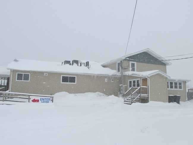
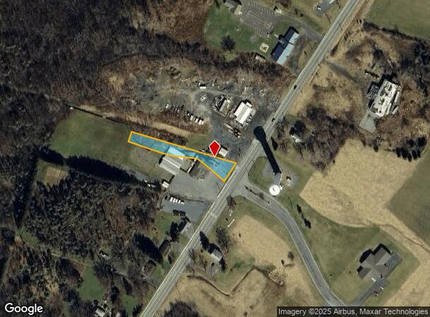
67 1/2 Us Route 20
Seneca Falls, NY
Seneca
453289-002-000-0001-009-002-0000
New York
Restaurantdrivein
9.002
2025
0.60 AC
2024
Ithaca/Elmira
950200
Other Market Areas
768 SF
DEMOGRAPHICS near 67 1/2 Us Route 20
1 Mile
3 Mile
5 Mile
2024 Total Population
1,884
8,497
16,224
2029 Population
1,837
8,355
15,927
Pop Growth 2024-2029
(2.49%)
(1.67%)
(1.83%)
Average Age
43
42
43
2024 Total Households
826
3,775
7,004
HH Growth 2024-2029
(2.66%)
(1.83%)
(1.91%)
Median Household Inc
$64,232
$54,559
$58,675
Avg Household Size
2.20
2.20
2.20
2024 Avg HH Vehicles
2.00
2.00
2.00
Median Home Value
$120,602
$119,723
$120,252
Median Year Built
1947
1950
1953
Nearby Places
- Restaurants
- Banks
- Shops
- Fitness
- Groceries
SALE & LEASE HISTORY
LISTING DATE
SALE/LEASE

Sep 24, 2016
For Sale
Oct 14, 2020
For Sale
Oct 04, 2017
For Sale
Nearby Properties
Address
Land Use
TOTAL SIZE
Lot Size
Zoning
Address
Land Use
TOTAL SIZE
Lot Size
Zoning
61,788 SF
189.70 AC
A-1
Address
Land Use
TOTAL SIZE
Lot Size
Zoning
303,436 SF
67.40 AC
Address
Land Use
TOTAL SIZE
Lot Size
Zoning
163,212 SF
27.40 AC
R-1
Address
Land Use
TOTAL SIZE
Lot Size
Zoning
49,986 SF
1.30 AC
C-2
Address
Land Use
TOTAL SIZE
Lot Size
Zoning
154,484 SF
20.20 AC
C-2
Address
Land Use
TOTAL SIZE
Lot Size
Zoning
14,673 SF
1.30 AC
C-2
Address
Land Use
TOTAL SIZE
Lot Size
Zoning
Address
Land Use
TOTAL SIZE
Lot Size
Zoning
117,998 SF
17.80 AC
C-2
Address
Land Use
TOTAL SIZE
Lot Size
Zoning
30,000 SF
5 AC
M-R
Address
Land Use
TOTAL SIZE
Lot Size
Zoning
19,154 SF
102.20 AC
C-2
Address
Land Use
TOTAL SIZE
Lot Size
Zoning
1 AC
L-C
Address
Land Use
TOTAL SIZE
Lot Size
Zoning
2,450 SF
43.20 AC
L-C
Address
Land Use
TOTAL SIZE
Lot Size
Zoning
5,269 SF
2.90 AC
R-1
Address
Land Use
TOTAL SIZE
Lot Size
Zoning
19,900 SF
13.20 AC
C-2
Address
Land Use
TOTAL SIZE
Lot Size
Zoning
83.50 AC
M-2
Address
Land Use
TOTAL SIZE
Lot Size
Zoning
25,769 SF
0.67 AC
C-1
Address
Land Use
TOTAL SIZE
Lot Size
Zoning
30,200 SF
25 AC
C-2
Address
Land Use
TOTAL SIZE
Lot Size
Zoning
48,048 SF
1.88 AC
C-2
Address
Land Use
TOTAL SIZE
Lot Size
Zoning
0.52 AC
R-1
Address
Land Use
TOTAL SIZE
Lot Size
Zoning
24,018 SF
3.10 AC
C-2
Address
Land Use
TOTAL SIZE
Lot Size
Zoning
109,615 SF
8.30 AC
C-2
Address
Land Use
TOTAL SIZE
Lot Size
Zoning
78,312 SF
15.90 AC
C-2
Address
Land Use
TOTAL SIZE
Lot Size
Zoning
11,500 SF
2 AC
R-1
Address
Land Use
TOTAL SIZE
Lot Size
Zoning
Address
Land Use
TOTAL SIZE
Lot Size
Zoning
98,670 SF
8.56 AC
M-1
Address
Land Use
TOTAL SIZE
Lot Size
Zoning
29,503 SF
5 AC
R-1
Address
Land Use
TOTAL SIZE
Lot Size
Zoning
Address
Land Use
TOTAL SIZE
Lot Size
Zoning
38,812 SF
2.20 AC
C-2
Address
Land Use
TOTAL SIZE
Lot Size
Zoning
1,272 SF
116 AC
M-P
Address
Land Use
TOTAL SIZE
Lot Size
Zoning
15,000 SF
1.52 AC
R-1
The World's #1 Commercial Real Estate Marketplace
Connect with us
© 2025 CoStar Group
The information above has been obtained from sources believed reliable. While we do not doubt its accuracy we have not verified it and make no guarantee, warranty or representation about it. It is your responsibility to independently confirm its accuracy and completeness. Any projections, opinions, assumptions, or estimates used are for example only and do not represent the current or future performance of the property. The value of this transaction to you depends on tax and other factors which should be evaluated by your tax, financial, and legal advisors. You and your advisors should conduct a careful, independent investigation of the property to determine to your satisfaction the suitability of the property for your needs.