Property Record
67 E State St, Montpelier, VT 05602
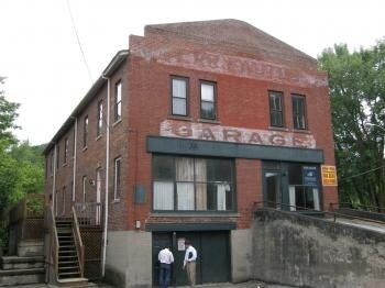


Property Detail
67 E State St
405-126-10969
0.09 AC & 4 APT BLDG
Apartment
WASHINGTON
B and X Area of moderate flood hazard, usually the area between the limits of the 100-year and 500-year floods.
Vermont
2024
0.09 AC
2024
Vermont North Area
954800
Other Market Areas
3,221 SF
Barre, VT
NEARBY LISTINGS FOR SALE OR LEASE
DEMOGRAPHICS near 67 E State St
1 mile
3 mile
5 mile
2025 Total Population
6,262
10,664
17,076
2030 Population
6,233
10,646
17,065
Pop Growth 2025-2030
(0.46%)
(0.17%)
(0.06%)
Average Age
44
44
44
2025 Total Households
3,089
4,977
7,782
HH Growth 2025-2030
(0.42%)
(0.16%)
(0.06%)
Median Household Inc
$82,423
$90,025
$87,537
Avg Household Size
1.90
2.00
2.10
2025 Avg HH Vehicles
1.00
2.00
2.00
Median Home Value
$372,222
$364,082
$348,025
Median Year Built
1952
1963
1967
Nearby Places
Map Layers
Map Styles
 Street
 Aerial
Layers
 Traffic
 Biking
Places
Listings with unknown addresses are not visible on the map
- Restaurants
- Banks
- Shops
- Fitness
- Groceries
PUBLIC TRANSPORTATION
COMMUTER RAIL
Drive
Walk
Distance
5 min
2.1 mi
AIRPORT
Patrick Leahy Burlington International
Drive
Walk
Distance
Patrick Leahy Burlington International
55 min
37.6 mi
SALE & LEASE HISTORY
LISTING DATE
SALE/LEASE

Sep 25, 2016
For Lease
Dec 14, 2016
For Lease
Nearby Properties
Address
Land Use
TOTAL SIZE
Lot Size
Zoning
Address
Land Use
TOTAL SIZE
Lot Size
Zoning
240.06 AC
Address
Land Use
TOTAL SIZE
Lot Size
Zoning
68,909 SF
23.27 AC
Address
Land Use
TOTAL SIZE
Lot Size
Zoning
78,724 SF
2.90 AC
Address
Land Use
TOTAL SIZE
Lot Size
Zoning
Address
Land Use
TOTAL SIZE
Lot Size
Zoning
130,942 SF
Address
Land Use
TOTAL SIZE
Lot Size
Zoning
5,353 SF
Address
Land Use
TOTAL SIZE
Lot Size
Zoning
55.21 AC
Address
Land Use
TOTAL SIZE
Lot Size
Zoning
84,698 SF
2.81 AC
Address
Land Use
TOTAL SIZE
Lot Size
Zoning
62,700 SF
5.41 AC
Address
Land Use
TOTAL SIZE
Lot Size
Zoning
241.56 AC
Address
Land Use
TOTAL SIZE
Lot Size
Zoning
96.42 AC
Address
Land Use
TOTAL SIZE
Lot Size
Zoning
71,718 SF
1.22 AC
Address
Land Use
TOTAL SIZE
Lot Size
Zoning
Address
Land Use
TOTAL SIZE
Lot Size
Zoning
130,941 SF
Address
Land Use
TOTAL SIZE
Lot Size
Zoning
13,260 SF
8.15 AC
Address
Land Use
TOTAL SIZE
Lot Size
Zoning
89,847 SF
20.67 AC
Address
Land Use
TOTAL SIZE
Lot Size
Zoning
50,996 SF
1.60 AC
Address
Land Use
TOTAL SIZE
Lot Size
Zoning
38,091 SF
4.57 AC
Address
Land Use
TOTAL SIZE
Lot Size
Zoning
0.93 AC
Address
Land Use
TOTAL SIZE
Lot Size
Zoning
Address
Land Use
TOTAL SIZE
Lot Size
Zoning
28,902 SF
2.10 AC
Address
Land Use
TOTAL SIZE
Lot Size
Zoning
3.04 AC
Address
Land Use
TOTAL SIZE
Lot Size
Zoning
60,804 SF
3.45 AC
Address
Land Use
TOTAL SIZE
Lot Size
Zoning
37,419 SF
1.60 AC
Address
Land Use
TOTAL SIZE
Lot Size
Zoning
6.72 AC
Address
Land Use
TOTAL SIZE
Lot Size
Zoning
13,576 SF
0.05 AC
Address
Land Use
TOTAL SIZE
Lot Size
Zoning
10.85 AC
Address
Land Use
TOTAL SIZE
Lot Size
Zoning
28,596 SF
5.53 AC
Address
Land Use
TOTAL SIZE
Lot Size
Zoning
12.50 AC
Address
Land Use
TOTAL SIZE
Lot Size
Zoning
39,325 SF
5.70 AC
The World's #1 Commercial Real Estate Marketplace
Connect with us
© 2026 CoStar Group
The information above has been obtained from sources believed reliable. While we do not doubt its accuracy we have not verified it and make no guarantee, warranty or representation about it. It is your responsibility to independently confirm its accuracy and completeness. Any projections, opinions, assumptions, or estimates used are for example only and do not represent the current or future performance of the property. The value of this transaction to you depends on tax and other factors which should be evaluated by your tax, financial, and legal advisors. You and your advisors should conduct a careful, independent investigation of the property to determine to your satisfaction the suitability of the property for your needs.