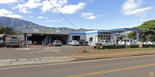
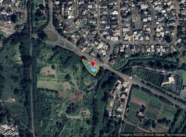
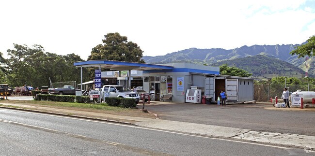
Property Record
67 Farrington Hwy, Waialua, HI 96791
NEARBY LISTINGS FOR SALE OR LEASE
Property Detail
67 Farrington Hwy
1-6-7-002-011-0000
LOT 1-N LCAPP 1140 MAP 2 .392 AC
Commercialnec
Honolulu
AE
Hawaii
15003C0105H
1-n
2024
0.39 AC
2025
North Shore
009905
Hawaii
2,780 SF
Urban Honolulu, HI
DEMOGRAPHICS near 67 Farrington Hwy
1 Mile
3 Mile
5 Mile
2024 Total Population
3,433
7,875
8,389
2029 Population
3,241
7,340
7,814
Pop Growth 2024-2029
(5.59%)
(6.79%)
(6.85%)
Average Age
41
40
41
2024 Total Households
946
2,490
2,652
HH Growth 2024-2029
(6.77%)
(7.91%)
(8.03%)
Median Household Inc
$81,617
$85,427
$84,987
Avg Household Size
3.30
3.00
3.00
2024 Avg HH Vehicles
2.00
2.00
2.00
Median Home Value
$763,071
$810,914
$821,352
Median Year Built
1968
1972
1972
Nearby Places
Map Layers
Map Styles
 Street
 Aerial
- Restaurants
- Banks
- Shops
- Fitness
- Groceries
PUBLIC TRANSPORTATION
AIRPORT
Daniel K Inouye International
DRIVE
WALK
Distance
Daniel K Inouye International
39 min
24.9 mi
Nearby Properties
Address
Land Use
TOTAL SIZE
Lot Size
Zoning
Address
Land Use
TOTAL SIZE
Lot Size
Zoning
1,328.04 AC
AG-1
Address
Land Use
TOTAL SIZE
Lot Size
Zoning
1.22 AC
AG-2
Address
Land Use
TOTAL SIZE
Lot Size
Zoning
4.81 AC
I-3
Address
Land Use
TOTAL SIZE
Lot Size
Zoning
3.96 AC
I-3
Address
Land Use
TOTAL SIZE
Lot Size
Zoning
25,278 SF
3.36 AC
B-2
Address
Land Use
TOTAL SIZE
Lot Size
Zoning
2.83 AC
I-3
Address
Land Use
TOTAL SIZE
Lot Size
Zoning
31,371 SF
2.17 AC
I-1
Address
Land Use
TOTAL SIZE
Lot Size
Zoning
434.19 AC
AG-1
Address
Land Use
TOTAL SIZE
Lot Size
Zoning
19,379 SF
1.18 AC
B-1
Address
Land Use
TOTAL SIZE
Lot Size
Zoning
434.19 AC
AG-1
Address
Land Use
TOTAL SIZE
Lot Size
Zoning
4,788 SF
1.10 AC
B-2
Address
Land Use
TOTAL SIZE
Lot Size
Zoning
32,647 SF
0.82 AC
B-1
Address
Land Use
TOTAL SIZE
Lot Size
Zoning
3,874 SF
0.77 AC
B-1
Address
Land Use
TOTAL SIZE
Lot Size
Zoning
8,513 SF
0.68 AC
B-1
Address
Land Use
TOTAL SIZE
Lot Size
Zoning
3,094 SF
0.96 AC
B-1
Address
Land Use
TOTAL SIZE
Lot Size
Zoning
4,719 SF
0.75 AC
B-1
Address
Land Use
TOTAL SIZE
Lot Size
Zoning
11,138 SF
0.67 AC
B-1
Address
Land Use
TOTAL SIZE
Lot Size
Zoning
3,126 SF
0.72 AC
B-1
Address
Land Use
TOTAL SIZE
Lot Size
Zoning
7,626 SF
3.06 AC
R-5
Address
Land Use
TOTAL SIZE
Lot Size
Zoning
5,500 SF
0.49 AC
B-1
Address
Land Use
TOTAL SIZE
Lot Size
Zoning
42.73 AC
AG-1
Address
Land Use
TOTAL SIZE
Lot Size
Zoning
2,680 SF
2.20 AC
R-5
Address
Land Use
TOTAL SIZE
Lot Size
Zoning
7,642 SF
0.54 AC
B-1
Address
Land Use
TOTAL SIZE
Lot Size
Zoning
13,087 SF
0.46 AC
B-1
Address
Land Use
TOTAL SIZE
Lot Size
Zoning
6,790 SF
0.44 AC
B-1
Address
Land Use
TOTAL SIZE
Lot Size
Zoning
102.70 AC
AG-2
Address
Land Use
TOTAL SIZE
Lot Size
Zoning
5,319 SF
0.47 AC
B-1
Address
Land Use
TOTAL SIZE
Lot Size
Zoning
1,913.77 AC
AG-1
Address
Land Use
TOTAL SIZE
Lot Size
Zoning
3,330 SF
0.52 AC
B-1
The World's #1 Commercial Real Estate Marketplace
Connect with us
© 2025 CoStar Group
The information above has been obtained from sources believed reliable. While we do not doubt its accuracy we have not verified it and make no guarantee, warranty or representation about it. It is your responsibility to independently confirm its accuracy and completeness. Any projections, opinions, assumptions, or estimates used are for example only and do not represent the current or future performance of the property. The value of this transaction to you depends on tax and other factors which should be evaluated by your tax, financial, and legal advisors. You and your advisors should conduct a careful, independent investigation of the property to determine to your satisfaction the suitability of the property for your needs.