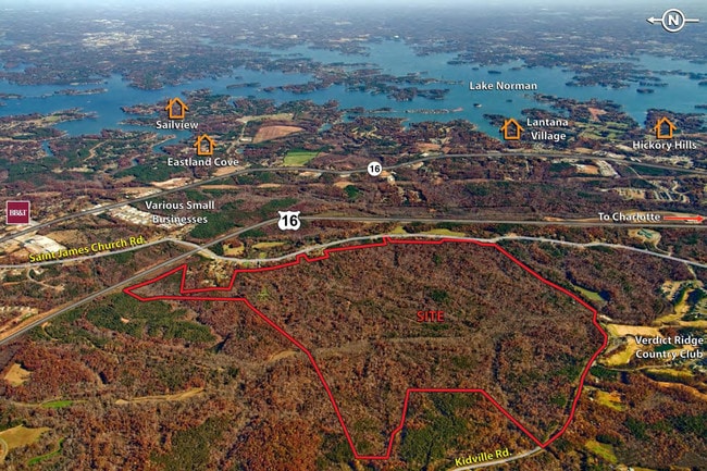
Property Record
67 Kidville Rd, Lincolnton, NC 28092
NEARBY LISTINGS FOR SALE OR LEASE
Property Detail
67 Kidville Rd
Charlotte-Concord-Gastonia, NC-SC
PROCTOR LAND HWY 16
53910
Lincoln
Residentialacreage
North Carolina
2025
601.08 AC
2025
Lincoln County
071101
Charlotte
DEMOGRAPHICS near 67 Kidville Rd
1 Mile
3 Mile
5 Mile
2024 Total Population
305
16,542
39,913
2029 Population
366
19,601
46,686
Pop Growth 2024-2029
+ 20.00%
+ 18.49%
+ 16.97%
Average Age
40
42
43
2024 Total Households
120
6,422
15,764
HH Growth 2024-2029
+ 20.00%
+ 18.72%
+ 17.13%
Median Household Inc
$72,793
$100,810
$98,325
Avg Household Size
2.50
2.60
2.50
2024 Avg HH Vehicles
2.00
2.00
2.00
Median Home Value
$291,303
$403,969
$422,283
Median Year Built
2004
2001
2001
Nearby Places
Map Layers
Map Styles
 Street
 Aerial
- Restaurants
- Banks
- Shops
- Fitness
- Groceries
PUBLIC TRANSPORTATION
AIRPORT
Charlotte/Douglas International
DRIVE
WALK
Distance
Charlotte/Douglas International
44 min
25.1 mi
Concord-Padgett Regional
DRIVE
WALK
Distance
Concord-Padgett Regional
43 min
30.4 mi
Freight Ports
North Charleston Terminal
DRIVE
WALK
Distance
North Charleston Terminal
255 min
220.9 mi
SALE & LEASE HISTORY
LISTING DATE
SALE/LEASE

Sep 24, 2016
For Sale
Nearby Properties
Address
Land Use
TOTAL SIZE
Lot Size
Zoning
Address
Land Use
TOTAL SIZE
Lot Size
Zoning
897,320 SF
109.51 AC
I-G
Address
Land Use
TOTAL SIZE
Lot Size
Zoning
23,112 SF
11.70 AC
ELDD PD-MU
Address
Land Use
TOTAL SIZE
Lot Size
Zoning
56,780 SF
30.55 AC
B-G
Address
Land Use
TOTAL SIZE
Lot Size
Zoning
201,670 SF
20.06 AC
I-G
Address
Land Use
TOTAL SIZE
Lot Size
Zoning
52,732 SF
17.01 AC
ELDD R-SF
Address
Land Use
TOTAL SIZE
Lot Size
Zoning
91,753 SF
19.94 AC
R-T
Address
Land Use
TOTAL SIZE
Lot Size
Zoning
6,264 SF
24.64 AC
ELDD B-G
Address
Land Use
TOTAL SIZE
Lot Size
Zoning
66,136 SF
18.10 AC
ELDD B-N &
Address
Land Use
TOTAL SIZE
Lot Size
Zoning
9,827 SF
13.35 AC
ELDD R-SF
Address
Land Use
TOTAL SIZE
Lot Size
Zoning
7,800 SF
4.49 AC
ELDD B-G C
Address
Land Use
TOTAL SIZE
Lot Size
Zoning
115,200 SF
20.31 AC
I-G
Address
Land Use
TOTAL SIZE
Lot Size
Zoning
251,009 SF
20.46 AC
ELDD I-G
Address
Land Use
TOTAL SIZE
Lot Size
Zoning
42,185 SF
5.26 AC
B-G
Address
Land Use
TOTAL SIZE
Lot Size
Zoning
12,948 SF
28.37 AC
R-SF
Address
Land Use
TOTAL SIZE
Lot Size
Zoning
32,163 SF
48.72 AC
ELDD R-T
Address
Land Use
TOTAL SIZE
Lot Size
Zoning
120,500 SF
12.50 AC
ELDD I-G
Address
Land Use
TOTAL SIZE
Lot Size
Zoning
17,443 SF
19.66 AC
B-G
Address
Land Use
TOTAL SIZE
Lot Size
Zoning
81,228 SF
26.89 AC
ELDD B-N C
Address
Land Use
TOTAL SIZE
Lot Size
Zoning
87,700 SF
7.53 AC
I-G
Address
Land Use
TOTAL SIZE
Lot Size
Zoning
17,978 SF
39.55 AC
R-T
Address
Land Use
TOTAL SIZE
Lot Size
Zoning
8,100 SF
275.67 AC
PD-R CU
Address
Land Use
TOTAL SIZE
Lot Size
Zoning
20,923 SF
2.83 AC
R-S CU
Address
Land Use
TOTAL SIZE
Lot Size
Zoning
7,059 SF
5.32 AC
R-SF
Address
Land Use
TOTAL SIZE
Lot Size
Zoning
44,606 SF
4.49 AC
ELDD PD-I
Address
Land Use
TOTAL SIZE
Lot Size
Zoning
45,326 SF
4.45 AC
ELDD B-G
Address
Land Use
TOTAL SIZE
Lot Size
Zoning
12,000 SF
7.87 AC
ELDD B-G C
Address
Land Use
TOTAL SIZE
Lot Size
Zoning
14,854 SF
16.71 AC
ELDD R-S &
Address
Land Use
TOTAL SIZE
Lot Size
Zoning
1,796 SF
487.06 AC
R-T
Address
Land Use
TOTAL SIZE
Lot Size
Zoning
12,500 SF
2.53 AC
ELDD B-G
The World's #1 Commercial Real Estate Marketplace
Connect with us
© 2025 CoStar Group
The information above has been obtained from sources believed reliable. While we do not doubt its accuracy we have not verified it and make no guarantee, warranty or representation about it. It is your responsibility to independently confirm its accuracy and completeness. Any projections, opinions, assumptions, or estimates used are for example only and do not represent the current or future performance of the property. The value of this transaction to you depends on tax and other factors which should be evaluated by your tax, financial, and legal advisors. You and your advisors should conduct a careful, independent investigation of the property to determine to your satisfaction the suitability of the property for your needs.