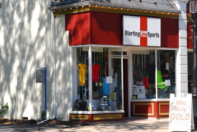
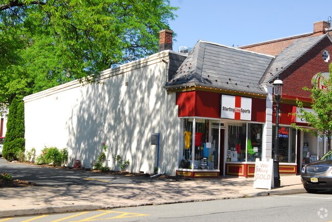
Property Record
67 Main St, Madison, NJ 07940

Property Detail
67 Main St
17-02702-0000-00002
Morris
Commercialnec
New Jersey
CBD1
2
B and X Area of moderate flood hazard, usually the area between the limits of the 100-year and 500-year floods.
0.14 AC
2024
Morristown Region
2025
Northern New Jersey
043000
Newark, NJ
3,536 SF
NEARBY LISTINGS FOR SALE OR LEASE
DEMOGRAPHICS near 67 Main St
1 mile
3 mile
5 mile
2025 Total Population
13,864
56,162
161,682
2030 Population
14,101
57,862
168,129
Pop Growth 2025-2030
+ 1.71%
+ 3.03%
+ 3.99%
Average Age
39
41
41
2025 Total Households
4,636
19,906
58,806
HH Growth 2025-2030
+ 1.68%
+ 3.23%
+ 4.03%
Median Household Inc
$169,595
$184,326
$174,876
Avg Household Size
2.60
2.60
2.60
2025 Avg HH Vehicles
2.00
2.00
2.00
Median Home Value
$901,973
$866,149
$839,008
Median Year Built
1956
1965
1964
Nearby Places
Map Layers
Map Styles
 Street
 Aerial
Transit
 Traffic
 Biking
Places
Listings with unknown addresses are not visible on the map
- Restaurants
- Banks
- Shops
- Fitness
- Groceries
PUBLIC TRANSPORTATION
COMMUTER RAIL
Madison (Morris & Essex Morristown Line - NJ Transit Commuter Rail (NJ Transit))
Drive
Walk
Distance
Madison (Morris & Essex Morristown Line - NJ Transit Commuter Rail (NJ Transit))
0 min
2 min
0.1 mi
Chatham (Morris & Essex Morristown Line - NJ Transit Commuter Rail (NJ Transit))
Drive
Walk
Distance
Chatham (Morris & Essex Morristown Line - NJ Transit Commuter Rail (NJ Transit))
5 min
2.1 mi
AIRPORT
Newark Liberty International
Drive
Walk
Distance
Newark Liberty International
25 min
16.8 mi
LaGuardia
Drive
Walk
Distance
LaGuardia
59 min
36.0 mi
Freight Ports
Maher Terminal
Drive
Walk
Distance
Maher Terminal
27 min
17.2 mi
Nearby Properties
Address
Land Use
TOTAL SIZE
Lot Size
Zoning
Address
Land Use
TOTAL SIZE
Lot Size
Zoning
46.18 AC
Address
Land Use
TOTAL SIZE
Lot Size
Zoning
66,201 SF
168.40 AC
R-3
Address
Land Use
TOTAL SIZE
Lot Size
Zoning
1,968 SF
88.85 AC
PROD
Address
Land Use
TOTAL SIZE
Lot Size
Zoning
64.30 AC
MF-4
Address
Land Use
TOTAL SIZE
Lot Size
Zoning
64.80 AC
C-4
Address
Land Use
TOTAL SIZE
Lot Size
Zoning
72,698 SF
133.64 AC
U
Address
Land Use
TOTAL SIZE
Lot Size
Zoning
4,595 SF
4.57 AC
M-3
Address
Land Use
TOTAL SIZE
Lot Size
Zoning
9.80 AC
Address
Land Use
TOTAL SIZE
Lot Size
Zoning
31.03 AC
R-L
Address
Land Use
TOTAL SIZE
Lot Size
Zoning
50.01 AC
PCDO
Address
Land Use
TOTAL SIZE
Lot Size
Zoning
19.05 AC
R-2
Address
Land Use
TOTAL SIZE
Lot Size
Zoning
Address
Land Use
TOTAL SIZE
Lot Size
Zoning
270,000 SF
15.32 AC
OR
Address
Land Use
TOTAL SIZE
Lot Size
Zoning
10.94 AC
Address
Land Use
TOTAL SIZE
Lot Size
Zoning
41.19 AC
MF-C
Address
Land Use
TOTAL SIZE
Lot Size
Zoning
43.60 AC
C-4
Address
Land Use
TOTAL SIZE
Lot Size
Zoning
59,369 SF
86.79 AC
R-44
Address
Land Use
TOTAL SIZE
Lot Size
Zoning
296,578 SF
15 AC
Address
Land Use
TOTAL SIZE
Lot Size
Zoning
Address
Land Use
TOTAL SIZE
Lot Size
Zoning
10.42 AC
Address
Land Use
TOTAL SIZE
Lot Size
Zoning
27.20 AC
PODS
Address
Land Use
TOTAL SIZE
Lot Size
Zoning
304,213 SF
21.73 AC
PODS
Address
Land Use
TOTAL SIZE
Lot Size
Zoning
6.64 AC
Address
Land Use
TOTAL SIZE
Lot Size
Zoning
20 AC
PCDO
Address
Land Use
TOTAL SIZE
Lot Size
Zoning
200,360 SF
16.20 AC
OL-5
Address
Land Use
TOTAL SIZE
Lot Size
Zoning
18.29 AC
C-1
Address
Land Use
TOTAL SIZE
Lot Size
Zoning
252,828 SF
44.53 AC
C-1
Address
Land Use
TOTAL SIZE
Lot Size
Zoning
40.90 AC
MF-4
Address
Land Use
TOTAL SIZE
Lot Size
Zoning
146,538 SF
20 AC
PCDO
Address
Land Use
TOTAL SIZE
Lot Size
Zoning
5.35 AC
MF-6
The World's #1 Commercial Real Estate Marketplace
Connect with us
© 2026 CoStar Group
The information above has been obtained from sources believed reliable. While we do not doubt its accuracy we have not verified it and make no guarantee, warranty or representation about it. It is your responsibility to independently confirm its accuracy and completeness. Any projections, opinions, assumptions, or estimates used are for example only and do not represent the current or future performance of the property. The value of this transaction to you depends on tax and other factors which should be evaluated by your tax, financial, and legal advisors. You and your advisors should conduct a careful, independent investigation of the property to determine to your satisfaction the suitability of the property for your needs.