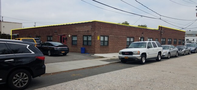
Property Record
67 N Prospect Ave, Lynbrook, NY 11563
NEARBY LISTINGS FOR SALE OR LEASE
-
-
-
-
-
-
-
-
-
-
-
No Photo
-
-
-
View all Lynbrook listings for sale on LoopNet.com
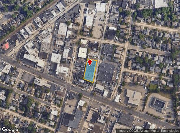
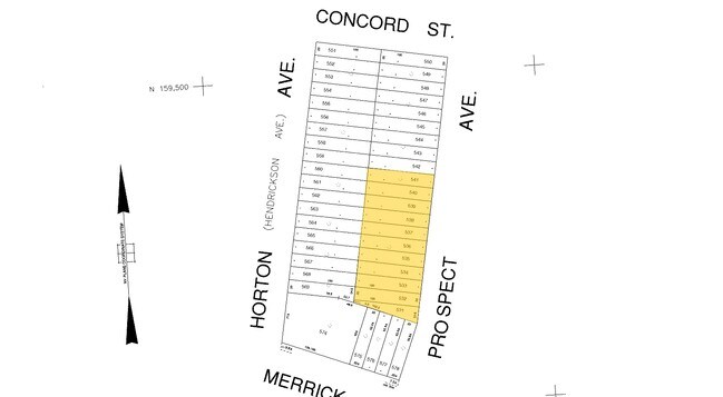
Property Detail
67 N Prospect Ave
Nassau County-Suffolk County, NY
Map Of Lynbroon Manor
2025-37-285-00-0531-0
531-541
Lightindustrial
Nassau
X
New York
36059C0216G
531-5
2025
0.49 AC
2025
Southern Nassau
411800
Long Island (New York)
14,205 SF
DEMOGRAPHICS near 67 N Prospect Ave
1 Mile
3 Mile
5 Mile
2024 Total Population
30,585
242,186
632,462
2029 Population
29,778
234,611
606,893
Pop Growth 2024-2029
(2.64%)
(3.13%)
(4.04%)
Average Age
41
41
41
2024 Total Households
10,324
77,698
199,273
HH Growth 2024-2029
(2.85%)
(3.25%)
(4.23%)
Median Household Inc
$127,810
$121,532
$109,247
Avg Household Size
2.90
3.00
3.10
2024 Avg HH Vehicles
2.00
2.00
2.00
Median Home Value
$620,171
$649,453
$641,850
Median Year Built
1948
1952
1951
Nearby Places
- Restaurants
- Banks
- Shops
- Fitness
- Groceries
PUBLIC TRANSPORTATION
TRANSIT/SUBWAY
Westwood Station (West Hempstead Branch - Long Island Rail Road)
DRIVE
WALK
Distance
Westwood Station (West Hempstead Branch - Long Island Rail Road)
3 min
12 min
0.6 mi
Lynbrook Station (Babylon Branch - Long Island Rail Road, Long Beach Branch - Long Island Rail Road)
DRIVE
WALK
Distance
Lynbrook Station (Babylon Branch - Long Island Rail Road, Long Beach Branch - Long Island Rail Road)
2 min
17 min
0.9 mi
COMMUTER RAIL
Westwood Station (West Hempstead Branch - Long Island Rail Road)
DRIVE
WALK
Distance
Westwood Station (West Hempstead Branch - Long Island Rail Road)
3 min
12 min
0.6 mi
Lynbrook Station (Babylon Branch - Long Island Rail Road, Long Beach Branch - Long Island Rail Road)
DRIVE
WALK
Distance
Lynbrook Station (Babylon Branch - Long Island Rail Road, Long Beach Branch - Long Island Rail Road)
2 min
17 min
0.9 mi
AIRPORT
John F Kennedy International
DRIVE
WALK
Distance
John F Kennedy International
14 min
8.0 mi
LaGuardia
DRIVE
WALK
Distance
LaGuardia
24 min
15.0 mi
Newark Liberty International
DRIVE
WALK
Distance
Newark Liberty International
51 min
34.8 mi
Freight Ports
NY - Red Hook Container Terminal
DRIVE
WALK
Distance
NY - Red Hook Container Terminal
35 min
19.5 mi
SALE & LEASE HISTORY
LISTING DATE
SALE/LEASE

Sep 30, 2016
For Lease
Sep 21, 2017
For Lease
Sep 19, 2017
For Sale
Nov 23, 2016
For Sale
May 20, 2020
For Sale
Mar 02, 2019
For Lease
Nearby Properties
Address
Land Use
TOTAL SIZE
Lot Size
Zoning
Address
Land Use
TOTAL SIZE
Lot Size
Zoning
129,378 SF
4.86 AC
R2A
Address
Land Use
TOTAL SIZE
Lot Size
Zoning
64,618 SF
8.04 AC
Address
Land Use
TOTAL SIZE
Lot Size
Zoning
5,296 SF
37.42 AC
PARK
Address
Land Use
TOTAL SIZE
Lot Size
Zoning
213,338 SF
2.91 AC
R3X
Address
Land Use
TOTAL SIZE
Lot Size
Zoning
97,190 SF
1.75 AC
R3X
Address
Land Use
TOTAL SIZE
Lot Size
Zoning
78,380 SF
0.85 AC
R3-2
Address
Land Use
TOTAL SIZE
Lot Size
Zoning
260,000 SF
4.14 AC
R2
Address
Land Use
TOTAL SIZE
Lot Size
Zoning
85,330 SF
2.91 AC
R3-2
Address
Land Use
TOTAL SIZE
Lot Size
Zoning
73,300 SF
1.93 AC
R2
Address
Land Use
TOTAL SIZE
Lot Size
Zoning
41,712 SF
0.51 AC
R2A
Address
Land Use
TOTAL SIZE
Lot Size
Zoning
2,634,357 SF
57.63 AC
Address
Land Use
TOTAL SIZE
Lot Size
Zoning
10,405 SF
4.97 AC
R3-1
Address
Land Use
TOTAL SIZE
Lot Size
Zoning
13,334 SF
2.11 AC
R2
Address
Land Use
TOTAL SIZE
Lot Size
Zoning
33,912 SF
2.37 AC
R3X
Address
Land Use
TOTAL SIZE
Lot Size
Zoning
3.48 AC
R3-2
Address
Land Use
TOTAL SIZE
Lot Size
Zoning
202.54 AC
Address
Land Use
TOTAL SIZE
Lot Size
Zoning
10,000 SF
0.46 AC
R3-2
Address
Land Use
TOTAL SIZE
Lot Size
Zoning
14,966 SF
0.89 AC
R2
Address
Land Use
TOTAL SIZE
Lot Size
Zoning
8,000 SF
0.51 AC
R3X
Address
Land Use
TOTAL SIZE
Lot Size
Zoning
4,300 SF
0.29 AC
R3-2
Address
Land Use
TOTAL SIZE
Lot Size
Zoning
9,360 SF
0.55 AC
R3X
Address
Land Use
TOTAL SIZE
Lot Size
Zoning
9,900 SF
0.23 AC
R3-2
Address
Land Use
TOTAL SIZE
Lot Size
Zoning
88.30 AC
Address
Land Use
TOTAL SIZE
Lot Size
Zoning
7,176 SF
0.96 AC
R3X
Address
Land Use
TOTAL SIZE
Lot Size
Zoning
10,250 SF
0.70 AC
R3-2
Address
Land Use
TOTAL SIZE
Lot Size
Zoning
23,350 SF
1.07 AC
R3-2
Address
Land Use
TOTAL SIZE
Lot Size
Zoning
24,381 SF
1.05 AC
R3-2
Address
Land Use
TOTAL SIZE
Lot Size
Zoning
30,700 SF
88.36 AC
Address
Land Use
TOTAL SIZE
Lot Size
Zoning
0.70 AC
R6B
Address
Land Use
TOTAL SIZE
Lot Size
Zoning
11,000 SF
0.30 AC
R3X
The World's #1 Commercial Real Estate Marketplace
Connect with us
© 2025 CoStar Group
The information above has been obtained from sources believed reliable. While we do not doubt its accuracy we have not verified it and make no guarantee, warranty or representation about it. It is your responsibility to independently confirm its accuracy and completeness. Any projections, opinions, assumptions, or estimates used are for example only and do not represent the current or future performance of the property. The value of this transaction to you depends on tax and other factors which should be evaluated by your tax, financial, and legal advisors. You and your advisors should conduct a careful, independent investigation of the property to determine to your satisfaction the suitability of the property for your needs.