Property Record
67 Route 27, Brentwood, NH 03833

NEARBY LISTINGS FOR SALE OR LEASE
Property Detail
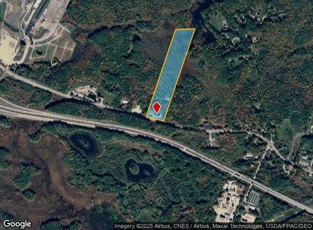
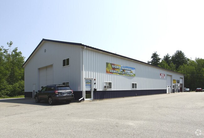
67 Route 27
Timberlandforesttreesagricultural
Rockingham
A
New Hampshire
33015C0220F
19.15 AC
2024
Rockingham
2024
Boston
060000
Boston-Cambridge-Newton, MA-NH
9,120 SF
BREN-000204-000003
DEMOGRAPHICS near 67 Route 27
1 Mile
3 Mile
5 Mile
2024 Total Population
243
5,757
30,784
2029 Population
247
5,926
31,962
Pop Growth 2024-2029
+ 1.65%
+ 2.94%
+ 3.83%
Average Age
43
43
44
2024 Total Households
82
2,086
12,347
HH Growth 2024-2029
+ 2.44%
+ 2.92%
+ 3.82%
Median Household Inc
$111,250
$122,531
$105,387
Avg Household Size
2.60
2.60
2.40
2024 Avg HH Vehicles
2.00
2.00
2.00
Median Home Value
$453,124
$466,554
$446,355
Median Year Built
1981
1987
1985
Nearby Places
Map Layers
Map Styles
 Street
 Aerial
- Restaurants
- Banks
- Shops
- Fitness
- Groceries
PUBLIC TRANSPORTATION
COMMUTER RAIL
Exeter (Downeaster - Amtrak)
DRIVE
WALK
Distance
Exeter (Downeaster - Amtrak)
9 min
4.3 mi
AIRPORT
Portsmouth International at Pease
DRIVE
WALK
Distance
Portsmouth International at Pease
32 min
17.0 mi
Manchester Boston Regional
DRIVE
WALK
Distance
Manchester Boston Regional
42 min
29.4 mi
Freight Ports
Port of Boston
DRIVE
WALK
Distance
Port of Boston
80 min
58.8 mi
Nearby Properties
Address
Land Use
TOTAL SIZE
Lot Size
Zoning
Address
Land Use
TOTAL SIZE
Lot Size
Zoning
331,064 SF
120.31 AC
RU
Address
Land Use
TOTAL SIZE
Lot Size
Zoning
258,254 SF
80.96 AC
MF/P
Address
Land Use
TOTAL SIZE
Lot Size
Zoning
84,479 SF
18.74 AC
CT-1
Address
Land Use
TOTAL SIZE
Lot Size
Zoning
204,175 SF
57.27 AC
IC
Address
Land Use
TOTAL SIZE
Lot Size
Zoning
40,693 SF
5 AC
IC
Address
Land Use
TOTAL SIZE
Lot Size
Zoning
135,037 SF
14.81 AC
IC
Address
Land Use
TOTAL SIZE
Lot Size
Zoning
106,476 SF
20.35 AC
CT-1
Address
Land Use
TOTAL SIZE
Lot Size
Zoning
52,375 SF
11.70 AC
CT-1
Address
Land Use
TOTAL SIZE
Lot Size
Zoning
84,326 SF
9.47 AC
I
Address
Land Use
TOTAL SIZE
Lot Size
Zoning
129,062 SF
40.37 AC
C/I
Address
Land Use
TOTAL SIZE
Lot Size
Zoning
14.46 AC
C-3
Address
Land Use
TOTAL SIZE
Lot Size
Zoning
39,000 SF
45.34 AC
C/I
Address
Land Use
TOTAL SIZE
Lot Size
Zoning
78,461 SF
8.50 AC
I
Address
Land Use
TOTAL SIZE
Lot Size
Zoning
31,688 SF
6.73 AC
C-3
Address
Land Use
TOTAL SIZE
Lot Size
Zoning
77,724 SF
3.90 AC
IC
Address
Land Use
TOTAL SIZE
Lot Size
Zoning
13,624 SF
6.49 AC
IC
Address
Land Use
TOTAL SIZE
Lot Size
Zoning
41,928 SF
5.01 AC
CT-1
Address
Land Use
TOTAL SIZE
Lot Size
Zoning
4,248 SF
241.80 AC
IC
Address
Land Use
TOTAL SIZE
Lot Size
Zoning
8,200 SF
72.89 AC
IC
Address
Land Use
TOTAL SIZE
Lot Size
Zoning
330 AC
C/I
Address
Land Use
TOTAL SIZE
Lot Size
Zoning
44,305 SF
4.65 AC
C/I
Address
Land Use
TOTAL SIZE
Lot Size
Zoning
1,323 SF
93.62 AC
RES
Address
Land Use
TOTAL SIZE
Lot Size
Zoning
19,594 SF
5.27 AC
C-3
Address
Land Use
TOTAL SIZE
Lot Size
Zoning
13,888 SF
1.27 AC
IC
Address
Land Use
TOTAL SIZE
Lot Size
Zoning
46,266 SF
3.98 AC
I
Address
Land Use
TOTAL SIZE
Lot Size
Zoning
23,320 SF
8.46 AC
HC
Address
Land Use
TOTAL SIZE
Lot Size
Zoning
58,784 SF
8.37 AC
CP
Address
Land Use
TOTAL SIZE
Lot Size
Zoning
21,730 SF
4.80 AC
IC
Address
Land Use
TOTAL SIZE
Lot Size
Zoning
22,400 SF
9.30 AC
CT-1
Address
Land Use
TOTAL SIZE
Lot Size
Zoning
19,246 SF
5.87 AC
C/I
The World's #1 Commercial Real Estate Marketplace
Connect with us
© 2025 CoStar Group
The information above has been obtained from sources believed reliable. While we do not doubt its accuracy we have not verified it and make no guarantee, warranty or representation about it. It is your responsibility to independently confirm its accuracy and completeness. Any projections, opinions, assumptions, or estimates used are for example only and do not represent the current or future performance of the property. The value of this transaction to you depends on tax and other factors which should be evaluated by your tax, financial, and legal advisors. You and your advisors should conduct a careful, independent investigation of the property to determine to your satisfaction the suitability of the property for your needs.