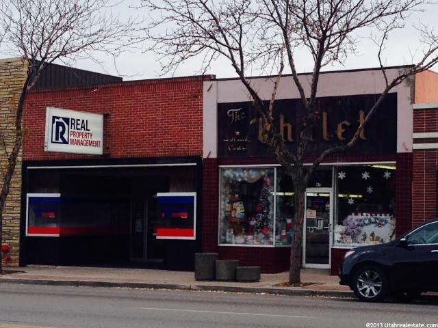
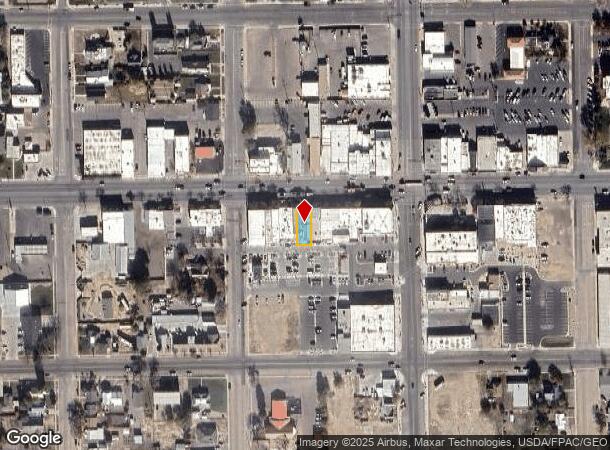
Property Record
67 W Main St, Vernal, UT 84078
NEARBY LISTINGS FOR SALE OR LEASE
Property Detail
67 W Main St
Vernal, UT
Vernal City Plat A
05-026-0007
BEG AT PT 130.3 FT E OF NW COR LOT 2, BLK 11, PLAT A ORIG VERNAL, SURVEY TH S 6 1/6 RDS; E 20 FT; N 6 1/2 RDS W 20 FT TO BEG
Storebuilding
Uintah
X
Utah
49047C0660D
2
2024
0.10 AC
2024
Utah North Area
968403
Other Market Areas
DEMOGRAPHICS near 67 W Main St
1 Mile
3 Mile
5 Mile
2024 Total Population
9,355
22,705
30,687
2029 Population
10,451
25,052
33,781
Pop Growth 2024-2029
+ 11.72%
+ 10.34%
+ 10.08%
Average Age
33
34
34
2024 Total Households
3,582
8,035
10,482
HH Growth 2024-2029
+ 11.28%
+ 9.97%
+ 9.70%
Median Household Inc
$50,448
$56,694
$64,441
Avg Household Size
2.60
2.80
2.90
2024 Avg HH Vehicles
2.00
2.00
2.00
Median Home Value
$177,192
$242,012
$272,727
Median Year Built
1981
1990
1992
Nearby Places
Map Layers
Map Styles
 Street
 Aerial
- Restaurants
- Banks
- Shops
- Fitness
- Groceries
Nearby Properties
Address
Land Use
TOTAL SIZE
Lot Size
Zoning
Address
Land Use
TOTAL SIZE
Lot Size
Zoning
115,697 SF
4.23 AC
Address
Land Use
TOTAL SIZE
Lot Size
Zoning
13.52 AC
Address
Land Use
TOTAL SIZE
Lot Size
Zoning
186,357 SF
10.19 AC
Address
Land Use
TOTAL SIZE
Lot Size
Zoning
8.33 AC
Address
Land Use
TOTAL SIZE
Lot Size
Zoning
7.09 AC
Address
Land Use
TOTAL SIZE
Lot Size
Zoning
10,000 SF
30 AC
Address
Land Use
TOTAL SIZE
Lot Size
Zoning
1.87 AC
Address
Land Use
TOTAL SIZE
Lot Size
Zoning
72,730 SF
1.70 AC
Address
Land Use
TOTAL SIZE
Lot Size
Zoning
5.16 AC
Address
Land Use
TOTAL SIZE
Lot Size
Zoning
Address
Land Use
TOTAL SIZE
Lot Size
Zoning
Address
Land Use
TOTAL SIZE
Lot Size
Zoning
3.07 AC
Address
Land Use
TOTAL SIZE
Lot Size
Zoning
6.66 AC
Address
Land Use
TOTAL SIZE
Lot Size
Zoning
45,183 SF
2 AC
Address
Land Use
TOTAL SIZE
Lot Size
Zoning
7.30 AC
Address
Land Use
TOTAL SIZE
Lot Size
Zoning
2.86 AC
Address
Land Use
TOTAL SIZE
Lot Size
Zoning
Address
Land Use
TOTAL SIZE
Lot Size
Zoning
27,275 SF
3.24 AC
Address
Land Use
TOTAL SIZE
Lot Size
Zoning
34,089 SF
1.06 AC
Address
Land Use
TOTAL SIZE
Lot Size
Zoning
Address
Land Use
TOTAL SIZE
Lot Size
Zoning
42,946 SF
3.94 AC
Address
Land Use
TOTAL SIZE
Lot Size
Zoning
3.15 AC
Address
Land Use
TOTAL SIZE
Lot Size
Zoning
1.40 AC
Address
Land Use
TOTAL SIZE
Lot Size
Zoning
44,235 SF
3.94 AC
Address
Land Use
TOTAL SIZE
Lot Size
Zoning
Address
Land Use
TOTAL SIZE
Lot Size
Zoning
4.47 AC
Address
Land Use
TOTAL SIZE
Lot Size
Zoning
Address
Land Use
TOTAL SIZE
Lot Size
Zoning
Address
Land Use
TOTAL SIZE
Lot Size
Zoning
19.36 AC
Address
Land Use
TOTAL SIZE
Lot Size
Zoning
3.03 AC
The World's #1 Commercial Real Estate Marketplace
Connect with us
© 2025 CoStar Group
The information above has been obtained from sources believed reliable. While we do not doubt its accuracy we have not verified it and make no guarantee, warranty or representation about it. It is your responsibility to independently confirm its accuracy and completeness. Any projections, opinions, assumptions, or estimates used are for example only and do not represent the current or future performance of the property. The value of this transaction to you depends on tax and other factors which should be evaluated by your tax, financial, and legal advisors. You and your advisors should conduct a careful, independent investigation of the property to determine to your satisfaction the suitability of the property for your needs.