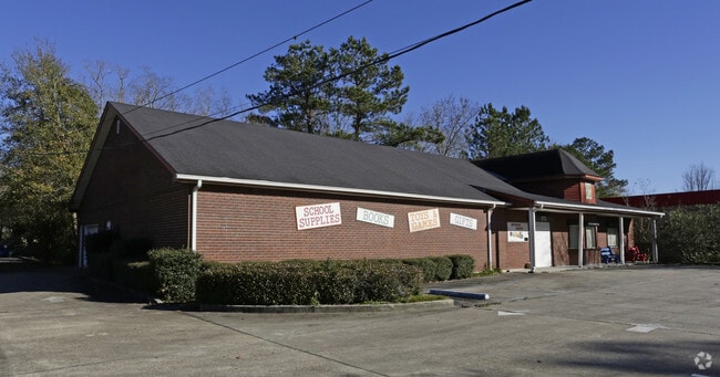
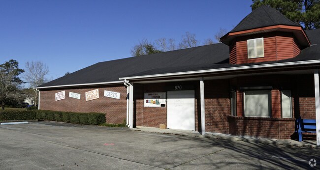
Property Record
670 Brownswitch Rd, Slidell, LA 70458

Property Detail
670 Brownswitch Rd
Slidell-Mandeville-Covington, LA
LOTS 3 4 GALERIA COMMERCIAL PARK PH 1 CB 1149 341 CB 1209 484 INST NO 966056 INST NO 1710052 INST NO 2043838
95988
Saint Tammany
Commercialnec
Louisiana
2025
3
2025
2 AC
040705
Slidell
5,016 SF
New Orleans/Metairie/Kenner
NEARBY LISTINGS FOR SALE OR LEASE
DEMOGRAPHICS near 670 Brownswitch Rd
1 mile
3 mile
5 mile
2025 Total Population
9,027
43,127
79,366
2030 Population
9,265
44,309
81,826
Pop Growth 2025-2030
+ 2.64%
+ 2.74%
+ 3.10%
Average Age
40
41
40
2025 Total Households
3,423
16,301
30,237
HH Growth 2025-2030
+ 2.60%
+ 2.77%
+ 3.16%
Median Household Inc
$70,809
$77,723
$68,546
Avg Household Size
2.60
2.60
2.60
2025 Avg HH Vehicles
2.00
2.00
2.00
Median Home Value
$222,399
$239,857
$228,473
Median Year Built
1984
1986
1988
Nearby Places
Map Layers
Map Styles
 Street
 Aerial
Layers
 Traffic
 Biking
Places
Listings with unknown addresses are not visible on the map
- Restaurants
- Banks
- Shops
- Fitness
- Groceries
PUBLIC TRANSPORTATION
COMMUTER RAIL
Drive
Walk
Distance
7 min
3.7 mi
AIRPORT
Louis Armstrong New Orleans International
Drive
Walk
Distance
Louis Armstrong New Orleans International
59 min
45.5 mi
Freight Ports
Port of New Orleans
Drive
Walk
Distance
Port of New Orleans
52 min
37.8 mi
SALE & LEASE HISTORY
LISTING DATE
SALE/LEASE

Sep 25, 2016
For Lease
Sep 24, 2016
For Sale
Oct 25, 2016
For Lease
Feb 14, 2018
For Lease
Nearby Properties
Address
Land Use
TOTAL SIZE
Lot Size
Zoning
Address
Land Use
TOTAL SIZE
Lot Size
Zoning
858,000 SF
59.39 AC
Address
Land Use
TOTAL SIZE
Lot Size
Zoning
660,450 SF
68.42 AC
Address
Land Use
TOTAL SIZE
Lot Size
Zoning
120,000 SF
6.75 AC
Address
Land Use
TOTAL SIZE
Lot Size
Zoning
104,000 SF
12.89 AC
Address
Land Use
TOTAL SIZE
Lot Size
Zoning
205,496 SF
27.47 AC
Address
Land Use
TOTAL SIZE
Lot Size
Zoning
222,530 SF
40 AC
Address
Land Use
TOTAL SIZE
Lot Size
Zoning
85,000 SF
12.23 AC
Address
Land Use
TOTAL SIZE
Lot Size
Zoning
197,221 SF
1.60 AC
Address
Land Use
TOTAL SIZE
Lot Size
Zoning
157,561 SF
10.06 AC
Address
Land Use
TOTAL SIZE
Lot Size
Zoning
62,506 SF
Address
Land Use
TOTAL SIZE
Lot Size
Zoning
132,961 SF
12.06 AC
Address
Land Use
TOTAL SIZE
Lot Size
Zoning
123,155 SF
15 AC
Address
Land Use
TOTAL SIZE
Lot Size
Zoning
127,681 SF
3 AC
Address
Land Use
TOTAL SIZE
Lot Size
Zoning
59,987 SF
4.29 AC
Address
Land Use
TOTAL SIZE
Lot Size
Zoning
105,633 SF
11 AC
Address
Land Use
TOTAL SIZE
Lot Size
Zoning
104,821 SF
10.09 AC
Address
Land Use
TOTAL SIZE
Lot Size
Zoning
84,000 SF
10.84 AC
Address
Land Use
TOTAL SIZE
Lot Size
Zoning
115,568 SF
0.21 AC
Address
Land Use
TOTAL SIZE
Lot Size
Zoning
118,344 SF
Address
Land Use
TOTAL SIZE
Lot Size
Zoning
53,331 SF
1.75 AC
Address
Land Use
TOTAL SIZE
Lot Size
Zoning
105,300 SF
8.75 AC
Address
Land Use
TOTAL SIZE
Lot Size
Zoning
137,759 SF
1 AC
Address
Land Use
TOTAL SIZE
Lot Size
Zoning
104,702 SF
11.69 AC
Address
Land Use
TOTAL SIZE
Lot Size
Zoning
78,248 SF
4.78 AC
Address
Land Use
TOTAL SIZE
Lot Size
Zoning
144,674 SF
13.10 AC
Address
Land Use
TOTAL SIZE
Lot Size
Zoning
49,091 SF
3.35 AC
Address
Land Use
TOTAL SIZE
Lot Size
Zoning
44,390 SF
1.69 AC
Address
Land Use
TOTAL SIZE
Lot Size
Zoning
116,077 SF
9.14 AC
Address
Land Use
TOTAL SIZE
Lot Size
Zoning
114,806 SF
10.22 AC
Address
Land Use
TOTAL SIZE
Lot Size
Zoning
91,149 SF
4.26 AC
The World's #1 Commercial Real Estate Marketplace
Connect with us
© 2026 CoStar Group
The information above has been obtained from sources believed reliable. While we do not doubt its accuracy we have not verified it and make no guarantee, warranty or representation about it. It is your responsibility to independently confirm its accuracy and completeness. Any projections, opinions, assumptions, or estimates used are for example only and do not represent the current or future performance of the property. The value of this transaction to you depends on tax and other factors which should be evaluated by your tax, financial, and legal advisors. You and your advisors should conduct a careful, independent investigation of the property to determine to your satisfaction the suitability of the property for your needs.