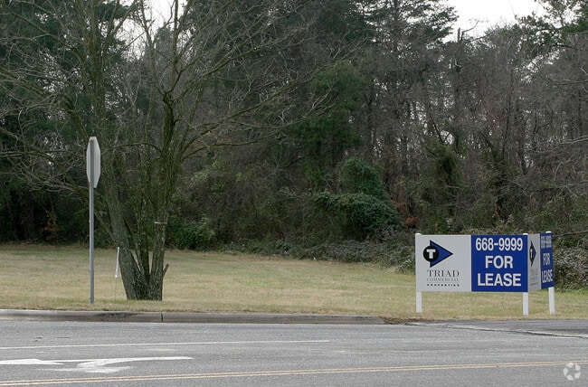
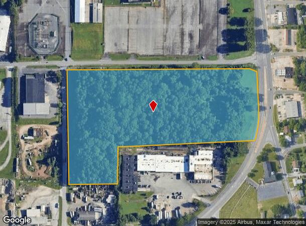
Property Record
670 Cassell St, Winston Salem, NC 27107
NEARBY LISTINGS FOR SALE OR LEASE
Property Detail
670 Cassell St
Winston-Salem, NC
Clemmonsville & Overdale Commercials
6834-70-1128
TEX-TECH LO:102B BL:2578
Industrialacreage
Forsyth
X
North Carolina
3710683400J
102b
2024
14.96 AC
2025
SE Forsyth County
003500
Greensboro/Winston-Salem
20,000 SF
DEMOGRAPHICS near 670 Cassell St
1 Mile
3 Mile
5 Mile
2024 Total Population
6,927
54,228
133,967
2029 Population
7,203
56,551
140,041
Pop Growth 2024-2029
+ 3.98%
+ 4.28%
+ 4.53%
Average Age
36
36
38
2024 Total Households
2,461
20,440
55,387
HH Growth 2024-2029
+ 3.94%
+ 4.31%
+ 4.62%
Median Household Inc
$24,131
$42,397
$47,678
Avg Household Size
2.70
2.40
2.30
2024 Avg HH Vehicles
2.00
2.00
2.00
Median Home Value
$90,331
$143,759
$173,993
Median Year Built
1956
1974
1976
Nearby Places
- Restaurants
- Banks
- Shops
- Fitness
- Groceries
PUBLIC TRANSPORTATION
AIRPORT
Piedmont Triad International
DRIVE
WALK
Distance
Piedmont Triad International
31 min
20.0 mi
Freight Ports
Port of Wilmington
DRIVE
WALK
Distance
Port of Wilmington
269 min
228.7 mi
Nearby Properties
Address
Land Use
TOTAL SIZE
Lot Size
Zoning
Address
Land Use
TOTAL SIZE
Lot Size
Zoning
123,109 SF
65.07 AC
C,HB,LO-S
Address
Land Use
TOTAL SIZE
Lot Size
Zoning
156,507 SF
NULL
Address
Land Use
TOTAL SIZE
Lot Size
Zoning
100 SF
37.41 AC
C,H
Address
Land Use
TOTAL SIZE
Lot Size
Zoning
160,152 SF
26 AC
RM12-S,RM1
Address
Land Use
TOTAL SIZE
Lot Size
Zoning
162,844 SF
57.77 AC
IP
Address
Land Use
TOTAL SIZE
Lot Size
Zoning
211,658 SF
27.33 AC
MRB-S
Address
Land Use
TOTAL SIZE
Lot Size
Zoning
276,164 SF
27.55 AC
HB
Address
Land Use
TOTAL SIZE
Lot Size
Zoning
59,612 SF
10.91 AC
MU-S
Address
Land Use
TOTAL SIZE
Lot Size
Zoning
186,776 SF
25.80 AC
IP
Address
Land Use
TOTAL SIZE
Lot Size
Zoning
176,680 SF
10.54 AC
MU-S
Address
Land Use
TOTAL SIZE
Lot Size
Zoning
57,837 SF
9.45 AC
RM18-S
Address
Land Use
TOTAL SIZE
Lot Size
Zoning
102,588 SF
13.98 AC
RM18
Address
Land Use
TOTAL SIZE
Lot Size
Zoning
46,212 SF
20.79 AC
RM8-S
Address
Land Use
TOTAL SIZE
Lot Size
Zoning
48,620 SF
15.51 AC
RM12-S
Address
Land Use
TOTAL SIZE
Lot Size
Zoning
992,551 SF
72.46 AC
GI
Address
Land Use
TOTAL SIZE
Lot Size
Zoning
415,099 SF
104.61 AC
LI,RS9
Address
Land Use
TOTAL SIZE
Lot Size
Zoning
72,617 SF
13.85 AC
RM18
Address
Land Use
TOTAL SIZE
Lot Size
Zoning
139,248 SF
27.24 AC
MRB-S
Address
Land Use
TOTAL SIZE
Lot Size
Zoning
319,873 SF
35.01 AC
GI
Address
Land Use
TOTAL SIZE
Lot Size
Zoning
35,423 SF
1.98 AC
HB
Address
Land Use
TOTAL SIZE
Lot Size
Zoning
188,088 SF
26.83 AC
RM18
Address
Land Use
TOTAL SIZE
Lot Size
Zoning
707,739 SF
60.36 AC
GI
Address
Land Use
TOTAL SIZE
Lot Size
Zoning
469,797 SF
73.87 AC
GI
Address
Land Use
TOTAL SIZE
Lot Size
Zoning
68,010 SF
15.32 AC
IP,RS9
Address
Land Use
TOTAL SIZE
Lot Size
Zoning
101,754 SF
14.50 AC
HB,RM18
Address
Land Use
TOTAL SIZE
Lot Size
Zoning
96,089 SF
14.91 AC
HB-S
Address
Land Use
TOTAL SIZE
Lot Size
Zoning
116,139 SF
16.03 AC
RM18,RM18-
Address
Land Use
TOTAL SIZE
Lot Size
Zoning
35,406 SF
10.27 AC
RM8-S
Address
Land Use
TOTAL SIZE
Lot Size
Zoning
74,945 SF
14.80 AC
IP
The World's #1 Commercial Real Estate Marketplace
Connect with us
© 2025 CoStar Group
The information above has been obtained from sources believed reliable. While we do not doubt its accuracy we have not verified it and make no guarantee, warranty or representation about it. It is your responsibility to independently confirm its accuracy and completeness. Any projections, opinions, assumptions, or estimates used are for example only and do not represent the current or future performance of the property. The value of this transaction to you depends on tax and other factors which should be evaluated by your tax, financial, and legal advisors. You and your advisors should conduct a careful, independent investigation of the property to determine to your satisfaction the suitability of the property for your needs.