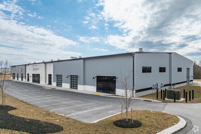
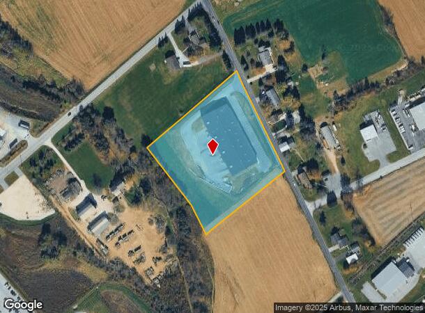
Property Record
670 Gitts Run Rd, Hanover, PA 17331

NEARBY LISTINGS FOR SALE OR LEASE
Property Detail
670 Gitts Run Rd
York-Hanover, PA
Gty Inc
44-000-ED-0038.D0-00000
LOT 4; GTY INC; PP RR-654 RR-1045
Warehouse
York
AE
Pennsylvania
42133C0404F
5.57 AC
2025
York County
2025
Philadelphia
022000
DEMOGRAPHICS near 670 Gitts Run Rd
1 Mile
3 Mile
5 Mile
2024 Total Population
804
31,492
64,135
2029 Population
843
32,231
65,858
Pop Growth 2024-2029
+ 4.85%
+ 2.35%
+ 2.69%
Average Age
44
42
43
2024 Total Households
326
13,281
25,645
HH Growth 2024-2029
+ 5.21%
+ 2.33%
+ 2.67%
Median Household Inc
$81,250
$63,283
$69,013
Avg Household Size
2.40
2.30
2.40
2024 Avg HH Vehicles
2.00
2.00
2.00
Median Home Value
$219,298
$186,191
$202,790
Median Year Built
1989
1965
1977
Nearby Places
Map Layers
Map Styles
 Street
 Aerial
- Restaurants
- Banks
- Shops
- Fitness
- Groceries
PUBLIC TRANSPORTATION
AIRPORT
Harrisburg International
DRIVE
WALK
Distance
Harrisburg International
69 min
46.3 mi
Freight Ports
Port of Baltimore
DRIVE
WALK
Distance
Port of Baltimore
80 min
54.2 mi
SALE & LEASE HISTORY
LISTING DATE
SALE/LEASE

Jul 08, 2024
For Sale
Jul 08, 2024
For Lease
Nearby Properties
Address
Land Use
TOTAL SIZE
Lot Size
Zoning
Address
Land Use
TOTAL SIZE
Lot Size
Zoning
35.99 AC
Address
Land Use
TOTAL SIZE
Lot Size
Zoning
23,050 SF
26.70 AC
CM
Address
Land Use
TOTAL SIZE
Lot Size
Zoning
129,869 SF
44.23 AC
ID
Address
Land Use
TOTAL SIZE
Lot Size
Zoning
190,175 SF
20.98 AC
ID
Address
Land Use
TOTAL SIZE
Lot Size
Zoning
24.39 AC
CI
Address
Land Use
TOTAL SIZE
Lot Size
Zoning
195,797 SF
20.31 AC
CM
Address
Land Use
TOTAL SIZE
Lot Size
Zoning
360,608 SF
46.91 AC
ID
Address
Land Use
TOTAL SIZE
Lot Size
Zoning
49,736 SF
20.73 AC
CM
Address
Land Use
TOTAL SIZE
Lot Size
Zoning
137,390 SF
17.47 AC
M
Address
Land Use
TOTAL SIZE
Lot Size
Zoning
16,669 SF
1.51 AC
Address
Land Use
TOTAL SIZE
Lot Size
Zoning
386,528 SF
2.35 AC
ID
Address
Land Use
TOTAL SIZE
Lot Size
Zoning
143,998 SF
21.94 AC
I
Address
Land Use
TOTAL SIZE
Lot Size
Zoning
207,780 SF
16.72 AC
CM
Address
Land Use
TOTAL SIZE
Lot Size
Zoning
13.23 AC
CI
Address
Land Use
TOTAL SIZE
Lot Size
Zoning
149,760 SF
22.93 AC
I
Address
Land Use
TOTAL SIZE
Lot Size
Zoning
60,590 SF
11.04 AC
IND
Address
Land Use
TOTAL SIZE
Lot Size
Zoning
67,650 SF
7.42 AC
RS
Address
Land Use
TOTAL SIZE
Lot Size
Zoning
376,800 SF
26.23 AC
ID
Address
Land Use
TOTAL SIZE
Lot Size
Zoning
271,646 SF
22.51 AC
IND
Address
Land Use
TOTAL SIZE
Lot Size
Zoning
Address
Land Use
TOTAL SIZE
Lot Size
Zoning
291,626 SF
39.16 AC
ID
Address
Land Use
TOTAL SIZE
Lot Size
Zoning
307,500 SF
23.24 AC
ID
Address
Land Use
TOTAL SIZE
Lot Size
Zoning
88,422 SF
12.66 AC
I
Address
Land Use
TOTAL SIZE
Lot Size
Zoning
9.80 AC
CI
Address
Land Use
TOTAL SIZE
Lot Size
Zoning
196,848 SF
7.78 AC
RS
Address
Land Use
TOTAL SIZE
Lot Size
Zoning
9.64 AC
CI
Address
Land Use
TOTAL SIZE
Lot Size
Zoning
109,544 SF
15.81 AC
CM
Address
Land Use
TOTAL SIZE
Lot Size
Zoning
Address
Land Use
TOTAL SIZE
Lot Size
Zoning
11.42 AC
C
Address
Land Use
TOTAL SIZE
Lot Size
Zoning
12,000 SF
8.30 AC
M
The World's #1 Commercial Real Estate Marketplace
Connect with us
© 2025 CoStar Group
The information above has been obtained from sources believed reliable. While we do not doubt its accuracy we have not verified it and make no guarantee, warranty or representation about it. It is your responsibility to independently confirm its accuracy and completeness. Any projections, opinions, assumptions, or estimates used are for example only and do not represent the current or future performance of the property. The value of this transaction to you depends on tax and other factors which should be evaluated by your tax, financial, and legal advisors. You and your advisors should conduct a careful, independent investigation of the property to determine to your satisfaction the suitability of the property for your needs.