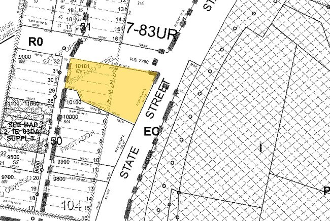
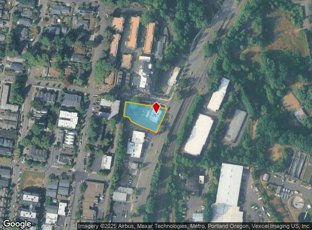
Property Record
670 N State St, Lake Oswego, OR 97034
NEARBY LISTINGS FOR SALE OR LEASE
Property Detail
670 N State St
Portland-Vancouver-Hillsboro, OR-WA
Ext Ore Iron&Steel
00194523
94 EXT ORE IRON&STEEL LTS1THRU3 PT LTS4&5 BK50 PT SEC 3 T2SR1E
Commercialbuilding
Clackamas
X
Oregon
41067C0575E
1-3
2025
0.53 AC
2025
Lake Oswego/West Linn
020102
Portland
1 SF
DEMOGRAPHICS near 670 N State St
1 Mile
3 Mile
5 Mile
2024 Total Population
11,236
91,700
278,748
2029 Population
11,651
93,635
281,187
Pop Growth 2024-2029
+ 3.69%
+ 2.11%
+ 0.87%
Average Age
48
44
42
2024 Total Households
5,076
38,118
114,319
HH Growth 2024-2029
+ 3.80%
+ 2.12%
+ 0.78%
Median Household Inc
$104,244
$99,303
$96,066
Avg Household Size
2.20
2.30
2.40
2024 Avg HH Vehicles
2.00
2.00
2.00
Median Home Value
$862,823
$667,150
$607,145
Median Year Built
1974
1975
1976
Nearby Places
Map Layers
Map Styles
 Street
 Aerial
- Restaurants
- Banks
- Shops
- Fitness
- Groceries
PUBLIC TRANSPORTATION
COMMUTER RAIL
Tigard Transit Center (Westside Express Service - Tri-County Metropolitan Transportation District of Oregon Rail (TriMet Rail))
DRIVE
WALK
Distance
Tigard Transit Center (Westside Express Service - Tri-County Metropolitan Transportation District of Oregon Rail (TriMet Rail))
15 min
6.8 mi
Oregon City Amtrak (Amtrak Cascades - Amtrak)
DRIVE
WALK
Distance
Oregon City Amtrak (Amtrak Cascades - Amtrak)
16 min
6.8 mi
AIRPORT
Portland International
DRIVE
WALK
Distance
Portland International
33 min
19.6 mi
Freight Ports
Port of Portland
DRIVE
WALK
Distance
Port of Portland
20 min
10.8 mi
Nearby Properties
Address
Land Use
TOTAL SIZE
Lot Size
Zoning
Address
Land Use
TOTAL SIZE
Lot Size
Zoning
931,749 SF
85.50 AC
CI1
Address
Land Use
TOTAL SIZE
Lot Size
Zoning
Address
Land Use
TOTAL SIZE
Lot Size
Zoning
138,295 SF
29.79 AC
CI1
Address
Land Use
TOTAL SIZE
Lot Size
Zoning
28.30 AC
EC/R-0
Address
Land Use
TOTAL SIZE
Lot Size
Zoning
6.48 AC
R-3
Address
Land Use
TOTAL SIZE
Lot Size
Zoning
Address
Land Use
TOTAL SIZE
Lot Size
Zoning
1 SF
1 AC
PF
Address
Land Use
TOTAL SIZE
Lot Size
Zoning
3,550 SF
3.99 AC
DMU
Address
Land Use
TOTAL SIZE
Lot Size
Zoning
5,724 SF
13.95 AC
NC/R-0
Address
Land Use
TOTAL SIZE
Lot Size
Zoning
1 SF
0.14 AC
EC
Address
Land Use
TOTAL SIZE
Lot Size
Zoning
10.35 AC
PF
Address
Land Use
TOTAL SIZE
Lot Size
Zoning
0.26 AC
C3
Address
Land Use
TOTAL SIZE
Lot Size
Zoning
21.39 AC
CI
Address
Land Use
TOTAL SIZE
Lot Size
Zoning
11.35 AC
C3
Address
Land Use
TOTAL SIZE
Lot Size
Zoning
62,048 SF
8.58 AC
R20
Address
Land Use
TOTAL SIZE
Lot Size
Zoning
35.26 AC
PNA
Address
Land Use
TOTAL SIZE
Lot Size
Zoning
11.10 AC
HDR
Address
Land Use
TOTAL SIZE
Lot Size
Zoning
1.61 AC
DMU
Address
Land Use
TOTAL SIZE
Lot Size
Zoning
1 SF
4.73 AC
R-3
Address
Land Use
TOTAL SIZE
Lot Size
Zoning
7 AC
NME
Address
Land Use
TOTAL SIZE
Lot Size
Zoning
22.01 AC
BI
Address
Land Use
TOTAL SIZE
Lot Size
Zoning
6 AC
R-0
Address
Land Use
TOTAL SIZE
Lot Size
Zoning
122,430 SF
10.85 AC
NC
Address
Land Use
TOTAL SIZE
Lot Size
Zoning
3.45 AC
R-15
Address
Land Use
TOTAL SIZE
Lot Size
Zoning
1 SF
11.53 AC
OC/R-3
Address
Land Use
TOTAL SIZE
Lot Size
Zoning
Address
Land Use
TOTAL SIZE
Lot Size
Zoning
121,443 SF
6.58 AC
NC/R-0
Address
Land Use
TOTAL SIZE
Lot Size
Zoning
6 AC
HDR
Address
Land Use
TOTAL SIZE
Lot Size
Zoning
9.67 AC
C3
Address
Land Use
TOTAL SIZE
Lot Size
Zoning
1.43 AC
C3
The World's #1 Commercial Real Estate Marketplace
Connect with us
© 2026 CoStar Group
The information above has been obtained from sources believed reliable. While we do not doubt its accuracy we have not verified it and make no guarantee, warranty or representation about it. It is your responsibility to independently confirm its accuracy and completeness. Any projections, opinions, assumptions, or estimates used are for example only and do not represent the current or future performance of the property. The value of this transaction to you depends on tax and other factors which should be evaluated by your tax, financial, and legal advisors. You and your advisors should conduct a careful, independent investigation of the property to determine to your satisfaction the suitability of the property for your needs.