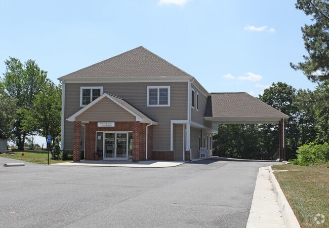
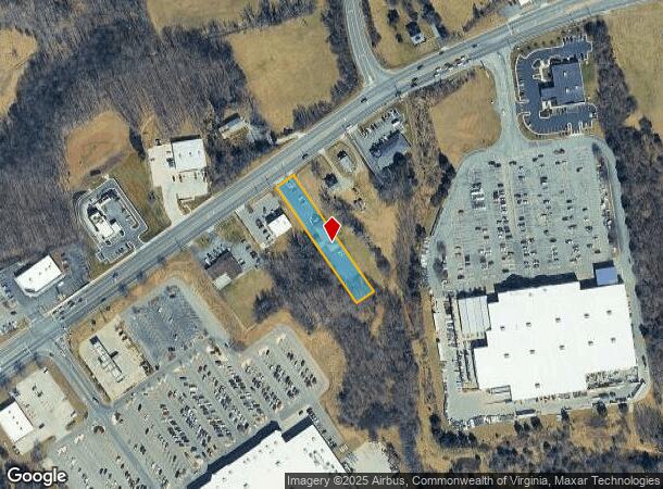
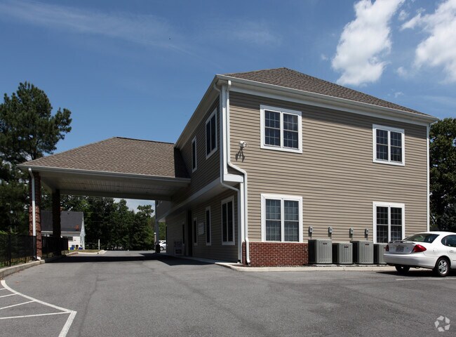
Property Record
670 Old Franklin Tpke, Rocky Mount, VA 24151
NEARBY LISTINGS FOR SALE OR LEASE
Property Detail
670 Old Franklin Tpke
Roanoke, VA
Survey Prepared For David E Nichols
2020001600
RT 40 E LOT 13 14 & PT 15
Officebuilding
Franklin
X
Virginia
51067C0215C
13
2025
0.58 AC
2025
South Franklin County
020200
Roanoke
5,367 SF
DEMOGRAPHICS near 670 Old Franklin Tpke
1 Mile
3 Mile
5 Mile
2024 Total Population
684
6,981
14,042
2029 Population
685
7,027
14,121
Pop Growth 2024-2029
+ 0.15%
+ 0.66%
+ 0.56%
Average Age
43
42
42
2024 Total Households
306
3,022
5,912
HH Growth 2024-2029
0.00%
+ 0.46%
+ 0.34%
Median Household Inc
$69,435
$51,377
$56,490
Avg Household Size
2.20
2.20
2.30
2024 Avg HH Vehicles
3.00
2.00
2.00
Median Home Value
$181,159
$168,934
$181,171
Median Year Built
1984
1977
1978
Nearby Places
Map Layers
Map Styles
 Street
 Aerial
- Restaurants
- Banks
- Shops
- Fitness
- Groceries
PUBLIC TRANSPORTATION
AIRPORT
Roanoke/Blacksburg Regional (Woodrum Field)
DRIVE
WALK
Distance
Roanoke/Blacksburg Regional (Woodrum Field)
42 min
29.7 mi
Freight Ports
Virginia Port Authority - Richmond
DRIVE
WALK
Distance
Virginia Port Authority - Richmond
229 min
168.0 mi
Nearby Properties
Address
Land Use
TOTAL SIZE
Lot Size
Zoning
Address
Land Use
TOTAL SIZE
Lot Size
Zoning
131,046 SF
32.45 AC
POS
Address
Land Use
TOTAL SIZE
Lot Size
Zoning
96,370 SF
32.42 AC
POS
Address
Land Use
TOTAL SIZE
Lot Size
Zoning
63,050 SF
15 AC
C1
Address
Land Use
TOTAL SIZE
Lot Size
Zoning
44,126 SF
3.10 AC
CBD
Address
Land Use
TOTAL SIZE
Lot Size
Zoning
52,544 SF
13.35 AC
GB
Address
Land Use
TOTAL SIZE
Lot Size
Zoning
147,812 SF
35.07 AC
GB
Address
Land Use
TOTAL SIZE
Lot Size
Zoning
49,056 SF
17.03 AC
GB
Address
Land Use
TOTAL SIZE
Lot Size
Zoning
54,377 SF
8.44 AC
C1
Address
Land Use
TOTAL SIZE
Lot Size
Zoning
135,884 SF
35.66 AC
GB
Address
Land Use
TOTAL SIZE
Lot Size
Zoning
51,657 SF
6.15 AC
R2
Address
Land Use
TOTAL SIZE
Lot Size
Zoning
70,122 SF
15.97 AC
GB
Address
Land Use
TOTAL SIZE
Lot Size
Zoning
49,482 SF
CBD
Address
Land Use
TOTAL SIZE
Lot Size
Zoning
60,434 SF
12.67 AC
R1
Address
Land Use
TOTAL SIZE
Lot Size
Zoning
39,180 SF
4.32 AC
CBD
Address
Land Use
TOTAL SIZE
Lot Size
Zoning
70,035 SF
16.70 AC
POS
Address
Land Use
TOTAL SIZE
Lot Size
Zoning
37.84 AC
M1
Address
Land Use
TOTAL SIZE
Lot Size
Zoning
45.10 AC
A1
Address
Land Use
TOTAL SIZE
Lot Size
Zoning
265,449 SF
12.25 AC
M2
Address
Land Use
TOTAL SIZE
Lot Size
Zoning
100,000 SF
10.51 AC
M1
Address
Land Use
TOTAL SIZE
Lot Size
Zoning
44,067 SF
15 AC
POS
Address
Land Use
TOTAL SIZE
Lot Size
Zoning
189,640 SF
17.98 AC
M1
Address
Land Use
TOTAL SIZE
Lot Size
Zoning
71,830 SF
17.41 AC
M2
Address
Land Use
TOTAL SIZE
Lot Size
Zoning
41,780 SF
4.50 AC
GB
Address
Land Use
TOTAL SIZE
Lot Size
Zoning
94,374 SF
25.06 AC
M1
Address
Land Use
TOTAL SIZE
Lot Size
Zoning
30,954 SF
2.46 AC
C1
Address
Land Use
TOTAL SIZE
Lot Size
Zoning
20,720 SF
1.18 AC
CBD
Address
Land Use
TOTAL SIZE
Lot Size
Zoning
20.30 AC
M1
Address
Land Use
TOTAL SIZE
Lot Size
Zoning
25,036 SF
1.70 AC
GB
Address
Land Use
TOTAL SIZE
Lot Size
Zoning
25,720 SF
41.19 AC
M2
Address
Land Use
TOTAL SIZE
Lot Size
Zoning
14,616 SF
1.38 AC
The World's #1 Commercial Real Estate Marketplace
Connect with us
© 2026 CoStar Group
The information above has been obtained from sources believed reliable. While we do not doubt its accuracy we have not verified it and make no guarantee, warranty or representation about it. It is your responsibility to independently confirm its accuracy and completeness. Any projections, opinions, assumptions, or estimates used are for example only and do not represent the current or future performance of the property. The value of this transaction to you depends on tax and other factors which should be evaluated by your tax, financial, and legal advisors. You and your advisors should conduct a careful, independent investigation of the property to determine to your satisfaction the suitability of the property for your needs.