Property Record
670 Opper St, Escondido, CA 92029
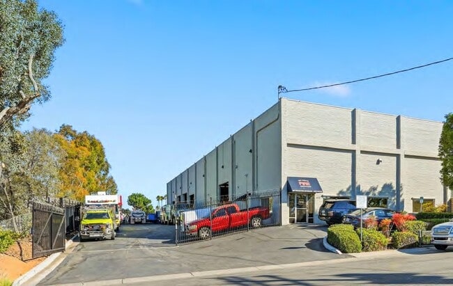

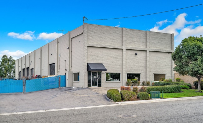
This Property Is For Sale
Property Detail
670 Opper St
228-420-31
PAR A TR PM00254
Lightindustrial
San Diego
M-1/M-2
California
B and X Area of moderate flood hazard, usually the area between the limits of the 100-year and 500-year floods.
0.50 AC
2024
Escondido
2025
San Diego
020311
San Diego-Chula Vista-Carlsbad, CA
9,750 SF
NEARBY LISTINGS FOR SALE OR LEASE
DEMOGRAPHICS near 670 Opper St
1 mile
3 mile
5 mile
2025 Total Population
8,466
117,254
240,126
2030 Population
8,573
117,533
240,134
Pop Growth 2025-2030
+ 1.26%
+ 0.24%
0.00%
Average Age
44
38
38
2025 Total Households
3,185
38,499
76,794
HH Growth 2025-2030
+ 1.48%
+ 0.11%
(0.10%)
Median Household Inc
$98,678
$92,074
$97,157
Avg Household Size
2.60
2.90
3.00
2025 Avg HH Vehicles
2.00
2.00
2.00
Median Home Value
$725,295
$741,346
$786,129
Median Year Built
1980
1984
1982
Nearby Places
Map Layers
Map Styles
 Street
 Aerial
Layers
 Traffic
 Biking
Places
Listings with unknown addresses are not visible on the map
- Restaurants
- Banks
- Shops
- Fitness
- Groceries
PUBLIC TRANSPORTATION
TRANSIT/SUBWAY
Nordahl Road (Sprinter - San Diego North County Transit District (Coaster/Sprinter/Breeze))
Drive
Walk
Distance
Nordahl Road (Sprinter - San Diego North County Transit District (Coaster/Sprinter/Breeze))
1 min
5 min
0.3 mi
AIRPORT
San Diego International
Drive
Walk
Distance
San Diego International
42 min
32.2 mi
Freight Ports
Port of San Diego
Drive
Walk
Distance
Port of San Diego
45 min
34.4 mi
Nearby Properties
Address
Land Use
TOTAL SIZE
Lot Size
Zoning
Address
Land Use
TOTAL SIZE
Lot Size
Zoning
27.98 AC
SPA
Address
Land Use
TOTAL SIZE
Lot Size
Zoning
14.98 AC
R-1-10
Address
Land Use
TOTAL SIZE
Lot Size
Zoning
9.77 AC
PD-R-18
Address
Land Use
TOTAL SIZE
Lot Size
Zoning
9,999 SF
15.37 AC
SPA
Address
Land Use
TOTAL SIZE
Lot Size
Zoning
10.82 AC
SPA
Address
Land Use
TOTAL SIZE
Lot Size
Zoning
Address
Land Use
TOTAL SIZE
Lot Size
Zoning
71,656 SF
S-P
Address
Land Use
TOTAL SIZE
Lot Size
Zoning
Address
Land Use
TOTAL SIZE
Lot Size
Zoning
9.88 AC
R-3-10
Address
Land Use
TOTAL SIZE
Lot Size
Zoning
SPECIFIC P
Address
Land Use
TOTAL SIZE
Lot Size
Zoning
75,138 SF
C
Address
Land Use
TOTAL SIZE
Lot Size
Zoning
80,064 SF
1.53 AC
S-P
Address
Land Use
TOTAL SIZE
Lot Size
Zoning
7.90 AC
PD-C
Address
Land Use
TOTAL SIZE
Lot Size
Zoning
7.60 AC
R-3-18
Address
Land Use
TOTAL SIZE
Lot Size
Zoning
Address
Land Use
TOTAL SIZE
Lot Size
Zoning
5.94 AC
PD-R-24
Address
Land Use
TOTAL SIZE
Lot Size
Zoning
99,461 SF
4.89 AC
SPA
Address
Land Use
TOTAL SIZE
Lot Size
Zoning
10.80 AC
SPA
Address
Land Use
TOTAL SIZE
Lot Size
Zoning
1.94 AC
C
Address
Land Use
TOTAL SIZE
Lot Size
Zoning
8.30 AC
R-2-12
Address
Land Use
TOTAL SIZE
Lot Size
Zoning
Address
Land Use
TOTAL SIZE
Lot Size
Zoning
97,874 SF
8.47 AC
R-2-12
Address
Land Use
TOTAL SIZE
Lot Size
Zoning
1.49 AC
SPA
Address
Land Use
TOTAL SIZE
Lot Size
Zoning
2.98 AC
S-P
Address
Land Use
TOTAL SIZE
Lot Size
Zoning
13.99 AC
PD-C
Address
Land Use
TOTAL SIZE
Lot Size
Zoning
7.06 AC
SR
Address
Land Use
TOTAL SIZE
Lot Size
Zoning
6.24 AC
R-3-18
Address
Land Use
TOTAL SIZE
Lot Size
Zoning
95,713 SF
0.51 AC
C
Address
Land Use
TOTAL SIZE
Lot Size
Zoning
97,090 SF
5.38 AC
R-3-18
Address
Land Use
TOTAL SIZE
Lot Size
Zoning
3.06 AC
S-P
The World's #1 Commercial Real Estate Marketplace
Connect with us
© 2026 CoStar Group
The information above has been obtained from sources believed reliable. While we do not doubt its accuracy we have not verified it and make no guarantee, warranty or representation about it. It is your responsibility to independently confirm its accuracy and completeness. Any projections, opinions, assumptions, or estimates used are for example only and do not represent the current or future performance of the property. The value of this transaction to you depends on tax and other factors which should be evaluated by your tax, financial, and legal advisors. You and your advisors should conduct a careful, independent investigation of the property to determine to your satisfaction the suitability of the property for your needs.