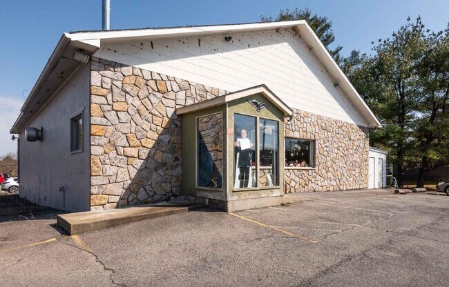
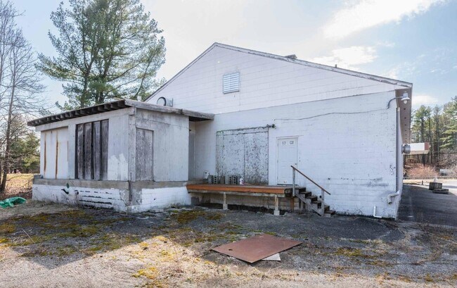
Property Record
670 Route 145, Cairo, NY 12413

NEARBY LISTINGS FOR SALE OR LEASE
Property Detail
670 Route 145
Gymhealthspa
Greene
X
New York
36039C0233F
5.200
2025
0.61 AC
2024
Greene County
080501
Albany/Schenectady/Troy
3,995 SF
192400-083-000-0002-005-200-0000
DEMOGRAPHICS near 670 Route 145
1 Mile
3 Mile
5 Mile
2024 Total Population
519
4,012
8,022
2029 Population
533
4,068
8,142
Pop Growth 2024-2029
+ 2.70%
+ 1.40%
+ 1.50%
Average Age
43
44
44
2024 Total Households
227
1,712
3,396
HH Growth 2024-2029
+ 2.64%
+ 1.23%
+ 1.30%
Median Household Inc
$71,086
$76,627
$73,012
Avg Household Size
2.20
2.30
2.30
2024 Avg HH Vehicles
2.00
2.00
2.00
Median Home Value
$175,293
$187,273
$188,399
Median Year Built
1981
1977
1978
Nearby Places
Map Layers
Map Styles
 Street
 Aerial
- Restaurants
- Banks
- Shops
- Fitness
- Groceries
SALE & LEASE HISTORY
LISTING DATE
SALE/LEASE

May 10, 2024
For Sale
Jun 28, 2017
For Sale
Jun 04, 2018
For Sale
Jan 09, 2018
For Sale
Nearby Properties
Address
Land Use
TOTAL SIZE
Lot Size
Zoning
Address
Land Use
TOTAL SIZE
Lot Size
Zoning
110,538 SF
45 AC
01 - NOT Z
Address
Land Use
TOTAL SIZE
Lot Size
Zoning
72,654 SF
24.10 AC
01 - NOT Z
Address
Land Use
TOTAL SIZE
Lot Size
Zoning
1,800 SF
17.75 AC
01
Address
Land Use
TOTAL SIZE
Lot Size
Zoning
24,884 SF
131.20 AC
01 - NOT Z
Address
Land Use
TOTAL SIZE
Lot Size
Zoning
Address
Land Use
TOTAL SIZE
Lot Size
Zoning
7,299 SF
1.82 AC
01 - NOT Z
Address
Land Use
TOTAL SIZE
Lot Size
Zoning
8,768 SF
30.80 AC
01 - NOT Z
Address
Land Use
TOTAL SIZE
Lot Size
Zoning
27,074 SF
15.84 AC
01 - NOT Z
Address
Land Use
TOTAL SIZE
Lot Size
Zoning
1,652 SF
7.61 AC
01 - NOT Z
Address
Land Use
TOTAL SIZE
Lot Size
Zoning
1,144 SF
177.30 AC
02 - SINGL
Address
Land Use
TOTAL SIZE
Lot Size
Zoning
1,160 SF
92.53 AC
01 - NOT Z
Address
Land Use
TOTAL SIZE
Lot Size
Zoning
18,436 SF
16.50 AC
01 - NOT Z
Address
Land Use
TOTAL SIZE
Lot Size
Zoning
7,200 SF
2.10 AC
01 - NOT Z
Address
Land Use
TOTAL SIZE
Lot Size
Zoning
16,833 SF
100.04 AC
01 - NOT Z
Address
Land Use
TOTAL SIZE
Lot Size
Zoning
18,420 SF
3.29 AC
01 - NOT Z
Address
Land Use
TOTAL SIZE
Lot Size
Zoning
2,394 SF
7.87 AC
01 - NOT Z
Address
Land Use
TOTAL SIZE
Lot Size
Zoning
15,624 SF
1.38 AC
03 - MULTI
Address
Land Use
TOTAL SIZE
Lot Size
Zoning
7,050 SF
2.16 AC
01 - NOT Z
Address
Land Use
TOTAL SIZE
Lot Size
Zoning
3,968 SF
1.05 AC
01 - NOT Z
Address
Land Use
TOTAL SIZE
Lot Size
Zoning
2,316 SF
110.25 AC
01 - NOT Z
Address
Land Use
TOTAL SIZE
Lot Size
Zoning
20,392 SF
3.35 AC
01 - NOT Z
Address
Land Use
TOTAL SIZE
Lot Size
Zoning
4,096 SF
11 AC
01 - NOT Z
Address
Land Use
TOTAL SIZE
Lot Size
Zoning
8,112 SF
0.51 AC
01 - NOT Z
Address
Land Use
TOTAL SIZE
Lot Size
Zoning
6,840 SF
6 AC
01 - NOT Z
Address
Land Use
TOTAL SIZE
Lot Size
Zoning
5,884 SF
6.30 AC
01 - NOT Z
Address
Land Use
TOTAL SIZE
Lot Size
Zoning
8,206 SF
4.70 AC
01 - NOT Z
Address
Land Use
TOTAL SIZE
Lot Size
Zoning
3,644 SF
0.49 AC
01 - NOT Z
Address
Land Use
TOTAL SIZE
Lot Size
Zoning
76 AC
01
Address
Land Use
TOTAL SIZE
Lot Size
Zoning
1,344 SF
185.90 AC
01 - NOT Z
Address
Land Use
TOTAL SIZE
Lot Size
Zoning
1,200 SF
35.62 AC
01 - NOT Z
The World's #1 Commercial Real Estate Marketplace
Connect with us
© 2026 CoStar Group
The information above has been obtained from sources believed reliable. While we do not doubt its accuracy we have not verified it and make no guarantee, warranty or representation about it. It is your responsibility to independently confirm its accuracy and completeness. Any projections, opinions, assumptions, or estimates used are for example only and do not represent the current or future performance of the property. The value of this transaction to you depends on tax and other factors which should be evaluated by your tax, financial, and legal advisors. You and your advisors should conduct a careful, independent investigation of the property to determine to your satisfaction the suitability of the property for your needs.