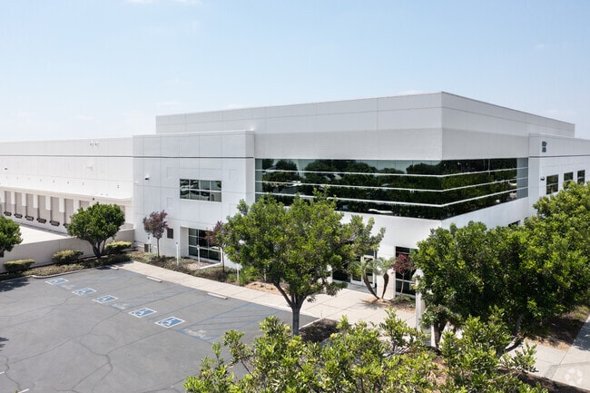
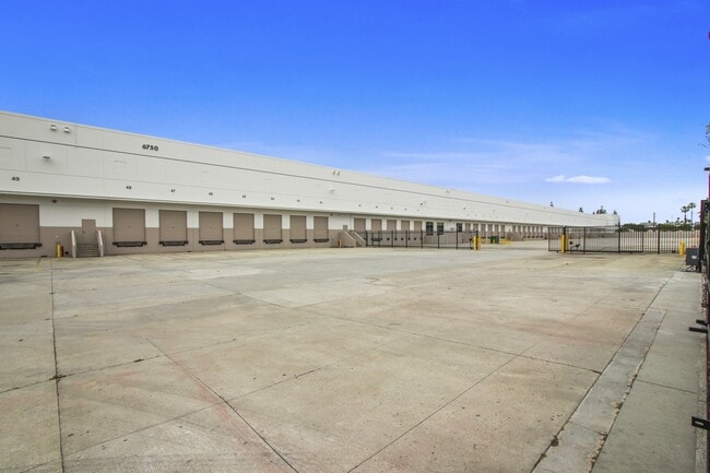
Property Record
6700 Artesia Blvd, Buena Park, CA 90620

Current Lease Availabilities
NEARBY LISTINGS FOR SALE OR LEASE
Property Detail
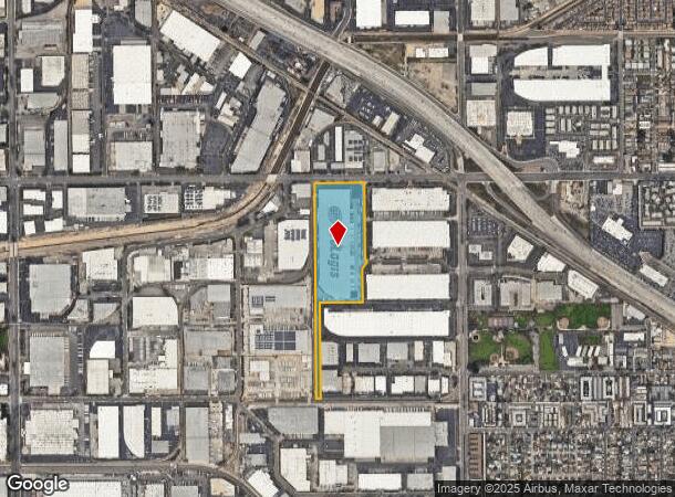
6700 Artesia Blvd
Anaheim-Santa Ana-Irvine, CA
Parcel Map 98-258
276-041-15
P BK 312 PG 5 PAR 1 PM 312-5 PAR 1 POR OF PAR
Industrialgeneral
Orange
X
California
06059C0107J
1
2024
19.26 AC
2025
Buena Park
110500
Orange County (California)
DEMOGRAPHICS near 6700 Artesia Blvd
1 Mile
3 Mile
5 Mile
2024 Total Population
11,884
183,396
615,457
2029 Population
11,761
179,408
601,382
Pop Growth 2024-2029
(1.04%)
(2.17%)
(2.29%)
Average Age
36
40
40
2024 Total Households
3,517
55,998
185,250
HH Growth 2024-2029
(1.08%)
(2.39%)
(2.47%)
Median Household Inc
$72,295
$94,259
$90,628
Avg Household Size
3.30
3.20
3.20
2024 Avg HH Vehicles
2.00
2.00
2.00
Median Home Value
$733,857
$746,838
$727,077
Median Year Built
1975
1969
1966
Nearby Places
Map Layers
Map Styles
 Street
 Aerial
- Restaurants
- Banks
- Shops
- Fitness
- Groceries
PUBLIC TRANSPORTATION
COMMUTER RAIL
Buena Park (91 Line - Southern California Regional Rail Authority (Metrolink), Orange County Line - Southern California Regional Rail Authority (Metrolink))
DRIVE
WALK
Distance
Buena Park (91 Line - Southern California Regional Rail Authority (Metrolink), Orange County Line - Southern California Regional Rail Authority (Metrolink))
5 min
2.2 mi
Norwalk/Santa Fe Springs (91 Line - Southern California Regional Rail Authority (Metrolink), Orange County Line - Southern California Regional Rail Authority (Metrolink))
DRIVE
WALK
Distance
Norwalk/Santa Fe Springs (91 Line - Southern California Regional Rail Authority (Metrolink), Orange County Line - Southern California Regional Rail Authority (Metrolink))
10 min
6.0 mi
AIRPORT
Long Beach (Daugherty Field)
DRIVE
WALK
Distance
Long Beach (Daugherty Field)
22 min
13.7 mi
John Wayne/Orange County
DRIVE
WALK
Distance
John Wayne/Orange County
25 min
19.9 mi
Los Angeles International
DRIVE
WALK
Distance
Los Angeles International
36 min
26.7 mi
Freight Ports
Port of Long Beach
DRIVE
WALK
Distance
Port of Long Beach
29 min
19.3 mi
Nearby Properties
Address
Land Use
TOTAL SIZE
Lot Size
Zoning
Address
Land Use
TOTAL SIZE
Lot Size
Zoning
57.25 AC
Address
Land Use
TOTAL SIZE
Lot Size
Zoning
150,561 SF
65.24 AC
LMPUD
Address
Land Use
TOTAL SIZE
Lot Size
Zoning
476,442 SF
22.77 AC
Address
Land Use
TOTAL SIZE
Lot Size
Zoning
437,823 SF
19.27 AC
LMM2*
Address
Land Use
TOTAL SIZE
Lot Size
Zoning
564,705 SF
14.35 AC
LCA25*
Address
Land Use
TOTAL SIZE
Lot Size
Zoning
Address
Land Use
TOTAL SIZE
Lot Size
Zoning
12.50 AC
Address
Land Use
TOTAL SIZE
Lot Size
Zoning
281,238 SF
14.83 AC
Address
Land Use
TOTAL SIZE
Lot Size
Zoning
225,016 SF
9.95 AC
LMM2*
Address
Land Use
TOTAL SIZE
Lot Size
Zoning
13.75 AC
Address
Land Use
TOTAL SIZE
Lot Size
Zoning
369,940 SF
8.70 AC
CEM
Address
Land Use
TOTAL SIZE
Lot Size
Zoning
5.90 AC
Address
Land Use
TOTAL SIZE
Lot Size
Zoning
26.92 AC
Address
Land Use
TOTAL SIZE
Lot Size
Zoning
224,131 SF
9.03 AC
CEM
Address
Land Use
TOTAL SIZE
Lot Size
Zoning
345,200 SF
8.51 AC
LMM2
Address
Land Use
TOTAL SIZE
Lot Size
Zoning
128,481 SF
19.42 AC
LMR1*
Address
Land Use
TOTAL SIZE
Lot Size
Zoning
277,756 SF
10.47 AC
LMM2*
Address
Land Use
TOTAL SIZE
Lot Size
Zoning
46.74 AC
Address
Land Use
TOTAL SIZE
Lot Size
Zoning
266,337 SF
2.40 AC
CE-ADP-16
Address
Land Use
TOTAL SIZE
Lot Size
Zoning
272,080 SF
13.34 AC
C
Address
Land Use
TOTAL SIZE
Lot Size
Zoning
163,350 SF
7.58 AC
CEM
Address
Land Use
TOTAL SIZE
Lot Size
Zoning
249,572 SF
11.76 AC
LMM2*
Address
Land Use
TOTAL SIZE
Lot Size
Zoning
154,616 SF
7.53 AC
CEM
Address
Land Use
TOTAL SIZE
Lot Size
Zoning
237,944 SF
12.09 AC
LMM2*
Address
Land Use
TOTAL SIZE
Lot Size
Zoning
444,784 SF
18.92 AC
SSM2*
Address
Land Use
TOTAL SIZE
Lot Size
Zoning
140,212 SF
6.65 AC
LMM2*
Address
Land Use
TOTAL SIZE
Lot Size
Zoning
21.64 AC
Address
Land Use
TOTAL SIZE
Lot Size
Zoning
1,102,724 SF
25.93 AC
LMM2*
Address
Land Use
TOTAL SIZE
Lot Size
Zoning
11.86 AC
The World's #1 Commercial Real Estate Marketplace
Connect with us
© 2026 CoStar Group
The information above has been obtained from sources believed reliable. While we do not doubt its accuracy we have not verified it and make no guarantee, warranty or representation about it. It is your responsibility to independently confirm its accuracy and completeness. Any projections, opinions, assumptions, or estimates used are for example only and do not represent the current or future performance of the property. The value of this transaction to you depends on tax and other factors which should be evaluated by your tax, financial, and legal advisors. You and your advisors should conduct a careful, independent investigation of the property to determine to your satisfaction the suitability of the property for your needs.