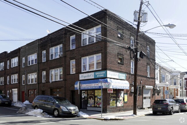
Property Record
6700 Palisade Ave, West New York, NJ 07093
NEARBY LISTINGS FOR SALE OR LEASE
Property Detail
6700 Palisade Ave
12-00007-0000-00001
Hudson
Commercialnec
New Jersey
X
1
34003C0267H
0.02 AC
2024
Hudson Waterfront
2025
Northern New Jersey
032400
New York-Jersey City-White Plains, NY-NJ
2,680 SF
DEMOGRAPHICS near 6700 Palisade Ave
1 Mile
3 Mile
5 Mile
2024 Total Population
96,564
631,751
1,939,978
2029 Population
92,074
593,579
1,822,306
Pop Growth 2024-2029
(4.65%)
(6.04%)
(6.07%)
Average Age
40
42
41
2024 Total Households
36,900
285,428
903,066
HH Growth 2024-2029
(5.05%)
(6.47%)
(6.37%)
Median Household Inc
$65,774
$93,302
$90,646
Avg Household Size
2.50
2.10
2.00
2024 Avg HH Vehicles
1.00
1.00
.00
Median Home Value
$432,433
$848,115
$827,814
Median Year Built
1963
1956
1958
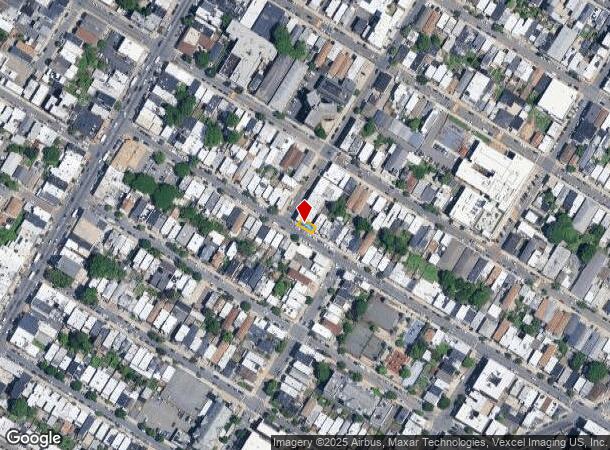
Nearby Places
Map Layers
Map Styles
 Street
 Aerial
- Restaurants
- Banks
- Shops
- Fitness
- Groceries
PUBLIC TRANSPORTATION
COMMUTER RAIL
New York Penn Station (Njt) (Babylon Branch - Long Island Rail Road, Far Rockaway Branch - Long Island Rail Road, Hempstead Branch - Long Island Rail Road, Long Beach Branch - Long Island Rail Road, Montauk Branch - Long Island Rail Road, Montclair-Boonton Line - Long Island Rail Road, Morris & Essex Gladstone Branch - Long Island Rail Road, Morris & Essex Morristown Line - Long Island Rail Road, North Jersey Coast Line - Long Island Rail Road, Northeast Corridor Line - Long Island Rail Road, Port Jefferson Branch - Long Island Rail Road, Port Washington Branch - Long Island Rail Road, Ronkonkoma Branch - Long Island Rail Road, West Hempstead Branch - Long Island Rail Road)
DRIVE
WALK
Distance
New York Penn Station (Njt) (Babylon Branch - Long Island Rail Road, Far Rockaway Branch - Long Island Rail Road, Hempstead Branch - Long Island Rail Road, Long Beach Branch - Long Island Rail Road, Montauk Branch - Long Island Rail Road, Montclair-Boonton Line - Long Island Rail Road, Morris & Essex Gladstone Branch - Long Island Rail Road, Morris & Essex Morristown Line - Long Island Rail Road, North Jersey Coast Line - Long Island Rail Road, Northeast Corridor Line - Long Island Rail Road, Port Jefferson Branch - Long Island Rail Road, Port Washington Branch - Long Island Rail Road, Ronkonkoma Branch - Long Island Rail Road, West Hempstead Branch - Long Island Rail Road)
14 min
5.4 mi
Ny Moynihan Train Hall At Penn Station (Crescent - Amtrak, Ethan Allen Express - Amtrak, Keystone Service - Amtrak, Lake Shore Limited - Amtrak, Northeast Regional - Amtrak)
DRIVE
WALK
Distance
Ny Moynihan Train Hall At Penn Station (Crescent - Amtrak, Ethan Allen Express - Amtrak, Keystone Service - Amtrak, Lake Shore Limited - Amtrak, Northeast Regional - Amtrak)
15 min
5.6 mi
AIRPORT
Newark Liberty International
DRIVE
WALK
Distance
Newark Liberty International
18 min
13.0 mi
LaGuardia
DRIVE
WALK
Distance
LaGuardia
31 min
14.1 mi
John F Kennedy International
DRIVE
WALK
Distance
John F Kennedy International
39 min
22.1 mi
Freight Ports
NY - Red Hook Container Terminal
DRIVE
WALK
Distance
NY - Red Hook Container Terminal
28 min
13.0 mi
Nearby Properties
Address
Land Use
TOTAL SIZE
Lot Size
Zoning
Address
Land Use
TOTAL SIZE
Lot Size
Zoning
4,060,596 SF
22.09 AC
M2-3
Address
Land Use
TOTAL SIZE
Lot Size
Zoning
2,245,112 SF
2.02 AC
C6-6
Address
Land Use
TOTAL SIZE
Lot Size
Zoning
1,783,434 SF
1.94 AC
C5-3
Address
Land Use
TOTAL SIZE
Lot Size
Zoning
2,521,850 SF
1.59 AC
C6-4
Address
Land Use
TOTAL SIZE
Lot Size
Zoning
1,445,092 SF
3.10 AC
C6-4
Address
Land Use
TOTAL SIZE
Lot Size
Zoning
2,221,336 SF
1.55 AC
C6-4
Address
Land Use
TOTAL SIZE
Lot Size
Zoning
2,636,182 SF
2.35 AC
C65.5
Address
Land Use
TOTAL SIZE
Lot Size
Zoning
2,734,038 SF
4.24 AC
C52.5
Address
Land Use
TOTAL SIZE
Lot Size
Zoning
1,897,491 SF
2.06 AC
C52.5
Address
Land Use
TOTAL SIZE
Lot Size
Zoning
1,233,684 SF
16.94 AC
PARK
Address
Land Use
TOTAL SIZE
Lot Size
Zoning
1,638,259 SF
1.43 AC
C52.5
Address
Land Use
TOTAL SIZE
Lot Size
Zoning
2,360,627 SF
2.08 AC
C6-7
Address
Land Use
TOTAL SIZE
Lot Size
Zoning
1,642,675 SF
1.05 AC
C6-7
Address
Land Use
TOTAL SIZE
Lot Size
Zoning
1,984,228 SF
1.95 AC
C65.5
Address
Land Use
TOTAL SIZE
Lot Size
Zoning
1,962,900 SF
1.89 AC
C66.5
Address
Land Use
TOTAL SIZE
Lot Size
Zoning
1,946,157 SF
1.49 AC
C6-4
Address
Land Use
TOTAL SIZE
Lot Size
Zoning
1,842,991 SF
2.08 AC
C66.5
Address
Land Use
TOTAL SIZE
Lot Size
Zoning
1,178,640 SF
0.92 AC
C6-4
Address
Land Use
TOTAL SIZE
Lot Size
Zoning
1,751,641 SF
1.84 AC
C6-4
Address
Land Use
TOTAL SIZE
Lot Size
Zoning
1,613,847 SF
1.84 AC
C66.5
Address
Land Use
TOTAL SIZE
Lot Size
Zoning
2,215,000 SF
6.43 AC
R9
Address
Land Use
TOTAL SIZE
Lot Size
Zoning
1,596,521 SF
1.34 AC
C6-4
Address
Land Use
TOTAL SIZE
Lot Size
Zoning
Address
Land Use
TOTAL SIZE
Lot Size
Zoning
1,805,894 SF
1.42 AC
C6-4
Address
Land Use
TOTAL SIZE
Lot Size
Zoning
264,420 SF
7.26 AC
C4-7
Address
Land Use
TOTAL SIZE
Lot Size
Zoning
431,963 SF
C67T
Address
Land Use
TOTAL SIZE
Lot Size
Zoning
1,649,604 SF
1.51 AC
C67T
Address
Land Use
TOTAL SIZE
Lot Size
Zoning
1,606,528 SF
1.84 AC
C6-6
Address
Land Use
TOTAL SIZE
Lot Size
Zoning
1,169,666 SF
1.42 AC
C52.5
Address
Land Use
TOTAL SIZE
Lot Size
Zoning
1,482,208 SF
1.71 AC
C5-3
The World's #1 Commercial Real Estate Marketplace
Connect with us
© 2025 CoStar Group
The information above has been obtained from sources believed reliable. While we do not doubt its accuracy we have not verified it and make no guarantee, warranty or representation about it. It is your responsibility to independently confirm its accuracy and completeness. Any projections, opinions, assumptions, or estimates used are for example only and do not represent the current or future performance of the property. The value of this transaction to you depends on tax and other factors which should be evaluated by your tax, financial, and legal advisors. You and your advisors should conduct a careful, independent investigation of the property to determine to your satisfaction the suitability of the property for your needs.